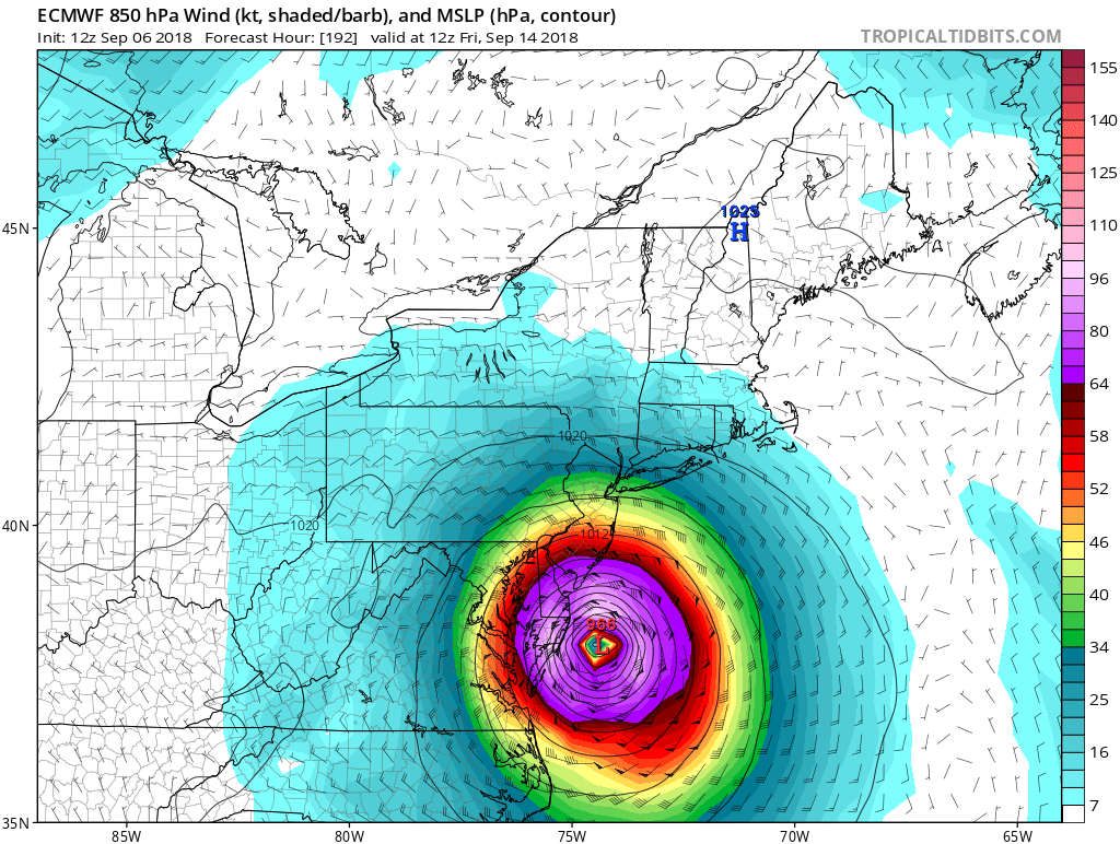
The European ECMWF forecast model is suggesting a landfall by Hurricane Florence next week somewhere in the Mid Atlantic. Known in the meteorology community as a reliable global forecast model, the latest ECMWF continues to show Florence being guided toward the U.S. East Coast by a powerful ridge of high pressure in the North Atlantic. While many storms often curve away from the coast, forecast guidance is suggesting the strong ridge would prevent such a curvature and drive Florence west somewhere towards the U.S. East Coast for an eventual landfall around the 13th of September.

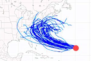
To understand the operational model output, one most also understand the ensemble approach to forecasting. Ensemble forecasting is a method used in numerical weather prediction. Instead of making a single forecast of the most likely weather, a set of forecasts is produced by computer software. This set of forecasts aims to give an indication of the range of possible future states of the atmosphere. The multiple simulations are conducted to account for the errors introduced by the use of imperfect initial conditions and errors introduced because of imperfections in the formulas the models use. Different models, such as the American GFS, uses a different approach to forecasting the environment and as such will produce different ensemble members than the European model. When the ensemble output of a variety of reliable forecasts runs is overlapped, the verified future atmospheric state should fall somewhere within the predicted ensemble spread. When there is significant spread among ensemble members of a specific forecast model, or even more spread when one ensemble is compared to another, uncertainty in the forecasts increase.
Weather forecasts are more probabilistic than deterministic. Because meteorology is still an imperfect science, the forecasts created, especially when it comes to the future track of tropical cyclones, is more about the most probable track moreso than a definite track. When looking at an ensemble model “spaghetti plot”, called such due to the numerous lines and squiggles that appear on a chart plotting them, know there’s a percentage chance of each track coming to fruition with some tracks having higher probability than others. While the operational model output appears to be deterministic, such as today’s 12z ECMWF run showing landfall in the DelMarVa, it is merely looking at these probabilities and plotting out a single track based on the more probable, but not definitive, track.

To add to the confusion, track error by meteorologists and by the computer forecast models they use, grow over time. While forecasts within 72 hours are good and within 48 hours in recent times have been stellar, the accuracy of tropical cyclone forecast tracks beyond 3 days diminish and beyond 5 days becomes unreliable. As such, while computer forecast models are aligning around the idea of an East Coast landfall, it is far too soon to say with certainty whether they are accurate. As nuances in the environment are better tracked by the forecast models, the extended forecast and the resulting extending range tropical cyclone tracks could shift significantly over time.
In the short-term and within the reliable forecast range of 72 hours, there is good agreement of where Hurricane Florence will go. However, over time, due to the spread of ensemble members, the lack of model-to-model continuity, and the overall lack of confidence in hurricane forecast tracks beyond 5 days, it is still too soon to say whether or not a U.S. landfall will occur. Based on the data available this afternoon, it appears there’s a 50/50 chance of landfall. Those odds will be refined in the coming days.
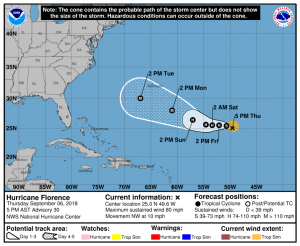
The National Hurricane Center’s official forecast map reflects a forecast cone of probability rather than a deterministic, specific expected track. The cone reflects where the center of the storm could be over time, with the highest probability in the center of it. The National Hurricane Center cautions: hurricanes are often large systems with impacts far from the center; while their forecast cone shows where the center can be, it does not illustrate the areas that could be lashed by fierce winds and heavy rains. The National Hurricane Center forecast also only goes out 5 days, showing there’s not much faith in tropical cyclone forecasts beyond that period due to all of the variability described here.
But with even a 50/50 chance of an East Coast landfall, it is imperative that people up and down the entire U.S. East Coast have a Hurricane Action Plan and monitor evolving forecasts in the coming days. If some of those ensemble members are right about an east coast landfall, it may become necessary to act on your Hurricane Action Plan in less than a week from now.