• Skip to primary navigation
  • Skip to main content
  • Skip to primary sidebar

Weatherboy

Weatherboy Weather News, Maps, RADAR, Satellite, and Forecasts.

  • Local
  • Earth Science News
  • RADAR
  • Current Warnings
  • Satellite
  • Current Maps
  • Forecast Maps
  • Video

Excessive Heat, Humidity Blast Country

by Weatherboy Team Meteorologist - June 28, 2018

Forecast temperatures for Saturday are in the 90's or higher for a large part of the country. When combined with humidity, it'll even feel more hot. Image: weatherboy.com
Forecast temperatures for Saturday are in the 90’s or higher for a large part of the country. When combined with humidity, it’ll even feel more hot. Image: weatherboy.com


People should know the difference between Heat Exhaustion and Heat Stroke. Image: National Weather Service
While the summer of 2018 is young, the heat and humidity typical of the middle of it will be here for the next several days. The start of the next heat wave in the Eastern U.S. will begin on Friday as hot and humid air starts to work its way north and east up the coast.

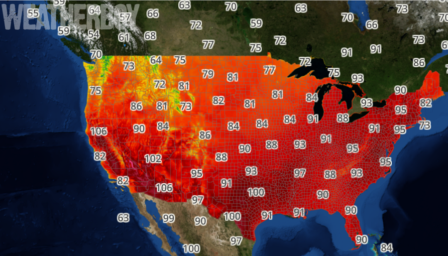
With the high heat comes high humidity.The key with respect to how hot it feels will be just how moist the air remains through the day. On Friday in the Mid Atlantic, winds are forecast to pick up a bit towards
the afternoon hours and remain more out of west direction, which would promote more atmospheric mixing. This mixing will allow the dew points to drop during times of peak heating; the dew points should fall enough to keep the heat index values below 100 for Friday. However, the mixing will fade away, setting the stage for a very hot and humid weekend.

An upper ridge will build across the Middle Atlantic states later Friday and Saturday and then remain across the region into early next week.  Dew points will begin to creep up later Saturday with excessive values expected on Sunday. This means that heat index values, which combine heat and humidity,  will be in the mid/upper 90s Saturday and in the upper 90s and low 100s for Sunday across the I-95 corridor from Washington, DC to Boston, MA, with some of the worst heat index values between Baltimore, MD and Philadelphia, PA.


While the heat is on, little in the way of rain is expected this weekend. A small chance of showers and storms will exist along the eastern U.S. on Monday with a greater chance of rain during the middle part of the new week. The next threat of rain will be dependent on how fast the ridge responsible for this hot blast lingers and how much upper level energy is able to move into the Mid Atlantic and Northeast.

Primary Sidebar

Sponsored Ad

Search

Latest News

  • Severe Weather Threat Returns to Mississippi Valley on Friday
  • Deadline for SBA Aid for Kauai Drought Coming Soon
  • Another Atmospheric River Event Slams into West Coast; More Epic Rain, Snow Expected
  • Anniversary of 1964 Great Alaskan “Good Friday” Earthquake and Tsunami
  • Tornado Watches, Warnings Issued as Severe Weather Impacts Louisiana, Mississippi, Alabama, & Gerogia
  • After Violent Night, Storms Shift to Ohio and Pennsylvania
  • Preliminary NTSB Report Shows Something other than Turbulence Killed Passenger on New England Flight
  • SEVERE Geomagnetic Storm Alert Issued; Massive Aurora On Display in North America
About | Careers | Contact | Contests
Terms | Privacy | Ad Choices
Weatherboy is a (R) Registered Trademark of isarithm LLC, All Rights Reserved.
All content herein is Copyright by Isarithm LLC 1997-2022