On this Fourth of July as America celebrates its independence for the 250th time, extreme heat, severe storms, and destructive winds are likely from Virginia to New Jersey including the nation’s capital in Washington DC where the most intense heat and storms are expected. The National Weather Service is warning people in this region to prepare for the worst while some Independence Day plans get canceled.
The combination of very hot and humid conditions with near to record breaking temperatures for multiple consecutive days increases the risk for heat related illnesses, especially for the elderly and the young, according to the National Weather Service. Because of that, they’ve issued an Extreme Heat Warning for the New York City metro area, all of New Jersey and Delaware, the entire Washington DC and Baltimore metro area, much of Maryland, Virginia, and eastern and southern Pennsylvania.
Scattered thunderstorms are forecast during the later afternoon and evening hours on this holiday. While storms will offer some relief from the heat, the extreme heat and humidity will help fuel severe thunderstorms with frequent cloud to ground lightning and destructive winds.
“If thunder roars, head indoors. If thunder is close enough to be heard, lightning is close enough to kill,” warns the National Weather Service.
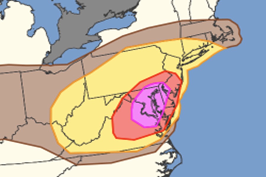
Clusters of storms will move across parts of the Allegheny Plateau into the Mid-Atlantic, with potential for widespread damaging wind gusts. According to the National Weather Service’s Storm Prediction Center (SPC), a belt of moderate mid-level westerly flow aloft currently extends across the Ohio Valley and Mid-Atlantic States, situated between the upper troughing over eastern Canada and higher heights over the southeast continental US. A modest vorticity maximum appears to be moving within these westerlies across Lower Michigan, downstream of two more prominent, convectively augmented vorticity maxima across Iowa and Kansas. There also appears to be a very modest shortwave trough moving over Kentucky, evidenced by a subtle shift in the mid-level winds across the region. The SPC says that both of these features are expected to continue eastward today, progressing into a very warm, moist, and unstable airmass across the Upper Ohio Valley and Mid-Atlantic by the early afternoon.
Interaction between the modest ascent associated with these features and the unstable airmass forecast to be in place will support thunderstorm development. This development is expected first over the Blue Ridge Mountains/Shenandoah Valley vicinity during the early afternoon before then progressing northeastward through northern Virginia, Washington DC, central Maryland, Delaware, and southern New Jersey.
Weak deep-layer shear amid a deeply mixed airmass with afternoon temperatures in the upper 90s to low 100s will support outflow-dominant storm structures, and strong cold pools capable of widespread damaging wind gusts. The SPC says an isolated gust or two around 70-75 mph is possible. A similar convective evolution is anticipated farther north from the Allegheny Plateau through the northern Mid-Atlantic and southern New England later in the afternoon as the Lower Michigan vorticity maximum moves through the region. Damaging gusts will be the primary risk here as well, with slightly less coverage and magnitude than farther south.
Thunderstorms will feature abundant lightning and heavy downpours which could lead to isolated flash flooding. Isolated tornadoes are possible too but the dominant threat will be from destructive straight-line winds.
With extreme heat and severe weather, many Fourth of July events have been canceled. The largest event cancellation is the National Independence Day Parade. In a statement on their website, they wrote, “The organizers of America ‘s National Independence Day Parade, scheduled for July 4, 2026, at 10:30 AM, have regretfully canceled the parade due to extreme heat in the Washington, DC, region. The National Weather Service has an Extreme Heat Warning for the District of Columbia, with heat index values expected to reach between 110°F and 115°F. This decision was made after extensive consultation with the National Park Service, the District of Columbia City Government, and Freedom 250, and careful consideration of the safety of our participants, spectators, and staff as the top priority.”
The Great American State Fair, a 16-day event on the National Mall, temporarily closed down earlier Friday amid reports that 44 attendees had to receive medical attention for heat-related illnesses. Authorities reported that 11 people were transported to an area hospital while 7 of those hospitalizations were considered “serious.” Today’s event opening was postponed due to the extreme heat and humidity.
With severe storms likely to build in the afternoon and evening, it is also likely many aerial fireworks and drone shows will be canceled due to the weather in the Mid Atlantic too.
