The National Weather Service office in Baltimore/Washington has confirmed that a tornado touched-down in Baltimore, Maryland on Monday. Several online weather personalities were critical of the National Weather Service to issue a warning for the storm responsible for the tornado, but it now appears the warning was needed.
A line of severe thunderstorms moved into the area during the afternoon of Monday, August 10th, 2026. The line interacted with the bay breeze, causing a brief waterspout on the Patapsco River and subsequent tornado at the Seagirt Marine Terminal in the Port of Baltimore and Dundalk.
The tornado was rated an EF-0. The Enhanced Fujita Scale or EF Scale, which became operational on February 1, 2007, is used to assign a tornado a ‘rating’ based on estimated wind speeds and related damage. When tornado-related damage is surveyed, it is compared to a list of Damage Indicators (DIs) and Degrees of Damage (DoD) which help estimate better the range of wind speeds the tornado likely produced. From that, a rating from EF0 to EF5 is assigned. In general, EF-0 tornadoes have 65-85 mph winds, EF-1 have 86-110 mph winds, EF-2 have 111-135 mph winds, EF-3 have 136-165 mph winds, EF-4 have 166-200 mph winds, and EF-5 tornadoes have winds in excess of 200 mph. The EF Scale was revised from the original Fujita Scale to reflect better examinations of tornado damage surveys so as to align wind speeds more closely with associated storm damage., with the new scale related to how most structures are designed.
On Tuesday, August 11, 2026, the National Weather Service Baltimore/Washington Weather Forecast Office sent a team to the City of Baltimore and Baltimore County to survey storm damage from thunderstorms that occurred on August 10, 2026. Additionally, several videos from trusted sources were received and analyzed, along with weather radar and eyewitness reports.
According to the National Weather Service, video taken from the Johns Hopkins Bayview Medical Center shows a
brief circulation, likely a waterspout, over the Patapsco River moving towards the Seagirt Marine Terminal, Port of Baltimore. As the waterspout moved onshore, it became tornadic, and continued east-northeast toward Broening Highway where a large hardwood tree was uprooted and another hardwood tree was snapped. The tornado crossed Colgate Creek and a power pole was snapped along Ralls Avenue just east of Colgate Creek. The tornado continued to track east-northeast and a vehicle was displaced around Sollers Point Road in Dundalk. A tree was also uprooted in this area and an awning was ripped off an apartment as well. The tornado dissipated around this area. The FAA Terminal Doppler Weather Radar for Thurgood Marshall BWI Airport (TBWI) showed a tornadic signature along this path, corroborating the damage observations.
Based on these observations, the National Weather Service determined that an EF-0 tornado, with a maximum velocity of 65 mph path width of 90 yards, and a path length over land of 1.9 miles occurred Monday afternoon in the City of Baltimore and Baltimore County.
“The National Weather Service thanks trained spotters, media, and local emergency officials for their assistance in this survey,” said the office in their information release around the tornado.
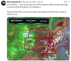
When the National Weather Service issued the warning on Monday, some online weather talent balked at the notion. “Max Velocity” (@MaxVelocityWX) on X was one of the first to complain about the warning when it was issued, downplaying the threat. Matthew Cappucci, who works for MyRadarWX, also criticized the warning. On X (@MatthewCappucci) he wrote, “It’ll get me some flack but I see so many Mid-Atlantic/East Coast warnings that make little to no sense to me. The high false-alarm rate and seemingly lowered thresholds are making questionable warnings further lose meaning.”
