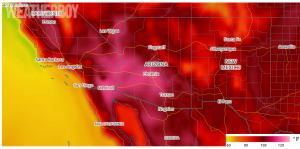
An unusually warm weather pattern has setup across the West, with hot temperatures making their way almost all the way to the coast. Extreme temperatures are not uncommon across inland areas of the southwestern United States this time of year. What is unusual about this heat wave is how early in the year the very warm temperatures are spreading to near the coast.
High temperatures on Tuesday the 20th soared into the into the 80s and 90s for locations just inland from the coast where normal high temperatures are only in the 70s and 80s. Inland, temperatures soared well into the 100s:
- Death Valley, CA 127 degrees, broke the record
- Needles, CA 125 degrees, tied the record
- Palm Springs, CA 122 degrees tied the record high for the date
- Thermal, CA 122 degrees, broke the record
- Phoenix, AZ 119 degrees, broke the record
- Redding, CA 111 degrees, broke record
- Fresno, CA 110 degrees, tied the record
- Modesto, CA 109 degrees, broke record
- Palmdale, CA 107.degrees, normal 92
- Ramona, CA 101 degrees
- Reno-Tahoe International Airport, NV 104 degrees, broke the record
- Burbank, CA 94 degrees, normal 82
- Long Beach International Airport, CA 87 degrees, normal 78

This weather pattern is expected to last for several days, right through the weekend as the ridge is not expected to move much, if at all. According to the National Weather Service (NWS) office in Los Angeles, the heat is due to “ridges of high pressure that are dominating the Southwest U.S. and keeping the jet stream north of the region over Oregon. The areas of high pressure will rotate around instead of moving on somewhere else and may even strengthen some. This will keep the scorching heat across the interior right through the weekend.”
This persistent and strong ridge of high pressure found in the low and mid levels of the atmosphere centered over the Great Basin. Surface high pressure located here causes an east wind at the coast which means dry, hot air is forced down west side the coastal mountain ranges. The marine air that keeps the region relatively cool is displaced and results in temperatures sometimes 20 degrees above normal. At the immediate coast, the marine air is always tough to displace holds on strong. From time to time, there is enough of a push of hot, dry air that can make it all the way to the coast or at least close to the coast. When this happens, the temperatures spike and records are challenged. At night, the marine layer slowly invades inland and cools areas west of the mountains off.
During the summer months, there is no hope of a cold front getting this far south and cooling things off across the interior. The only way they see some relief from the heat is a seasonal increase in moisture, called monsoonal moisture. There are signs that some of this monsoonal moisture may sneak into the interior as the orientation of the ridge of high pressure changes early next week. As the orientation of the ridge changes, the winds become more southwesterly and are able to drag some Pacific moisture northward and the increased moisture causes thunderstorms. Though these thunderstorms help cool the airmass somewhat, the threat of flash flooding (from locally heavy rain) and wildfires (from lightning strikes) rises. The monsoonal moisture is why inland areas often see the warmest average temperatures in late June or early July instead of later into July or early August when areas along the East coast see their warmest temperatures. This also disrupts the easterly winds that warm the densely-populated areas of California west of the coastal ranges and will return their temperatures to more typical levels.