Extremely critical fire weather is going to return to portions of southern California this week, with some areas expected to see conditions even worse than they were last week when fires broke out around the Los Angeles area. The National Weather Service is labeling this event a “Particularly Dangerous Situation”, with extreme fire weather conditions likely especially from 4am Tuesday through to 4am noon Wednesday.
According to the National Weather Service, widespread and high-end critical fire-weather concerns are expected as a strong upper low and easterly mid-level flow are forecast to develop off the Pacific Coast. As the upper low cuts off, mid-level flow will align with strong offshore pressure gradients over the western L.A. Basin and mountains. Offshore wind gusts to 40+ mph and single digit relative humidity values will support dangerous fire-weather conditions.
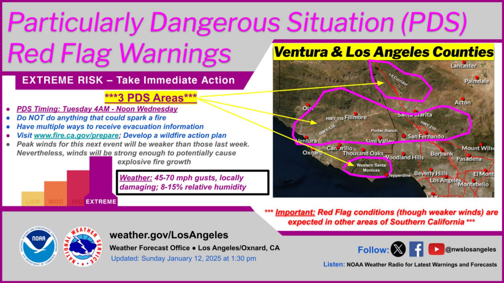
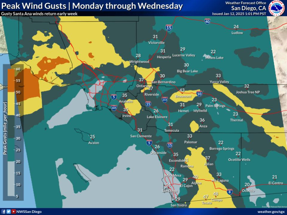
Strong northeasterly offshore winds are expected to continue intensifying overnight Monday into Tuesday. Bolstered by a strong easterly flow aloft within the cutoff low, very strong gusts of 45-70+ mph are expected in the higher terrain of the western L.A. Basin. Multiple preceding days of poor humidity recovery will exacerbate the already very dry air mass, with single digit relative humidity values expected. The rare combination of very strong winds, extremely low relative humidity, and very dry fuels will support an extended period of widespread critical fire-weather conditions over much of southern California. Extremely critical conditions are also likely across parts of Ventura County Tuesday morning where the strongest northeast winds are expected.
The National Weather Service says strong winds and critical fire concerns should continue into Wednesday morning before the upper low gradually moves farther offshore and winds aloft become more southeasterly. This shift should favor less alignment with terrain-favored corridors in the L.A. Basin. However, elevated to critical conditions will likely persist across the Santa Monica Mountains and into parts of Santa Barbra Mountains all the way through Thursday morning.
These Santa Ana winds will help to fan flames burning from uncontrolled fires in the region; any new sparks could also lead to large scale conflagration. High winds may also make it difficult or impossible for air support to fire fighting operations to continue, which could add to the worry in the region of more or greater out of control fires.
According to California Governor Gavin Newsom’s latest update, only 11% of the Palisades Fire and 27% of the Eaton Fire are contained.
