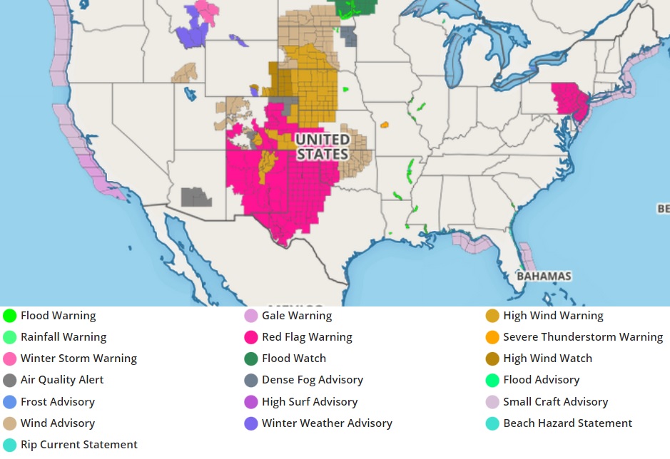
With perfect weather conditions for wildfires, the National Weather Service has issued a fresh round of Red Flag Warnings for many areas around the country today. Red Flag Warnings are now in effect for all of New Jersey and eastern parts of Pennsylvania, western Texas, most of New Mexico, southern Colorado, and western Kansas.
The combination of low fuel moisture, low relative humidity, and gusty winds may contribute to the enhanced spread of fires in the Red Flag Warning zones. A Red Flag Warning means that critical fire weather conditions are either occurring now or will shortly due to a combination strong winds, low relative humidity, and dry fuels. Any fires that develop may quickly get out of control and become difficult to contain. Because of that threat, those in Red Flag Warning areas are encouraged to follow fire safety advice from local officials; this may mean no outdoor campfires, BBQs, or even smoking.
For more more information about wildfire danger, burn restrictions, and wildfire prevention and education, the National Weather Service encourages residents to visit their state forestry or environmental protection websites.
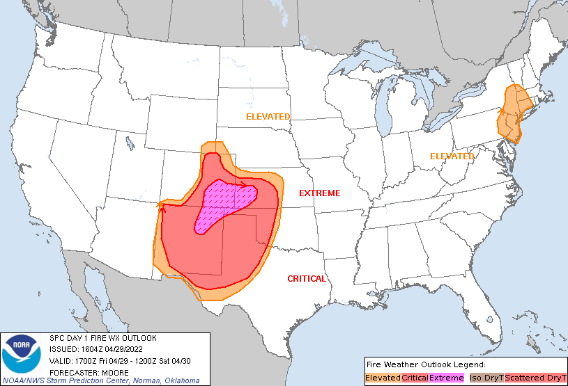
According to the National Weather Service, fire weather conditions will become more expansive from west to east through the afternoon as this subsidence spreads into the Plains. Confidence in extremely critical conditions remains highest across southeast Colorado where favorable overlap of downslope winds and a mid-level jet will support 50-60 mph wind gusts and single-digit relative humidity. Periods of extremely critical fire weather conditions are possible across the Oklahoma and Texas Panhandles and western Oklahoma this afternoon as winds gust between 30-40
mph. Gusty winds behind a front moving through the region may impact any ongoing fires too.

The National Weather Service has also expanded the elevated risk area into portions of New York, Massachusetts, Connecticut, and Vermont where the potential for several hours of elevated wind and low relative humidity conditions this afternoon has increased.
Last night’s observed soundings from the Northeast into southeastern Canada show a very dry low-level airmass. A strong upper-low off of the northeast coast will couple with a high pressure system in Canada to promote gusty offshore northwesterly winds. Fine fuels are quite dry in this region; with relative humidity falling below 20% in some locations, 15-20 mph winds will bring elevated fire weather concerns in portions of the northeast and northern Mid Atlantic.