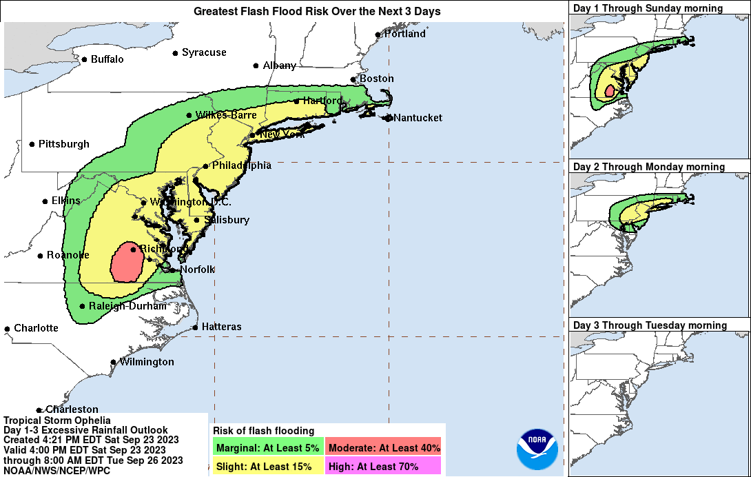
Flood and tornado threats, along with damaging wind gust hazards, persist across a large part of the Mid Atlantic in the wake of the landfall of Tropical Storm Ophelia. At 6:20 am this morning, the National Hurricane Center announced Ophelia made landfall 5 minutes earlier near Emerald Isle, North Carolina with maximum sustained winds of 70 mph. At the time, an observation station in Cape Lookout, North Carolina reported a sustained wind speed of 61 mph with a gust to 73 mph. When winds hit 74 mph, they are considered to be category 1 on the Saffir-Simpson hurricane wind scale.
Right now, Ophelia has further weakened to a tropical depression. With the system now a depression and not a storm, the National Hurricane Center dropped all Storm Surge and Tropical Storm Warnings. However, hazards remain.
As of the latest update from the National Hurricane Center, the storm was located about 40 miles south-southwest of Richmond, Virginia and about 165 miles west-southwest of Ocean City, Maryland. Maximum sustained winds are 35 mph while the minimum central pressure is 1008 mb or 29.53″. Ophelia is moving toward the north near 9 mph and a gradual turn to the northeast is expected tomorrow. On the forecast from from the National Hurricane Center, the center of Ophelia is expected to continue moving over southeastern Virginia through tonight and then over the Delarma Peninsula by tomorrow.
Up to 3-6″ of rain could fall in portions of the Mid Atlantic, with the heaviest rain over Virginia tonight and New Jersey and eastern Pennsylvania tomorrow. The latest short-range, high-resolution American NAM model suggests rain showers could linger through late Monday in the region. However, much of the heavy rain should end by tomorrow.
Latest NAM shows remnants of #Ophelia spiraling about into Monday night across portions of the northeast. pic.twitter.com/b0yVVF5ilO
— the Weatherboy (@theWeatherboy) September 23, 2023
While Storm Surge Warnings have been dropped, there is still substantial coastal flooding happening in portions of New Jersey, Maryland, Delaware, and Virginia. The National Weather Service warns: “Turn around, don’t drown; never drive through flood waters.”
While gusty, potentially damaging winds, will weaken tonight into tomorrow, there is still a threat of isolated tornadoes. The greatest risk of tornadoes is over central and southern New Jersey, eastern Pennsylvania and Maryland, and much of Delaware.
Lots of flooding from fresh water and storm surge in the Mid Atlantic today from #Ophelia.
Don’t forget: turn around, don’t drown! NEVER drive through flood waters. https://t.co/BPlPBGndoY
— the Weatherboy (@theWeatherboy) September 23, 2023