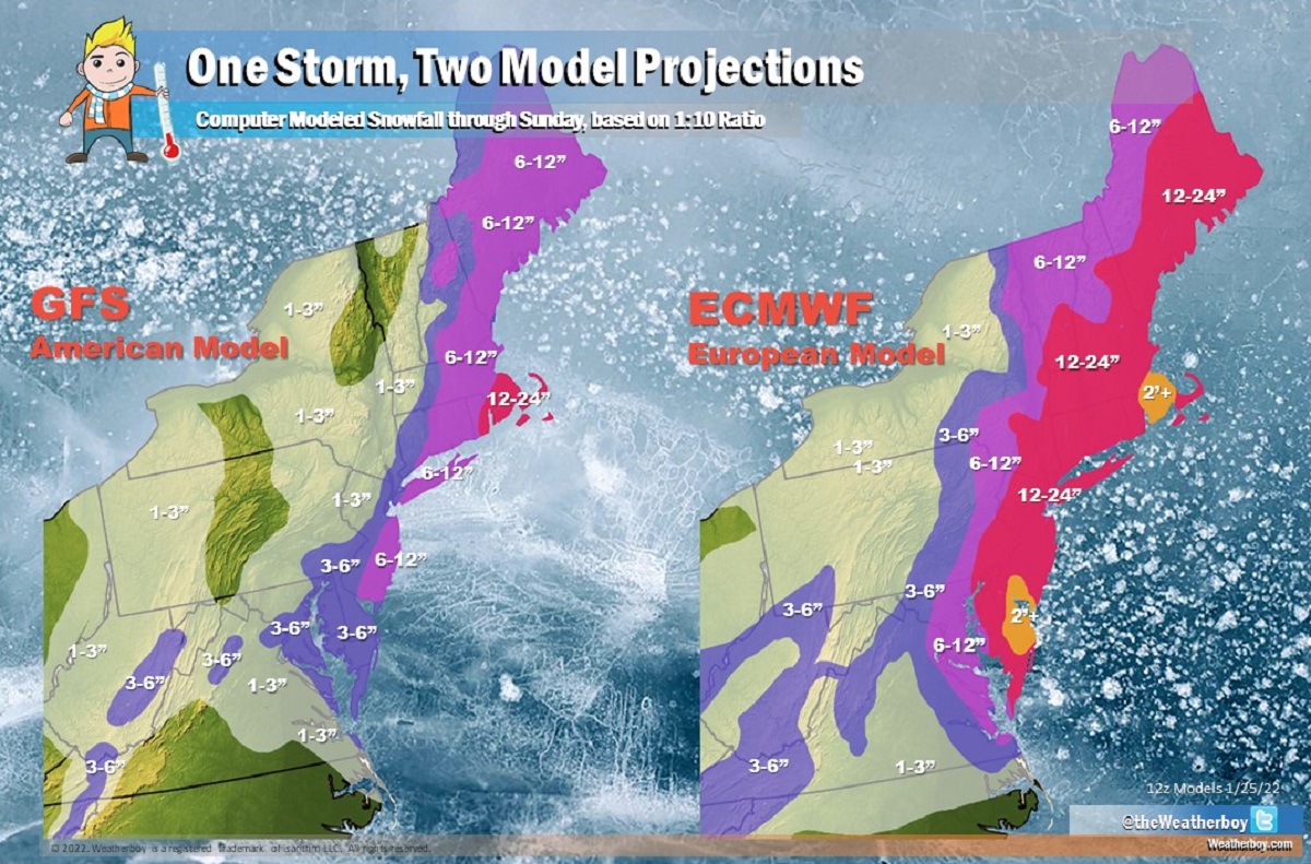
This week’s forecast features a blizzard bomb –the big question that remains: will the northeast see an actual bombing cyclone or will computer modeled forecasts be the dud that ends up bombing out? The powerhouses of the global computer forecast models that meteorologists use to aid in their forecasting show a significant winter storm off the U.S. east coast this weekend. The American GFS suggests a solution that keeps much of the storm off-shore; however, it does bring heavy snow to portions of southeastern New England and blizzard conditions beyond there. The European ECMWF suggests a solution that brings the storm closer to the coast, dumping epic amounts of snow across the I-95 corridor from Philadelphia to Boston; the ECMWF even suggests areas where more than 2 feet of snow could fall. Like the GFS, the ECMWF suggest blizzard conditions, albeit on a broader scale than its American counterpart.
While everyone knows a “bombed” forecast is a bust, not everyone knows that a “bomb” and a “blizzard” are meteorological terms with specific meanings.
While many people think a blizzard is simply a big snowstorm, they’re wrong. A blizzard is all about wind and visibility. According to the National Weather Service, three criteria must be reached before a storm is considered a blizzard. First, there needs to be sustained winds of 35 mph or frequent gusts over 35 mph. Second, due to the weather, the visibility must be reduced to 1/4 mile or less. This reduction can happen from falling heavy snow …or it could simply be previously fallen snow blowing about in the wind. You do not need fresh snow to be falling to reach blizzard criteria. Third, to count as a blizzard, the reduction in visibility and the strong winds must last for at least three hours. When all three of these conditions are met, you have more than a snowstorm: you have a full-fledged blizzard!
A “bomb cyclone” refers to the meteorological process of explosive cyclogenesis. Similar to a rapidly intensifying hurricane in the tropics in hurricane season, a bomb cyclone refers to a storm and a process in which atmospheric pressure drops quickly, the storm intensifies, with wind and precipitation increasing. In general, a bomb cyclone is a storm system that experiences a drop of at least 24 millibars (mb) within a 24 hour period.
Currently, the GFS and ECMWF global forecast models do suggest a bombing cyclone with blizzard conditions over portions of the northeast this weekend. The GFS and ECMWF are among many computer models meteorologists use to assist in weather forecasting. While meteorologists have many tools at their disposal to create weather forecasts, two primary global forecast models they do use are the ECMWF from Europe and the GFS from the United States. While the models share a lot of the same initial data, they differ with how they digest that data and compute possible outcomes. One is better than the other in some scenarios, while the opposite is true in others. No model is “right” all the time. Beyond the ECMWF and GFS models, there are numerous other models from other countries, other academic institutions, and private industry that are also considered when making a forecast.
Both of these global forecast models are projecting a major winter storm will unfold this weekend, with the criteria for a bombing cyclone and blizzard conditions at least in some areas being met. But the models are very different with their forecast solutions.
To create a robust winter storm this weekend, energy from a northern and southern stream need to phase and come together at the right location at the right time. The American GFS believes this will happen later than ideal for a blockbuster snowstorm, developing the storm later and further off-shore than the ECMWF. While the GFS yesterday afternoon suggested the timing and location would be perfect for a major impact snow storm, overnight runs reverted back to a well-off shore solution. Since then, the GFS has come a bit more west with the storm, which keeps heavy snow near and to the east of the I-95 corridor later Friday into early Sunday.
The ECMWF, on the other hand, believes the right pieces will come together at the right time and place, generating a blockbuster snowstorm, especially along the I-95 corridor from Philadelphia to Boston. It calls for widespread 1-2′ snows, with some pockets of 2′ or more possible over southwestern New Jersey, central Delaware, and northeastern Maryland ….as well as southeastern Massachusetts and eastern Rhode Island.
It is still too early to know if either model is right –or even if both are completely wrong. Vital data that’ll help meteorologists understand whether the phasing of this energy comes together at the right place/time is still about a day out from being obtained.
Until then, computer forecast models will continue to pump out potentially incredible solutions for the weekend storm. By Wednesday night or Thursday morning, meteorologists may be able to begin sharing their own accurate forecasts for this storm too.