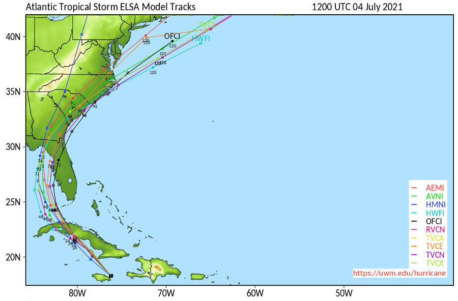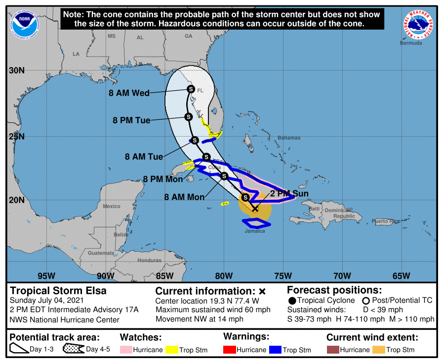
While Tropical Storm Elsa is impacting portions of Jamaica and Cuba now, eyes are on the future with its likely landfall in Florida; beyond there, computer forecast models bring the storm up the east coast, bringing wind-whipped rains from Georgia to New Jersey.
As of the last advisory from the National Hurricane Center (NHC), Elsa was located about 30 miles south-southeast of Cabo Cruz, Cuba with maximum sustained winds of 60 mph; it was moving to the north at 14 mph. The minimum central pressure was 1009 mb or 29.80″.
Widespread heavy rain will continue to affect portions of southern Haiti and Jamaica today where isolated to scattered flash flooding and mudslides will be possible. Heavy rain will then impact the Cayman Islands and Cuba today into Monday resulting in significant flooding and mudslides over Cuba. As Elsa approaches the Florida Keys and Florida Peninsula Monday through Wednesday, heavy rainfall may result in isolated flash, urban, and minor river flooding.
Tropical storm conditions and dangerous storm surge are expected with hurricane conditions possible in portions of eastern Cuba later today and tonight. Tropical storm conditions are expected in portions of central and western Cuba tonight and Monday.

Tropical storm conditions, storm surge, and rainfall impacts are expected beginning late Monday in the Florida Keys, and are possible along the coast of southwestern Florida beginning Monday night. According to the NHC, there is a risk of tropical storm conditions, storm surge, and rainfall impacts along the remainder of the Florida Peninsula Monday night through Wednesday and the coasts of Georgia and the Carolinas Wednesday and Thursday. Beyond then, more impacts could be felt in the Mid Atlantic before Elsa and its remnants move off-shore.
With severe weather imminent or likely to happen soon, a variety of watches and warnings are in effect.
A Tropical Storm Warning is in effect for the Cuban provinces of Camaguey, Granma, Guantanamo, Holguin, Las Tunas, Santiago de Cuba, Ciego de Avila, Sancti Spiritus, Villa Clara, Cienfuegos, Matanzas, Mayabeque, and Havana, all of Jamaica, and the Florida Keys from Craig Key westward to the Dry Tortugas. A Hurricane Watch is in effect for the Cuban provinces of Camaguey, Granma, Guantanamo, Holguin, Las Tunas, and Santiago de Cuba. A Tropical Storm Watch is in effect for Cayman Brac and Little Cayman, the Cuban province of Artemisa, the Florida Keys from east of Craig Key to Ocean Reef, Florida Bay, and the southwest coast of Florida from Flamingo to Bonita Beach. A Tropical Storm Warning means that tropical storm conditions are expected somewhere within the warning area. A Hurricane Watch means that hurricane conditions are possible within the watch area. A watch is typically issued 48 hours before the anticipated first occurrence of tropical-storm-force winds, which are conditions that make outside preparations difficult or dangerous. A Tropical Storm Watch means that tropical storm conditions are possible within the watch area.