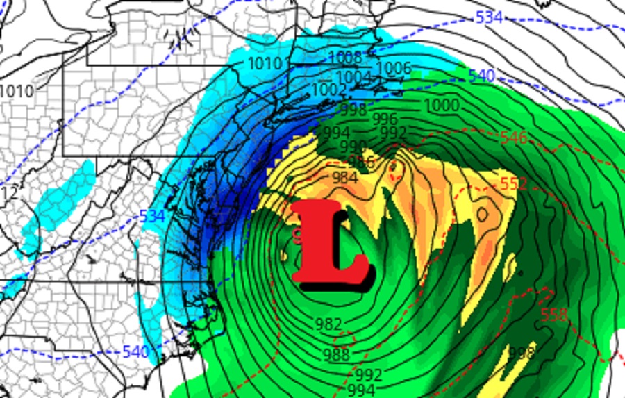
Computer forecast models used by meteorologists to aid in their weather forecasting are suggesting a major winter storm will form in the coming days, with many pondering: is the Blizzard of ’22 on the way? Major global computer forecast models have suggested that a major winter storm could form at some point between January 14 and 17 for a while; recent runs, including this afternoon’s, are becoming a bit more consistent that the wintry threat will hit around January 15 / 16 / 17 / 18 now.
Global forecast models suggesting such a storm will form include the GFS and ECMWF. The GFS and ECMWF are among many computer models meteorologists use to assist in weather forecasting. While meteorologists have many tools at their disposal to create weather forecasts, two primary global forecast models they do use are the ECMWF from Europe and the GFS from the United States. While the models share a lot of the same initial data, they differ with how they digest that data and compute possible outcomes. One is better than the other in some scenarios, while the opposite is true in others. No model is “right” all the time. Beyond the ECMWF and GFS models, there are numerous other models from other countries, other academic institutions, and private industry that are also considered when making a forecast.
Both the GFS and ECMWF are forecasting a similar scenario to unfold in the coming days. These models call for a robust short wave to travel around a long wave trough over the eastern U.S. this weekend. Both global models are in good agreement that a rapidly intensifying low will develop and pass off the Southeast coast on Sunday, moving up the Mid Atlantic and New England coasts for Monday. However, as is usually the case this far out from a storm, there is quite a bit of spread regarding the position of the storm track.
In addition between subtle differences from forecast model to forecast model, there are also model run inconsistencies from model to model. Some runs call for a storm path just far enough off-shore to bring below-freezing temperatures to the coast, which would produce heavy snow at and near the I-95 corridor in the Mid Atlantic and Northeast. Other runs are more inland, bringing milder air inland into the I-95 corridor. Such a scenario would shift the snow to the north and west of I-95, with wet or icy conditions near the I-95 corridor and the big cities that align it.
Whether or not this storm evolves into a blizzard is another big question. While most people associate heavy snow with a blizzard, it is actually strong winds that determine whether a storm is a blizzard or not. According to the National Weather Service, the criteria for reaching blizzard conditions is driven by the wind: there must be winds of at least 35 mph blowing for at least three hours; there must also be blowing or falling snow which reduces visibility to a quarter of mile or less over the same period. Due to blowing snow, sometimes blizzard criteria is met when a storm exits a region, with blowing and drifting happening with the snow left behind.
It is too soon to tell whether or not blizzard conditions would be achieved in this upcoming winter weather event. The more the area of low pressure intensifies, the more likely strong winds will whip around it. Whether or not strong wind will be present with snow that can blow and drop visibility to reach the blizzard criteria remains unknown for now and will likely remain unknown until at least 72 hours prior to the arrival of the storm.
Did someone order this? 🤔 pic.twitter.com/m8IvMriYOW
— the Weatherboy (@theWeatherboy) January 11, 2022
Bigger-picture, it is also too soon to know whether or not the modeled winter storm will actually take shape. Global forecast models present good indicators on overall storm potential about 7-14 days out; these broad signals can be narrowed down to specific storm threats about 5-10 days out; storm specifics are then flushed out into forecast specifics at about 3-5 days out. With this winter storm threat just over 5 days out, more accurate information should become available in the next 1-2 days as meteorologists, and the computers they use, digest more data to understand how the weather pattern will evolve and what storms will do in such an evolved pattern.