While portions of the Mid Atlantic and Northeast have been enjoying a bit of a thaw from a recent deep freeze and ample snow cover, some computer forecast models are suggesting that yet another significant snowstorm will impact the region later next weekend, with another heavy snow possible for New Jersey and portions of southeastern New England.
The GFS and ECMWF are among many computer models meteorologists use to assist in weather forecasting. While meteorologists have many tools at their disposal to create weather forecasts, two primary global forecast models they do use are the ECMWF from Europe and the GFS from the United States. While the models share a lot of the same initial data, they differ with how they digest that data and compute possible outcomes. One is better than the other in some scenarios, while the opposite is true in others. No model is “right” all the time. Beyond the ECMWF and GFS models, there are numerous other models from other countries, other academic institutions, and private industry that are also considered when making a forecast.
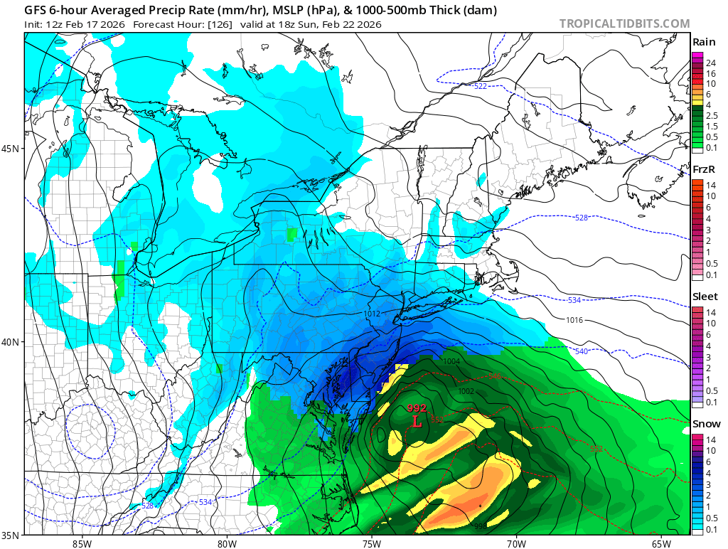
The American GFS has been suggesting that a snowstorm would form this weekend for the last few of its runs; the European ECMWF initially didn’t forecast such a system but today has also suggested the formation of a storm system in its latest run.
If the European model were to verify, there’d be snow across northern New Jersey and New York and perhaps across southeastern New England with rain falling south of there. But if the American model were to verify, this would be primarily a heavy snow storm for eastern Maryland north into coastal New England, with more than 2 feet of snow possible across portions of New Jersey and southeastern Massachussetts.
The National Weather Service in Mount Holly, New Jersey, today commented on the storm threat in their Forecast Discussion. They write, “There is the potential for yet another system towards the end of the weekend. Of the upcoming systems, this one has the highest potential to produce snowfall and more impacts. However, it is still several days out. This is still in the monitoring phase. Most global deterministic guidance has some sort of storm developing, the question remains the track. How much cold air in place also will remain a question.” They add, “Looking at some of the ensembles, there is a signal for measurable snowfall, with the GEFS probability of 4 inches or more around 10-20%. Some ensembles such as the CMC, EPS, and EPS-AIFS are more bullish which is a bit concerning. The NBM Probabilistic guidance is in the middle with 30-40% for 4 inches or more.”
Meteorologist know, including those at the National Weather Service, that forecasts from computer models are very volatile with both their deterministic and ensemble guidance more than 5 days out. Because of that, it is too early to say whether or not such a winter storm will form and what exactly its impacts would be; that would likely be better known in the next 72-96 hours.
The National Weather Service concurs, saying, “Long story short, all outcomes are on the table at the moment but it is still too early to say what level impacts are to be expected.”
Forecasters will continue to monitor computer forecast model output, the overall weather pattern, and observations to determine how the weather will unfold this weekend in the coming days.
