After a weekend that brought Tornado and Severe Thunderstorm Watches to portions of the Mid Atlantic and Northeast, it appears another day of rough weather is in the cards. While severe storms pushed through portions of the Mid Atlantic today, it appears conditions will be more favorable for even more severe weather tomorrow.
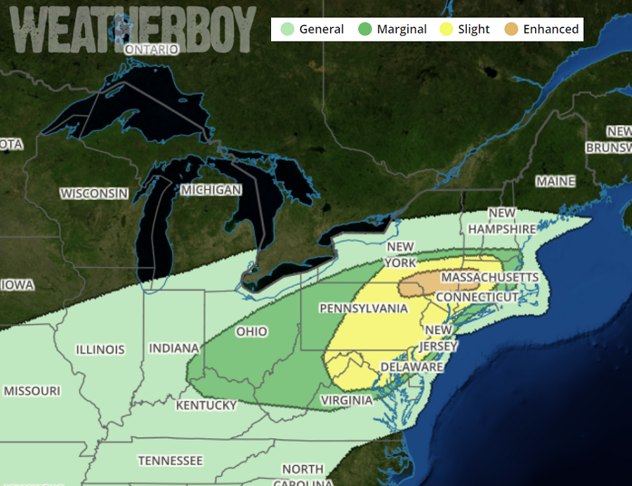
Severe thunderstorms, primarily capable of damaging winds, are forecast across parts of the Mid-Atlantic and New England Tuesday afternoon and evening. Zonal, slightly cyclonic mid-level flow will evolve across the northeast on Tuesday. Within this flow regime, a subtle but coherent impulse will advance east from the Midwest towards Pennsylvania and New York through the day. This progression should be favorably timed for boundary-layer heating to occur behind early morning precipitation and ahead of a cold front associated with the secondary impulse. Additionally, surface dew points should rise into the mid/upper 60s to near 70 from northeast Pennsylvania and New Jersey into southern and central New England by the afternoon. As a secondary wave approaches, low-level confluence and mid-level ascent are expected to focus convective development and intensification from parts of western Pennsylvania northeast to New York’s Hudson Valley. This area will also stretch into western New England. Some potential exists for enhanced and focused eastward propagation along a remnant outflow boundary from morning convection, and this, according to the National Weather Service’s Storm Prediction Center (SPC), would locally maximize the damaging wind threat. The greatest zone for this to happen is across northeastern Pennsylvania, southeastern New York, western Connecticut, and western Massachusetts.
In this same enhanced risk zone, there is also the chance for tornadoes. The SPC cautions, “While background near-surface winds will generally be veered and not particularly strong, localized backing in area valleys and/or ahead of line-embedded vortices may favor a couple of tornadoes as well.”
People in the Mid Atlantic and Northeast should make sure they know what to do should a Severe Thunderstorm or Tornado Warning be issued for their county. When a warning is issued, there may only be minutes to get to a place of safe shelter .
