• Skip to primary navigation
  • Skip to main content
  • Skip to primary sidebar

Weatherboy

Weatherboy Weather News, Maps, RADAR, Satellite, and Forecasts.

  • Local
  • Earth Science News
  • RADAR
  • Current Warnings
  • Satellite
  • Current Maps
  • Forecast Maps
  • Video

Gordon’s Remnants to Continue Flood Conditions

by Weatherboy Team Meteorologist - September 7, 2018

Gordon's remnants are expected to create excessive rainfall into portions of the Mid Atlantic in the coming days. Image: NWS
Gordon’s remnants are expected to create excessive rainfall into portions of the Mid Atlantic in the coming days. Image: NWS


While the focus may be on where Hurricanes Olivia and Florence may go, there’s a named tropical cyclone already doing damage in the U.S.: Gordon. The system was a strong Tropical Storm when it hit the Gulf Coast earlier this week. Now it’s remnants are dropping copious amounts of moisture; it is forecast to do more of the same in the Ohio Valley and Mid Atlantic in the coming days.

In the last update from the National Weather Service Weather Prediction Center, Gordon was located near latitude 35.3 North, longitude 92.0 West. Gordon is moving toward the north near 7 mph and  turn more toward the northeast tonight. Maximum sustained winds are near 10 mph. Some strengthening is forecast during the next 48 hours as the storm become increasingly extra-tropical. The estimated minimum central pressure is 1013 mb or 29.92 inches.


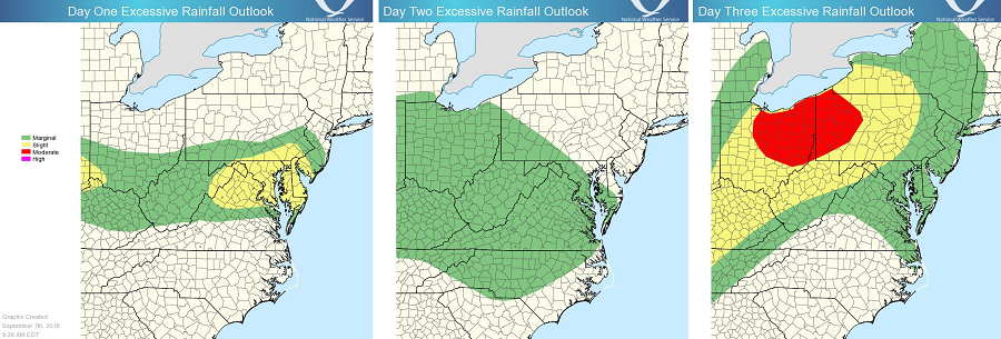
Gordon and its transition to an extra-tropical low could produce total rain accumulations of 3 to 6 inches over Missouri into the Midwest, with possible isolated maximum amounts of 10 inches through Monday. This rainfall will likely cause local flooding and flash flooding.

Over time, this flood threat will shift east, with heavy rain eventually making it to the Mid Atlantic over time. People in the excessive rain areas should prepare for the possibility of flash and river flooding. 

Primary Sidebar

Sponsored Ad

Search

Latest News

  • Volcano in Hawaii Explodes to Life, Prompting USGS to issue VOLCANO WATCH
  • Destructive Wind and Tornado Threat Today in New Jersey, Pennsylvania, Maryland, Delaware, and Virginia
  • Erick Grows Into Category 4 Hurricane, Strikes Land
  • Elevated Threat of Tornadoes Across Northeast on Thursday
  • Tropical Storm Erick Forecast to Become Strong Hurricane
  • National Hurricane Center Says Dalila is Gone But Erick Is On the Way
  • Overnight Earthquake Rocks Eastern Tennessee
  • Hot Week Ahead
About | Careers | Contact | Contests
Terms | Privacy | Ad Choices
Weatherboy is a (R) Registered Trademark of isarithm LLC, All Rights Reserved.
All content herein is Copyright by Isarithm LLC 1997-2022