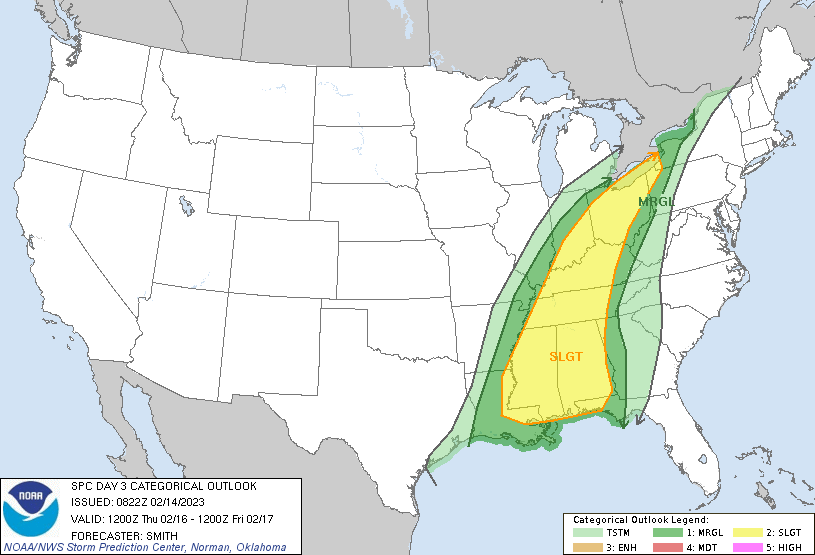
According to the National Weather Service’s Storm Prediction Center (SPC), there is a growing threat of severe weather in portions of the eastern U.S. this Thursday. Widely scattered severe thunderstorms are possible from the central Gulf Coast states northward into the Ohio Valley and Lake Erie vicinity on Thursday and Thursday evening. According to the SPC, severe wind gusts capable of wind damage and tornadoes are the primary severe hazards from this expected severe weather outbreak.
Technically, the SPC says that a large-scale, positively tilted mid-level trough will gradually move from the central Great Plains into the Desert Southwest to the Great Lakes and Ozark Plateau. A belt of intense flow will move northeast to the east of the eastward-progressing trough axis; in the low levels of the atmosphere, a surface low will migrate northeast from southeast Missouri to the Lower Great Lakes Thursday night. Meanwhile, a cold front will sweep southeastward across the lower Mississippi Valley and Ohio Valley before reaching the Appalachians. When these atmospheric ingredients come together, a severe weather outbreak is likely to unfold.
On Thursday morning, considerable shower and storm activity is expected to be ongoing from the Ohio Valley southward into the lower Mississippi Valley. Some of these storms, likely already grown upscale into lines and bands of storms, will probably pose some risk for strong, damaging gusts and perhaps a localized tornado risk, according to the SPC. The National Weather Service says they are uncertain whether or not these initial storms will continue east and re-intensify during the day; they’re also not sure if additional storms will develop in the wake of the earlier storms where some atmospheric destabilization could occur.
Residents at risk of seeing severe weather later in the week should take action to prepare for the storm. Cleaning up outside around the yard, securing things that can blow about in strong winds such as garbage cans or toys, are wise steps for people to take in the severe weather threat zones. As the severe event approaches, the National Weather Service will refine the forecast and the SPC will issue county-specific watches or warnings to alert people of the weather hazards that may form then.
