It appears that Tropical Storm Harvey, which degenerated into a wave just a few days ago in the Caribbean, is making a comeback. Harvey’s return is expected over the next 5 days, according to the National Hurricane Center (NHC.)
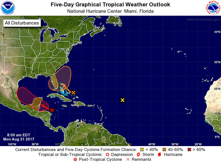
A trough of low pressure, associated with the remnants of Harvey, continues to produce a large area of disorganized showers and thunderstorms over the northwestern Caribbean Sea. Some development of this system is still possible before it reaches the coast of Belize or the Yucatan Peninsula early Tuesday. The disturbance is forecast to move into the Bay of Campeche early Wednesday, where environmental conditions are expected to be more conducive for redevelopment. Regardless of development, locally heavy rainfall and gusty winds are likely to spread westward across northern Nicaragua, Honduras, Belize, and the Yucatan Peninsula during the next couple of days.
The Air Force reconnaissance aircraft mission scheduled for today for the remnants of Harvey has been canceled. Another one may be scheduled for tomorrow.
According to the NHC, the chance of Harvey returning is 50% over the next 48 hours and a high 80% over the next five days.
While Harvey’s remnants move west, another area of concern is growing closer to the US southeast coast. A trough of low pressure located near the southeastern and central Bahamas is producing disorganized showers and thunderstorms. Environmental conditions are expected to be unfavorable for development of this system during the next day or so while it moves west-northwestward at about 15 mph across the Bahamas. But conditions could become a little more conducive for development later in the week when the system is near Florida or the adjacent waters. The NHC believes there’s a 10% chance of tropical cyclone formation here over the next 48 hours; the chances rise to 40% over the next five days.
A third area is also attracting attention over the central Atlantic; however, chance of tropical cyclone formation here is low. A large area of showers and thunderstorms located about 800 miles east-northeast of the northern Leeward Islands is associated with a surface trough that is interacting with a large upper-level low over the central Atlantic. Upper-level winds are not conducive for development of this system while it moves northwestward over the central Atlantic at 10 to 15 mph. The NHC believes there is a 0% chance of tropical cyclone formation here over the next 5 days.
Experts believe this Atlantic Hurricane Season, which runs through to the end of November, will be a busy one. Dr. Phil Klotzbach and the experts at Colorado State University updated their seasonal outlook again on July 5, showing a much more active than normal season expected. The National Oceanic and Atmospheric Administration (NOAA) also released their own forecast which shows this hurricane season to be likely more active than others.
