Hawaii could see multiple natural disaster issues in the coming days; the trouble is arriving in the form of a likely volcanic eruption and a new Kona Low disturbance, which would be the third time the rare weather system visits the state in as many weeks. While USGS has issued a Volcano Watch, the National Weather Service may issue a Flood Watch and Winter Storm Watch for the storm expected to begin during the middle of the week. In addition to heavy snow and rain, there could also be a significant downpour of tephra, which are volcanic rocks and debris, in eastern portions of the Big Island.
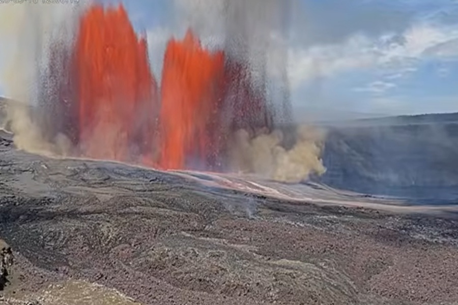
USGS has issued a VOLCANO WATCH, forecasting that an eruption will come soon to the Kilauea Volcano on the Big Island of Hawaii sometime between April 6 and 14. Volcanologists say they will fine-tune their forecast further and narrow the window of likely eruption as they process more data. In addition to the watch, a color code alert of ORANGE has been issued.
The USGS Hawaiian Volcano Observatory (HVO) is responsible for issuing Aviation Codes and Volcanic Activity Alert Levels. Aviation Codes are green, yellow, orange, or red. When ground-based instrumentation is insufficient to establish that a volcano is at a typical background level of activity, it is simply “unassigned.” While green means typical activity associated with a non-eruptive state, yellow means a volcano is exhibiting signs of elevated unrest above known background levels. When a volcano exhibits heightened or escalating unrest with the increased potential of eruption, it jumps to orange. Finally, when an eruption is imminent with significant emission of volcanic ash expected in the atmosphere or an eruption is underway with significant emission of volcanic ash into the atmosphere, the code becomes red. Volcanic Activity Alert levels are normal, advisory, watch, or warning. As with aviation codes, if data is insufficient, it is simply labeled as “unassigned.” When the volcano is at typical background activity in a non-eruptive state, it is considered normal. If the volcano exhibits signs of elevated unrest above background level, an advisory is issued. If a volcano exhibits heightened or escalating unrest, a watch is issued while a warning is issued when a hazardous eruption is imminent.
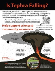
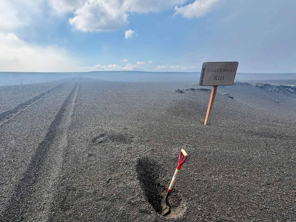
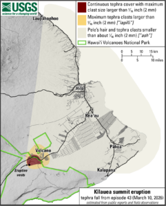
Another major hazard is fallout of Pele’s hair and other volcanic fragments from lava fountains. Pele’s hair is strands of volcanic glass often produced by lava fountaining activity that can be carried well over 10 miles (15 kilometers) from the vent. Other hot glassy volcanic fragments (tephra) including volcanic ash, pumice, scoria, and reticulite can fall on the ground within 1–3 miles (1–5 kilometers) of the eruptive vent(s), with the highest concentrations immediately downwind of the vent(s). Various volcanic fragments have fallen on Highway 11 west of Hawai’i Volcanoes National Park at times, depending on wind and eruption conditions. Strong winds may waft light particles, including Pele’s hair, to greater distances downwind. Once on the ground, Pele’s hair can sometimes cluster and tangle together, giving it the appearance of a tumbleweed. The extent of Pele’s hair deposition is dependent on lava fountaining activity and wind conditions. Residents and visitors should minimize exposure to Pele’s hair and other glassy volcanic fragments, which can cause skin and eye irritation and can also contaminate catchment water supplies
Kīlauea has been erupting episodically since December 23, 2024, primarily from two vents (north and south) in Halema‘uma‘u inside the summit caldera. Eruptive episodes, which can last up to 12 hours, are separated by pauses that can be as long as two weeks.
The Kona Low gets its name from the change in wind direction that occurs when such a storm moves over the Hawaii Islands. Hawaii is dominated by the trade winds that typically blow in from the northeast. However, the counter-clockwise flow around a Kona low located west of Hawaii results in southwesterly winds over the islands, which is typically the leeward or “Kona” side. Kona Lows are most common between October and April. These type of storms draw abundant moisture up from the warm tropical waters that surround Hawaii; when this moist flow interacts with the steep topography of the island which helps to wring-out moisture, extremely heavy precipitation can fall. Because the wind flow around a Kona Low is atypical, flooding rains occur in places that may not ordinarily flood in tropical downpours that impact the islands from time to time.
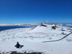
While heavy rain floods lower elevations, the higher terrain of the Big Island will see very heavy snow. While most people don’t associate the tropical paradise Hawaii is known for with snow, they’re surprised to learn that it does snow in the winter due to the elevation of its volcanic peaks. Mauna Kea is the highest of the bunch at 13,803 feet. Maui’s Haleakala is much lower at 10,023 feet. Because of that difference, Hawaii Island will see snow more frequently than the lower peak of Maui Island. Just one storm in January 2020 dropped 2-3 feet of snow on Hawaii Island and created snow drifts that were far deeper. Another storm in 2021 brought snowboarders and skiers out to the mountain by the dozens.
The National Weather Service office on the island of Oahu in the city of Honolulu has expressed concern about the atmospheric set-up expected in the coming days. In their latest forecast discussion, they wrote, “Global guidance remains in good agreement and depicts a notable amplification of the large-scale pattern across the central Pacific by Tuesday. A series of shortwave troughs digging southeastward toward the state will translate to large-scale upper height falls a cross the region. The surface ridge to the north will gradually erode as an attendant broad surface trough evolves to the west. This will disrupt the typical trade wind flow by Monday night and allow low-level winds to gradually veer out of the southeast to south Tuesday through Wednesday.”
With the transition from typical east to west trades to a southerly flow, the weather pattern will help draw deep tropical moisture northward into the islands beginning Tuesday and especially by Wednesday.
The Honolulu National Weather Service office warns, “This increasing moisture combined with daytime heating, sea breezes, and a potent shortwave trough moving through may even trigger some heavy showers over interior areas on Tuesday.” They add, “Confidence is increasing that the second half of the week may present the highest potential for widespread rainfall and flooding impacts across the state. During this time, upper-level forcing is expected to strengthen as a strong shortwave rounds the base of the trough, potentially enhancing lift over the region while low pressure organizes west of the islands. The combination of deep moisture, increasing large-scale forcing for ascent, and gusty southerly winds favors a transition toward a more widespread and organized rainfall event.”
In addition to a heavy rain threat, there’s also a risk of severe thunderstorms and damaging winds, especially with gusts from down-sloping winds for north and windward sides of the islands.
As the heavy rain hits the Big Island, the colder summits of Mauna Kea and Mauna Loa could support significant snowfall accumulations. Depending how the precipitation spreads into the Big Island, there could be 6″ or more of snow there.
What makes this next storm worse is the Aloha State is still recovering from two significant Kona Low systems that soaked the islands with rainfall measured in some cases in feet versus inches. The consecutive March storms were responsible for over $1 billion in damages in the state, with agricultural losses estimated to be as high as $70 million with 1,600 farms impacted, especially on hard hit islands of Oahu and Hawaii (Big Island.) Over 400 homes were destroyed or damaged in the state.
The National Weather Service recommends people take this action now before the storm arrives:
– Clear gutters, storm drains, culverts, and drainage areas of debris to improve water flow
– Move valuable items out of low-lying or flood-prone areas
– Check pumps, generators, and emergency equipment to ensure they are operational
– Take stock of emergency supplies, including food, water, medications, flashlights, and backup power sources
– Review family emergency plans and check on neighbors and family, especially those in flood-prone locations
“Residents living near streams, rivers, gulches, valleys, ravines, and flood-prone areas should remain especially alert and be prepared to move to higher ground if flash flooding develops,” the National Weather Service says.
But with a Kona Low system and another volcanic eruption happening at the same time, the National Weather Service has additional advice: “If an eruption occurs, varying levels of ash, Pele`s hair, and other lightweight tephra may fall downwind of the eruption. Smaller particles can travel farther from the eruption site and may affect communities at greater distances.” They also add, “If you live downwind of the Kilauea summit, or plan to visit the summit area, stay informed about current volcanic activity and weather conditions. Be prepared to take precautions if needed, such as disconnecting water catchment systems. Follow all guidance from the National Park Service and the County of Hawaii. Be aware
that road or park closures may occur.”
