Hawaii is shaking, with an earthquake striking every few minutes on the Big Island as the Kilauea Volcano there is exhibiting signs of increased unrest. While the volcano is not currently erupting, that could change quickly.
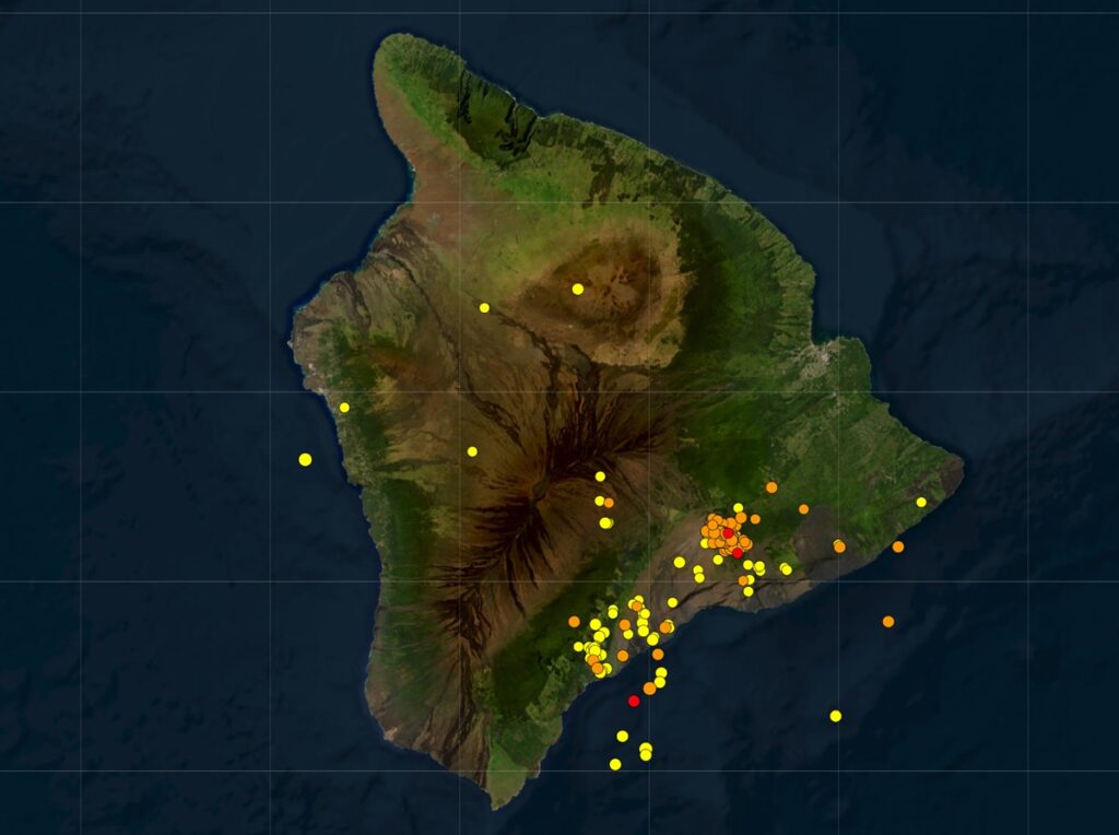
According to USGS and the Hawaiian Volcano Observatory (HVO), a seismic swarm that began on June 27 beneath the upper East Rift Zone, just southeast of the summit region, escalated in intensity last night, though the earthquake rate has eased slightly this morning. There were no significant changes in ground deformation associated with this escalation of seismicity, but longer-term inflation of the summit and upper rift zones has persisted since the end of the June 3, 2024, eruption.
“Any substantial increases in seismicity and/or deformation could result in a new eruptive episode, but there are no signs of an imminent eruption at this time,” scientists with HVO shared in a morning update today.
There were over 500 earthquakes detected beneath the upper East Rift Zone and surrounding areas over the past 24 hours, mostly at depths of 1–1.8 miles. Seismicity was already elevated as part of a swarm that began on June 27, then the earthquake rate further escalated late yesterday, reaching a peak of approximately 30 events per hour around midnight. The largest of these earthquakes were four magnitude 3.0 events that occurred near the intersection between Chain of Craters Road and Hilina Pali Road in Hawaii Volcanoes National Park, at similar depths to the rest of the swarm. This morning, the earthquake rate has slowed to approximately 20 earthquakes per hour, which still represents heightened unrest compared to before the June 27 swarm.
There were no obvious changes in ground deformation associated with the escalation of seismicity, but slowing inflationary tilt over the past few days has transitioned to slight deflationary tilt: instruments at Uēkahuna northwest of the summit and at Sand Hill southwest of the summit respectively recorded approximately 7 microradians and 2 microradians of net deflation over the past 24 hours. GPS instruments around the summit region continue to show slow, longer-term inflation since the end of the June 3, 2024 eruption.
When magma accumulates beneath the ground, causing the surface above to inflate, the slope of adjacent areas will usually tilt away from the center of uplift. Conversely, if the ground deflates as a consequence of magma draining from a subsurface reservoir, the slope of adjacent areas will tilt toward the center of subsidence.
Based on HVO analysis, following the last eruption on June 3, 2024, magma has been repressurizing the storage system beneath Halemaʻumaʻu and the south caldera region, activating earthquakes in the upper East Rift Zone and in the caldera south of Halemaʻumaʻu.
“At this time, it is not possible to say whether this increase in activity will lead to an intrusion or an eruption in the near future, or simply continue as seismic unrest at depth, “HVO said. “With the earthquake rate easing slightly this morning, there are no signs of an imminent eruption at this time,” they added.
Previous eruptions and intrusions beneath the upper East Rift Zone have occurred in the vicinity of Pauahi Crater and Hiʻiaka Crater to the southeast of the summit, and around Luamanu and Keanakākoʻi Craters at the margin of the summit caldera. This region erupted several times during the 1960s–1970s; the most recent eruption took place over a single day in November 1979 within and near to Pauahi Crater.
“Currently, there is no indication that magma is moving towards the June 3, 2024, eruption site southwest of the caldera. However, changes in the character and location of unrest can occur quickly, as can the potential for eruption,” HVO scientists cautions.
For now, scientists are putting the volcano at an “ADVISORY” alert level while the current aviation color code is “YELLOW.”
In the U.S., the USGS and volcano observatory units are responsible for issuing Aviation Codes and Volcanic Activity Alert Levels. Aviation Codes are green, yellow, orange, or red. When ground-based instrumentation is insufficient to establish that a volcano is at a typical background level of activity, it is simply “unassigned.” While green means typical activity associated with a non-eruptive state, yellow means a volcano is exhibiting signs of elevated unrest above known background levels. When a volcano exhibits heightened or escalating unrest with the increased potential of eruption, it jumps to orange. Finally, when an eruption is imminent with significant emission of volcanic ash expected in the atmosphere or an eruption is underway with significant emission of volcanic ash into the atmosphere, the code becomes red. Volcanic Activity Alert levels are normal, advisory, watch, or warning. As with aviation codes, if data is insufficient, it is simply labeled as “unassigned.” When the volcano is at typical background activity in a non-eruptive state, it is considered normal. If the volcano exhibits signs of elevated unrest above background level, an advisory is issued. If a volcano exhibits heightened or escalating unrest, a watch is issued while a warning is issued when a hazardous eruption is imminent.
