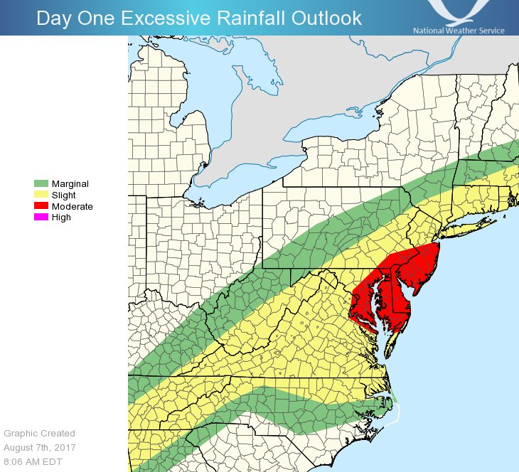
Another round of heavy rain and severe thunderstorms are expected in the Mid Atlantic today. The threat of heavy rain is anchored over New Jersey, Delaware, southeastern Pennsylvania, and northeastern Maryland while the threat of severe storms are anchored a bit further south over southern Delaware, southeastern Maryland, eastern Virginia, and northeastern North Carolina. The heavy rain threat has prompted the National Weather Service to issue flood advisories for the region, with severe weather watches and warnings likely as storms fire-up in the daytime heating later today.
Water vapor imagery from weather satellites shows a shortwave trough moving across Kentucky and Tennessee this morning. Widespread showers and thunderstorms have been ongoing overnight ahead of the trough across much of West Virginia, Virginia, and western Maryland. This activity will spread eastward through the morning hours, with a marginal threat of a few strong wind gusts. In the wake of the morning convection, it appears likely that skies will partially clear over parts of Virginia, Maryland, and northeast North Carolina prior to the mid-level
shortwave trough passage. With just enough sunshine leading to atmospheric instability there, a risk of a few supercells capable of damaging wind gusts and/or an isolated tornado or two. The threat should move offshore shortly after dark.
With an abundance of atmospheric moisture to work with, more heavy rain is likely to fall in and just above this severe weather threat zone. With grounds soaked and streams and rivers running high from other recent heavy rain, the National Weather Service has issued Flash Flood Watches for Long Island, New York City, central and southern New Jersey, southeastern Pennsylvania, all of Delaware, eastern Virginia and Maryland, and Washington, DC.
People in flood threat areas should remember: turn around, don’t drown; never drive through flooded roadways.
