• Skip to primary navigation
  • Skip to main content
  • Skip to primary sidebar

Weatherboy

Weatherboy Weather News, Maps, RADAR, Satellite, and Forecasts.

  • Local
  • Earth Science News
  • RADAR
  • Current Warnings
  • Satellite
  • Current Maps
  • Forecast Maps
  • Video

Heavy Rain Threat Arrives Next Week

by Weatherboy Team Meteorologist - June 15, 2019

More heavy rain is expected in areas that don't need it in the coming days, making flooding conditions worse. Image: NWS
More heavy rain is expected in areas that don’t need it in the coming days, making flooding conditions worse. Image: NWS


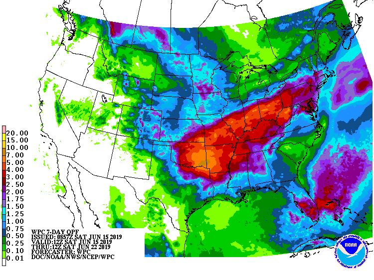
Another round of heavy rain is expected across portions of the Mid West and Mid Atlantic, making existing flooding problems worse while creating new ones further east. More than 5″ of rain is possible over the next 7 days over portions of Oklahoma, Arkansas, Missouri, Illinois, Indiana, Ohio, and West Virginia. Portions of New Jersey, Pennsylvania, Maryland, Delaware, and Connecticut could see over 2.5″.

The large-scale pattern for much of the Sunday to Thursday period will feature a relatively fast and quasi-zonal mid/upper flow from the central Plains to the East Coast south of a longwave trough in eastern Canada. Several low-amplitude perturbations will progress eastward in the faster midlevel flow atop a quasi-stationary front from the Midwest and Ohio Valley east-northeast to the Mid-Atlantic and New England. To the south of the front, low-level warm/moist advection will continue through the period to the west of a broad subtropical ridge in the western Atlantic located between the southeastern U.S. and Bermuda. As the flow meets the quasi-stationary front and midlevel perturbations, bouts of convection will initiate and propagate along the surface front. Computer forecast guidance suggests this front will stall from Oklahoma to the Ohio Valley, leading to a prolonged wet period.


With rain forecast to fall over the same areas over and over again, flooding threats will increase throughout the week. The National Weather Service reminds people in these areas: turn around, don’t drown; never drive through flood waters.

Primary Sidebar

Sponsored Ad

Search

Latest News

  • Earthquake Strikes Near Charleston, South Carolina where Worst East Coast Quake Struck
  • After Weather Delay, New Mechanical Issue Delays NASA’s Moon Mission
  • Earthquake Rattles Illinois Near St. Louis, Missouri
  • Groundhog Agrees with Climate Prediction Center: Many More Week of Winter Ahead
  • Massive X-Flare Explodes from Sun on Sunday Evening
  • East Coast Snow Storm Exits Coast With 20″+; Even Florida Got Snow
  • Another Wintry Weekend with Winter Storm Warnings & Extreme Cold Warnings
  • Afternoon Earthquake Rumbles Through New Jersey
About | Careers | Contact | Contests
Terms | Privacy | Ad Choices
Weatherboy is a (R) Registered Trademark of isarithm LLC, All Rights Reserved.
All content herein is Copyright by Isarithm LLC 1997-2022

Insert/edit link

Enter the destination URL

Or link to existing content

    No search term specified. Showing recent items. Search or use up and down arrow keys to select an item.