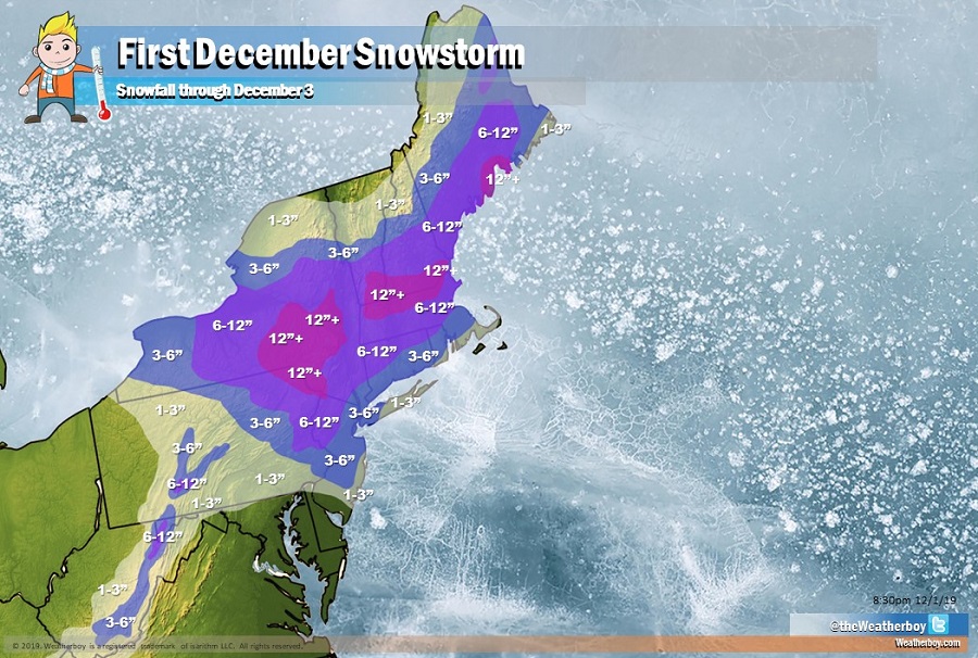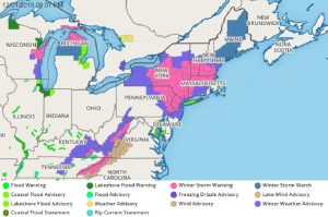
Heavy snow from a potent early-season winter storm will drop more than a foot of snow across portions of the northeast on Monday. With the southern portion of the storm system looking more robust than it did earlier, it appears heavier than initially expected snow will fall over portions of eastern Pennsylvania and central and southern New Jersey. Due to changes with the forecast, the National Weather Service has responded too, expanding Winter Storm Warnings and Winter Weather Advisories further south too.
With the first part of the storm over, which was responsible for rain, ice, and snow across portions of the northeast today, people are preparing for the main event tomorrow. Late tonight towards morning, colder air will filter into northeast Pennsylvania, sufficiently cooling low-level thermal profiles to result in a transition from mainly liquid precipitation to sleet/snow in the Poconos and vicinity. This will spread southeastward into the Lehigh Valley and adjacent areas by daybreak. Accumulations will be fairly limited overnight, but the transition may be fairly quick, with precipitation rates increasing rapidly thereafter. Travel impacts to the morning commute may be significant northwest of the Fall Line during/after precipitation transition. South of the I-76/I-295/I-195 corridors, precipitation will remain in liquid form over the nighttime hours but turn to snow during the day on Monday. North if I-80, precipitation will remain as snow tonight and continue into tomorrow, heavy at times.

During the day tomorrow, an upper and mid-level low will be positioned over Philadelphia metro region. This combined with low pressure intensifying just offshore along the Jersey Shore will result in an area of frontogenesis across the northern Mid Atlantic. Because of these dynamics, it is becoming likely that a deformation band of precipitation extending from eastern New York down across eastern Pennsylvania, northern New Jersey, and into portions of central and southern New Jersey will occur during the day. This band will be very narrow and there remains considerable uncertainty in where exactly it’ll set-up. It’s placement could mean the difference of 1″ of snow versus 7″ of snow within a 5 mile distance.
With this heavy band expected to form over eastern Pennsylvania, it is now expected the Philadelphia metro area will see 3-5″ of snow, with heavier amounts on the north side of Philadelphia County and places north, with much less on the south side of Philadelphia County near Philadelphia International Airport. 3-6″ is now expected over interior southern New Jersey, much of central New Jersey, and the New York City metro area. An inch or two, or an isolated 3″ amount, is also possible elsewhere along the Jersey Shore from Atlantic City north, eastern Long Island, and extreme southeastern New England. While the system could end as snow over Cape Cod, Martha’s Vineyard, and Nantucket, not much in the way of accumulations is expected there. North and west of the I-95 corridor, even heavier snow is expected, with 6-12″ amounts likely from northeastern Pennsylvania and northwestern New Jersey into central New England. More than a foot of additional snow is expected for portions of central and eastern Upstate New York, southern Vermont and New Hampshire, and northern Massachusetts. Central and southern Maine away from the northern Canadian border will also see moderate to heavy snow.
Driving along and to the north of the I-95 corridor from Philadelphia to Boston will become difficult at times on Monday. Air travel at PHL, EWR, JFK, LGA, BOS, ISP, and TTN airports is already being impacted with numerous delays and cancellations and more are expected tomorrow. People that can postpone travel are urged to do so. Those in Winter Storm Warning areas are advised not to travel at all. If you’re in a Winter Storm Warning area, the National Weather Service encourages you to bring warm extra clothes, food, water, back-up batteries, and a flashlight in case you become stranded in the heavy snow.
Temperatures on Monday will fall into the mid 30s across much of the northern Mid Atlantic and then fall into the 20’s Monday night; temperatures will be 5-15 degrees colder north of there. It is because of these falling, cold temperatures that liquid precipitation will change to snow on Monday.
While some lingering snow is possible along the coast Tuesday morning as the back edge of precipitation works its way through the region, most precipitation will end from southwest to northeast late Monday night into early Tuesday morning. As the storm system heads east of Cape Cod on Tuesday, weak high pressure will build across the northeast late Tuesday and Tuesday night.