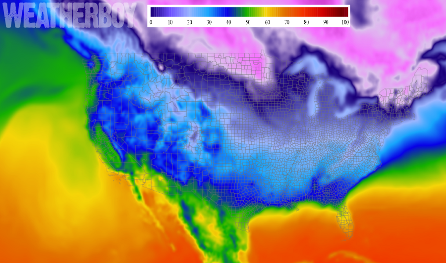
The period between Christmas and New Years can be cold in the United States and the 2017 holiday season is no exception, with a solid cold blast impacting a large part of the country. Arctic high pressure centered over the Northern Plains continues to build east today.
A weak low pressure system will move off the Southeast US coast this afternoon; it will interact with a mid-level shortwave and a jet streak moving through the Mid Atlantic and Northeast this evening. This interaction will lead to the development of a stronger low pressure system with snow showers developing, but the bulk of this snow on land will fall over northern North Carolina and southern Virginia, but even there, the snow will be light. Even more snow will fall over the ocean, impacting mariners there.
North of this low, conditions will be dry and fair. As the Arctic air mass presses east, the center of the high will shift into the Greak Lakes and Ohio Valley. This will help bring an end to Lake Effect snows, some of which have totaled more than 5 feet around Erie, Pennsylvania. Strong subsidence ahead of the high moving into the Northeast and Mid Atlantic will help clear out skies and help to diminish winds there too.
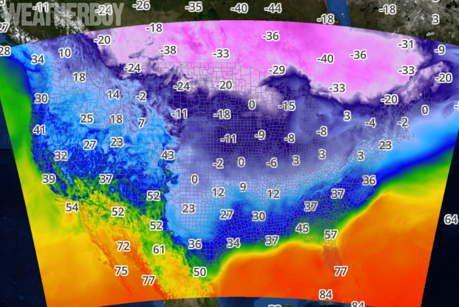
It will be a very cold night, even around the heavily populated I-95 corridor in the northeast. Overnight lows will drop into the teens along the I-95 corridor from Trenton to Philly to Wilmington, and into the Delmarva, but otherwise will range from 5-10 above for most of southeast Pennsylvania and central and southern New Jersey. For north and west of the Fall Line, lows will range from 0 to 5 above, and from 5 below to around 0 in the Poconos. Temperatures will drop close to 0 in upstate New York and interior southern New England too. Wind chills will mostly range from 5 below zero to 5 above zero, except for the Poconos, where wind
chills will generally be as low as 15 below. Because of those winds in the Poconos, the National Weather Service has issued a Wind Chill Advisory there for Carbon and Monroe counties.
Arctic high pressure will continue to pour into the region with cold air at the end of the week and for the weekend. Unusually cold air will spill into the start of 2018 too. Readings will be 10 to 20 degrees below normal for late
December/early January, with the coldest days being tomorrow and next Sunday through Tuesday.
Meteorologists continue to monitor the threat for northeast snowstorms between December 29 and January 5; important data from the Pacific and Northern Canada late tonight should arm meteorologists with needed insights to better understand how the storm threat will evolve for the upcoming weekend and start of the New Year.
