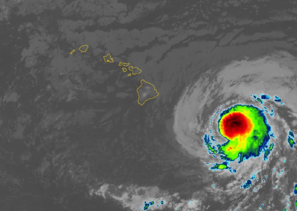
Tropical Storm Hone is likely to intensify into Hurricane Hone soon as it passes near the Hawaiian Islands; dry windy conditions ahead of it on the leeward sides of the islands set the stage for fires to spread on the islands of Maui and Hawaii on Friday. Due to the threats from the tropical cyclone, a Tropical Storm Warning is up for the entire Big Island of Hawaii while a Red Flag Warning for fire weather conditions has been posted for the leeward sides of all the major islands in the state.
As of the latest advisory from the Central Pacific Hurricane Center (CPHC) in Honolulu, Hawaii on the island of Oahu, Hone’s maximum sustained winds have increased to 65 mph. It is located about 290 miles east-southeast of Hilo and 500 miles east-southeast of Honolulu. The storm is moving to the west-northwest at 15 mph while the minimum central pressure is 998 mb or 29.47″.
With the rain and wind field from Hone expected to lash Hawaii Island even with the center passing to its south, the CPHC has issued a A Tropical Storm Warning for Hawaii County which consists of the entire Big Island of Hawaii. A Tropical Storm Warning means that tropical storm conditions are expected somewhere within the warning area within 36 hours.
Hone is moving toward the west near 15 mph. This motion slightly north of due west is expected to continue over the next several days with a gradual decrease in forward speed. On the forecast track, the center of Hone is expected to pass near or south of the Big Island tonight into early Sunday.
Maximum sustained winds measured by Hurricane Hunter Aircraft are near 65 mph with higher gusts. According to the CPHC, strengthening is forecast during the next 48 hours, and Hone is expected to be a hurricane Sunday through Monday southwest of the Big Island of Hawaii. Tropical-storm-force winds extend outward up to 115 miles from the center now.
Tropical storm wind conditions are expected in the warning area as early as Saturday afternoon and continuing into Sunday. Winds are expected to be strongest where they blow downslope from higher terrain, over headlands, and through passes.
Hone is expected to produce storm total rainfall of 5-10″ over mainly windward and southeast facing slopes of the Big Island, with locally higher amounts possible. Rainfall totals of 2-4″ will be possible over portions of the smaller islands, mainly windward sides there too.
Swells generated by Tropical Storm Hone will begin impact eastern portions of the Hawaiian Islands later tonight, then spread to the remainder of the state through the rest of the weekend. These swells will produce life-threatening surf and rip currents.
The conditions ahead of Hone are also dry and windy, setting the stage for fire weather conditions. Because of this set-up, the National Weather Service in Honolulu has issued a Red Flag Warning, which is in effect from 10 am to 6 pm on Saturday, across the leeward portions of all Hawaiian Islands. Northeast 30 to 40 mph with localized gusts up to 50 mph, humidity as low as 40 percent, and dry fuels can contribute to extreme fire behavior. “Any fires that develop will likely spread rapidly, ” the National Weather Service warns. A Red Flag Warning means that critical fire weather conditions are either occurring now or will shortly. A Red Flag Warning does not predict new fire starts.
Fires erupted in the dry conditions on the Big Island of Hawaii and Maui on Friday. Near the town of Waikoloa Village on Hawaii’s Big Island, firefighters worked to contain a wildfire that consumed more than 20 acres. While residents of Waikoloa Village were on edge with the fire burning near their community, no evacuations were needed and no residential or commercial structures were threatened by the fire that consumed mainly invasive, flammable grasses. On Maui, a fire broke out along the Kuihelani Highway. Maui Fire Department fought that fire which closed numerous roads there including Kuihelani Highway at Waiko Road and Honoapiilani Highway. The smoke is reportedly impacting visibility on Kuihelani Highway which led to its closure. The threat of fire could linger until quenching rains arrive; however, due to drying, downslope winds on the leeward sides of the islands, very little rain may fall in those fire prone areas.