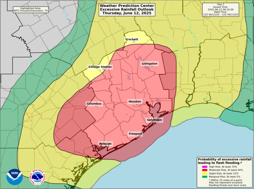
The National Weather Service’s Weather Prediction Center (WPC) has identified the broader Houston metro area as ground zero for an ongoing flooding event which began yesterday. The WPC says that flash flooding is ongoing and is expected to continue today across portions of southeast Texas, especially where a Moderate Risk (level 3/4) of Excessive Rainfall is in effect.
“Be sure to plan ahead if traveling and never drive through flooded roadways,” warns the National Weather Service.
After soaking rains and thunderstorms impacted the region yesterday, the next round of storms is ongoing across southeast Texas. The National Weather Service cautions that some embedded storms could become strong to severe while localized heavy rain, with rates as high as 3”/hour, are also a possibility. They say they are monitoring parts of the upper Brazos and Trinity watersheds for potential rises to bankfull or flood stage in places where they aren’t already.
Currently, a Flood Watch is in effect for a large majority of Southeast Texas, and is coincident with a moderate risk (threat level 3 of 4) for excessive rain. Flash Flood Warnings are in effect from Matagorda Bay northeastward across most of Matagorda County. Flood advisories are in place for the upper portions of the Houston Ship Channel and Baytown northwestward to IAH Airport and Kingwood.
The National Weather Service office for Houston/Galveston does see an end in sight though. “Late this afternoon or this evening, we’ll see this round of storms make their way off to the east, and we will get another short break until we move into the next opportunity for storms late tonight into Friday,” forecasters with the office wrote in their latest Forecast Discussion.
While the Atlantic Hurricane Season began on June 1, today’s heavy rains are not related to any tropical disturbance. Soaking rains do impact Texas this time of year; on this date in 1973, as an example, Columbus, Texas recorded 13.67″ of rain while Liberty recorded 11.49″.
This event’s rain totals won’t be as significant as the 1973 event though. Additional rainfall amounts of 2-5″ are expected with isolated amounts of 6-7″+.
“Stay weather-aware and be prepared to take action should flooding develop,” warns the National Weather Service. “If you encounter flooded areas, please, turn around, don’t drown.”
