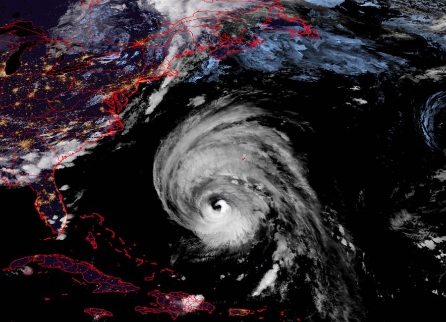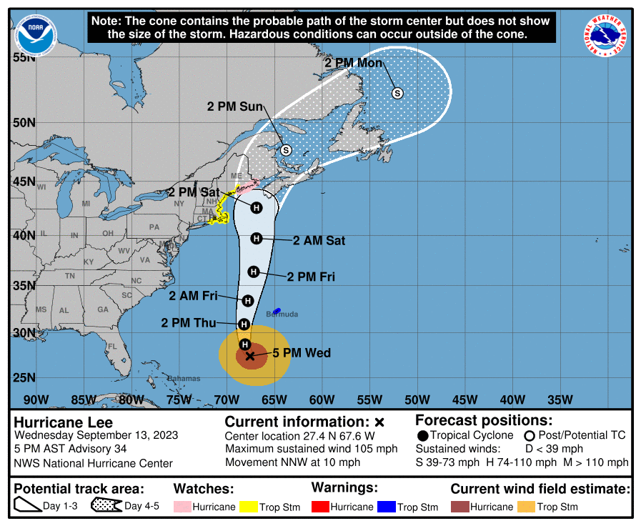
The National Hurricane Center has issued Hurricane and Tropical Storm Watches for portions of the northeast coast due to the forecast of Lee heading that way. Environment Canada, the Canadian equivalent of the U.S. National Weather Service, is also urging residents in Atlantic Canada to be ready for impacts from the hurricane this weekend. The Canadian Hurricane Centre unit from Environment Canada hasn’t issued any advisories for Canada yet but likely will soon.
While Hurricane Lee is forecast to weaken, it will become a larger storm as it heads north with a very large shield of rain and wind. As such, where the center of the storm travels isn’t as important because a large, wide area will see severe impacts from the storm.
As of the latest advisory from the National Hurricane Center (NHC), Lee was located about 380 miles south-southwest of Bermuda and about 965 miles south of Nantucket, Massachusetts. Maximum sustained winds were 105 mph. The storm is moving to the north-northwest at 10 mph. Barometric pressure is at 952 mb or 28.12″.
A Hurricane Watch has been issued for portions of down-east Maine from Stonington to the U.S./Canada border. A Tropical Storm Watch has been issued for a large area of coastal New England from Watch Hill, Rhode Island to Stonington, Maine, including Block Island, Martha’s Vineyard and Nantucket. A Storm Surge Watch has been issued for Cape Cod Bay and Nantucket, Massachusetts. A Tropical Storm Warning is in effect for Bermuda. A Hurricane Watch means that hurricane conditions are possible within the watch area. A watch is typically issued 48 hours before the anticipated first occurrence of tropical-storm-force winds, conditions that make outside preparations difficult or dangerous. A Tropical Storm Warning means that tropical storm conditions are expected somewhere within the warning area, in this case within the next 24 hours. A Tropical Storm Watch means that tropical storm conditions are possible within the watch area, generally within 48 hours. A Storm Surge Watch means there is a possibility of life-threatening inundation, from rising water moving inland from the coastline during the next 48 hours.
While Lee is moving to the north-northwest now, the NHC expects it to turn toward the north and an increase in forward speed later tonight into Thursday and Friday. On the forecast track, the center of Lee will pass west of Bermuda Thursday and Thursday night and then approach the coast of New England and Atlantic Canada Friday and Saturday.
Hurricane-force winds extend outward up to 115 miles from the center and tropical-storm-force winds extend outward up to 265 miles.
Tropical storm conditions are expected in Bermuda starting early Thursday. Hurricane conditions are possible in portions of down-east Maine on Saturday. Tropical storm conditions are possible in portions of coastal New England within the Tropical Storm Watch area beginning Friday night.

The combination of storm surge and tide will cause normally dry areas near the coast to be flooded by rising waters
moving inland from the shoreline. The water could reach the following heights above ground somewhere in the indicated areas if the peak surge occurs at the time of high tide:
-Chatham, MA to Sagamore Beach, MA: 2-4′
-Cape Cod Bay: 2-4′
-Nantucket: 2-4′
-Sagamore Beach, MA to Border of US/Canada: 1-3′
-Boston Harbor: 1-3′
-Flushing, NY to Chatham, MA: 1-3′
-Montauk Point, NY to Flushing, NY: 1-3′
-Long Island Sound” 1-3′
-Martha’s Vineyard: 1-3′
-Rockaway Inlet, NY to Montauk Point, NY: 1-2′
The deepest water will occur along the immediate coast where the surge will be accompanied by large and destructive waves. Surge-related flooding depends on the relative timing of the surge and the tidal cycle, and can vary greatly over short distances.
Swells generated by Lee are affecting portions of the Lesser Antilles, the British and U.S. Virgin Islands, Puerto Rico, Hispaniola, the Turks and Caicos Islands, the Bahamas, Bermuda, the east coast of the United States and are beginning to reach Atlantic Canada. These swells are likely to cause life-threatening surf and rip current conditions. Even expert swimmers and surfers should avoid the ocean until hazards from Lee completely pass.
Outer rain bands from Lee could produce rainfall amounts of 1-2″ across Bermuda Thursday into early Friday.
From Friday night through Saturday night, Lee is expected to produce rainfall amounts of 1-4″ across portions of eastern New England into portions of New Brunswick and Nova Scotia. This could produce localized urban and small stream
flooding.
Environment Canada warns, “Our latest assessment is that western Nova Scotia and southern New Brunswick stand to see the most wind while western New Brunswick northward into parts of the Bas-St-Laurent and Gaspesie regions of Quebec are at risk of the heaviest rainfall. High waves and elevated water levels will be more widespread due to the large size of the storm – the most impacted areas likely covering much of the Atlantic coast of mainland Nova Scotia and the Fundy coast of New Brunswick.