After a few weeks of quiet in the tropics, that is now all changing with Hurricane Bonnie on the way and several more tropical cyclones possible within the next two weeks. With a new tropical cyclone in the process of forming in the Atlantic Basin, Tropical Storm Warnings have just been issued.
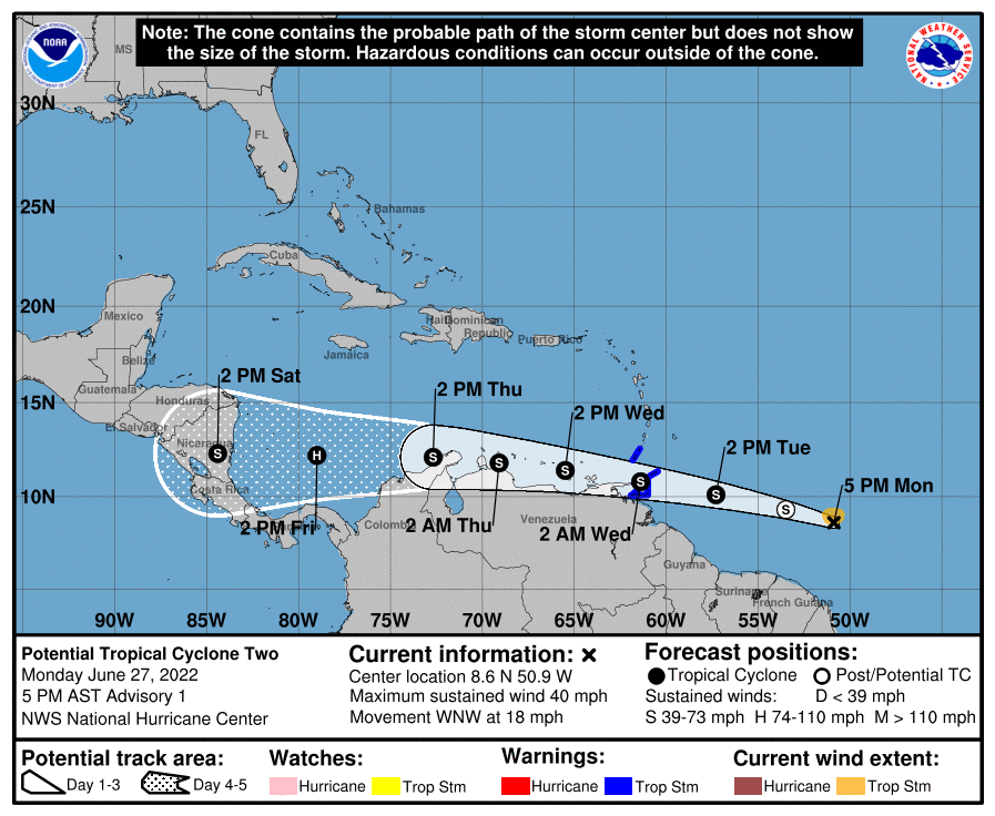
A NOAA Hurricane Hunter aircraft investigated a tropical wave to the east-southeast of the Windward Islands and found that the system has not yet developed a closed circulation. However, the plane did find an area of tropical-storm-force winds over the northern portion of the system. The disturbance is producing some cells of strong convection, but overall the system is not very well organized. That aside, the National Hurricane Center (NHC) believes there is a good chance that the disturbance will become a tropical storm before reaching the southern Windward Islands, prompting them to issue advisories on what they’ve labeled “Potential Tropical Cyclone Two.” The NHC wrote in the latest Tropical Forecast Discussion that the environment looks fairly favorable for development, but the numerical guidance is generally not as bullish on strengthening for the next couple of days. Nevertheless, the NHC forecast officially brings this disturbance to Category 1 hurricane status by Friday afternoon.
Then this disturbance reaches tropical storm status, the National Hurricane Center will name it “Bonnie.”
With formation likely, Tropical Storm Warnings are now in effect for Trinidad and Tobago and for Grenada and its dependencies. A Tropical Storm Warning means tropical storm conditions are expected in the warning area within 36 hours.
At this time, it appears Bonnie, as either a Tropical Storm or Hurricane, will be a threat primarily to the Windward Islands, the ABC Islands of Aruba, Bonaire, and Curaçao, the northern coasts of Columbia and Venezuela, and eventually portions of Central America in or around Honduras, Nicaragua, and Costa Rica. The storm is expected to stay south of the rest of the Caribbean, the Bahamas, Cuba, and the southeastern United States through its existence.

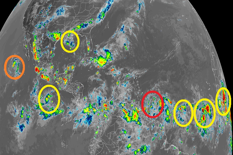
The same may not be true for the systems behind it. Looking more like hurricane season in the middle of August than the end of June, weather satellite photography from NOAA’s GOES-East shows many possible systems that could develop into tropical cyclones with time, and some of those systems could threaten the United States. Of the bunch of prospects, the National Hurricane Center is carefully tracking two.
The first of the two systems is a disorganized area of showers and thunderstorms over the north-central Gulf of Mexico. This disturbance is associated with a trough of low pressure in the area. According to the NHC, some slow development of this system is possible while it moves west-southwestward at about 10 mph and approaches the coasts of southern Texas and northeastern Mexico during the next few days. Formation odds remains relatively low for now though: the NHC says there’s only a 10% chance that a tropical cyclone will form here over the next 48 hours; over the next 5 days, those odds rise somewhat to 20%.
The second system being monitored by the NHC is a tropical wave located several hundred miles southwest of the Cabo Verde Islands. This evening, this system is producing disorganized showers and thunderstorms. The NHC says that environmental conditions could become conducive for some gradual development later this week while the system moves west-northwestward at around 15 mph over the central tropical Atlantic. As with the first system, the NHC believes there’s only a 20% chance that this system will become a tropical cyclone over the next five days.
The Atlantic Hurricane Season started on June 1 and continues through to the end of November. Leading scientists believe this will be another especially busy season again.