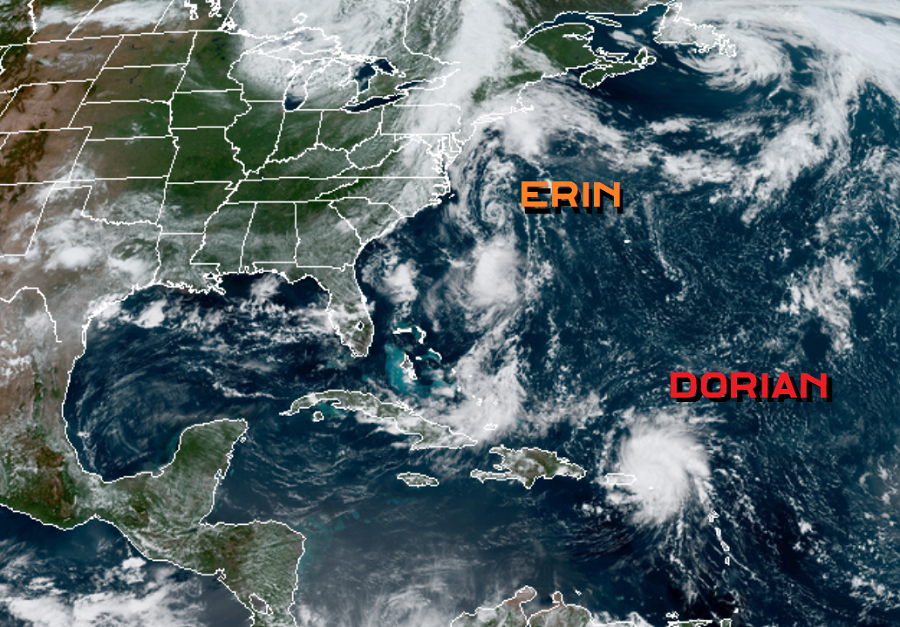
Tropical meteorology experts at the National Hurricane Center (NHC) in Miami, Florida this afternoon upgraded Tropical Storm Dorian to hurricane status this morning. While impacts to Puerto Rico and the Virgin Islands are imminent, there’s growing concern that Dorian will intensify to major hurricane status before making landfall on the U.S. East Coast.
A variety of warnings and watches are now in effect for Hurricane Dorian. A Hurricane Warning is in effect for Vieques and Culebra, the U.S. Virgin Islands, and the British Virgin Islands. A Hurricane Watch is in effect for all of Puerto Rico while a Tropical Storm Warning is now in effect for the entire island. A Hurricane Warning means that hurricane conditions are expected somewhere within the warning area, in this case within the next 6 to 12 hours. A Hurricane Watch means that hurricane conditions are possible within the watch area, in this case within the next 6 to 12 hours.
As of the latest advisory issued by the NHC, the center of Hurricane Dorian was located near latitude 18.3 North, longitude 65.0 West. Dorian is moving toward the northwest near 13 mph, and this motion is expected to continue for the next day or two. On this track, Dorian should continue to move near or over the U.S. and British Virgin Islands this afternoon and then move over the open Atlantic well east of the southeastern Bahamas.
Maximum sustained winds have increased to near 75 mph with higher gusts. According to the NHC, Dorian is forecast to continue strengthening during the next few days over the Atlantic waters. Hurricane-force winds extend outward up to 20 miles to the north and east of the center. Tropical-storm-force winds extend outward up to 80 miles primarily to the east of the center. An elevated weather station on Buck Island just south of St. Thomas reported a sustained wind of 82 mph and a gust of 111 mph. The estimated minimum central pressure from nearby observations is 997 mb or 29.44 inches of mercury.
Heavy rain, strong winds, and rough surf are all expected from Hurricane Dorian. Dorian is expected to produce 1-3″ of rain in the Northern Leeward Islands, 1-3″ in Eastern Puerto Rico, 4-6″ with isolated amounts up to 10″ in the Virgin Islands and the northwest Bahamas, 2-4″ in Western Puerto Rico and the central Bahamas, and the possibility of 4-8″ with isolated amounts of 10″ when the storm arrives in the United States over the weekend. All of these amounts could produce life-threatening flash floods. Mud and rock slides are also possible on mountainous terrain in the Caribbean. Hurricane conditions are ongoing over portions of the U.S. Virgin Islands, and are expected over Vieques, Culebra, and the British Virgin Islands today. Tropical storm conditions are expected in Puerto Rico this afternoon and tonight. Wind speeds atop and on the windward sides of hills and mountains are often up to 30 percent stronger than the near-surface winds and in some elevated locations could be even greater. Swells are expected to increase later today across the U.S. and British Virgin Islands and along the southern coasts of Puerto Rico and Hispaniola, and they could cause life-threatening surf and rip current conditions.
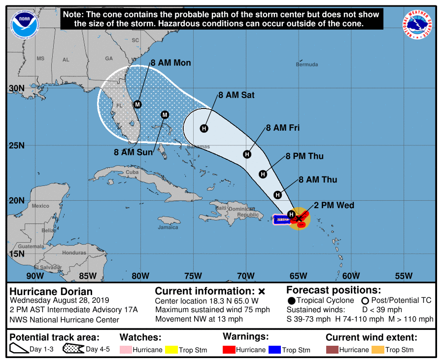
The official forecast track from the National Hurricane Center projects an east coast landfall of Dorian as a major hurricane around the morning of Labor Day. It is important to point out that track and intensity forecasts can see significant error this far out; people anywhere along the U.S. East and Gulf Coasts should closely monitor the future track of this system in the coming days as the holiday weekend approaches.
The most recent hurricane to make landfall on Florida’s East Coast was Hurricane Katrina in 2005 as a Category 1 storm. It would later enter the Gulf of Mexico and destroy portions of the coast including New Orleans. The most recent major hurricane landfall on the Florida east coast was Jeanne in 2004.
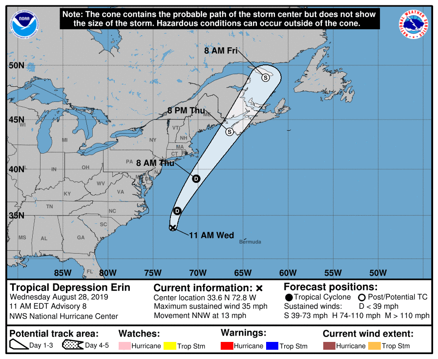
While Dorian is forecast to become a major hurricane over time, Erin is losing steam. The storm briefly became a tropical storm last night but has since weakened to a tropical depression. The center of Tropical Depression Erin was located near latitude 33.6 North, longitude 72.8 West in the last advisory issued by the NHC. The depression is moving toward the north-northwest near 13 mph. The cyclone is expected to turn northward later today and then north-northeastward early Thursday morning with an increase in forward speed. Maximum sustained winds are near 35 mph with higher gusts. Little change in strength is forecast through tonight although the NHC believes the system could strengthen as an extratropical low on Thursday. The estimated minimum central pressure is 1006 mb or 29.71 inches of mercury. While rough surf and rip currents could be created by this system, especially along the Mid Atlantic and New England coastline, no direct impacts are expected from Erin.
