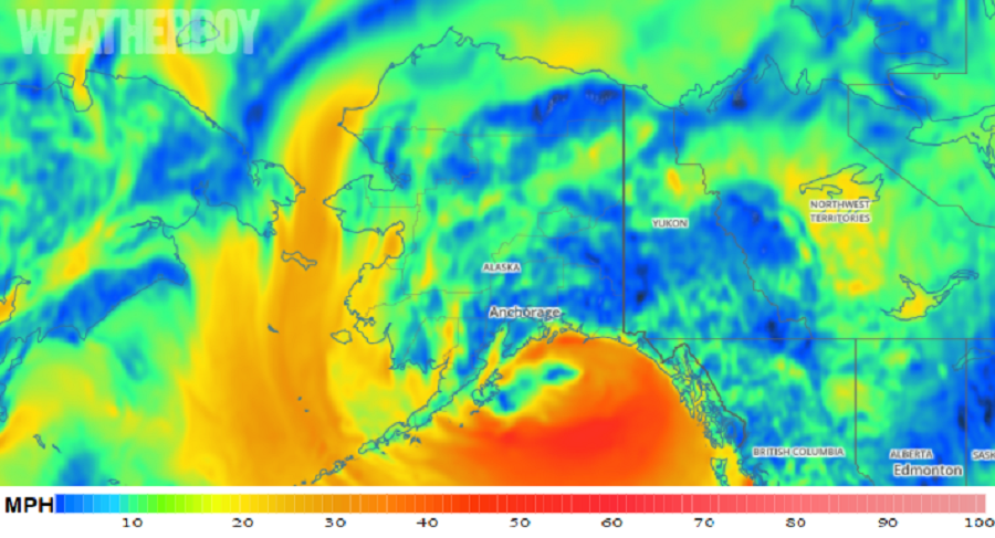
While the tropics are quiet in the waters around Hawaii, the Gulf Coast, and the U.S. East Coast, a non-tropical cyclone is expected to bring hurricane-like conditions to a large part of the central Alaska coast tonight and tomorrow. The robust cyclone will enter the Gulf of Alaska, producing wind-whipped heavy rain for the area. With hurricane force winds expected, the National Weather Service has issued Hurricane Force Wind Warnings for coastal of the Northern Gulf of Alaska Coast up to 100 nautical miles out, including Kodiak Island and Cook Inlet.
For now, models and satellite imagery show occlusion happening much sooner than was expected yesterday, with a weak triple point low now expected to form later tonight. This low will track around the northern to western side of the main low center, passing east of Kodiak Island on Sunday. This will lead to stronger winds over all of the western Gulf and Cook Inlet coastal waters on Sunday.
As far as rainfall, Kodiak Island and the Eastern Kenai/Western Prince William Sound will be the focus of heaviest rain with this storm system. The presence up the triple point low will enhance rainfall for Kodiak City, though no flooding is expected. Rainfall elsewhere will be lighter and initially confined to the coastal zone. By Monday, the low is forecast to come onshore somewhere in the vicinity of Cordova, with rain spreading north and west across the Copper River Basin. Gusty southerly winds will move in behind the low and spread onshore of the Gulf coast/Prince William Sound on Monday.
While rain falls at the coast, a rain/snow mix is expected to continue through the Ahklun and Kilbuck Mountains as well as the Kuskokwim Valley. The best chances of snow are in the Ahklun and Kilbuck Mountains as observations show afternoon temperatures ranging from 29F in the Kilbuck Mountains between 1900-2000ft to 33F in the Kilbuck Mountains between 400 500ft. The rain/snow mix should taper off by tonight from southeast to northwest. Little to no snow accumulation is expected.
Temperatures should remain steady or slowly rise tonight into Sunday as a warm occlusion occurs. This is a process in which warmer air wraps around the northern side of the low as the low in the Gulf moves in from the northeast. Due to the forecast warming of the air aloft, the chances for snow significantly decrease on Sunday.
In addition to soaking rains and strong winds, rough surf will also batter the coast. Off-shore seas should be around 5 feet this evening and increase to 13 feet after midnight. Tomorrow into tomorrow night, they should be 20-25 feet. As the storm winds down, seas should subside to around 16 feet on Monday and 12-14 feet by Monday night.
