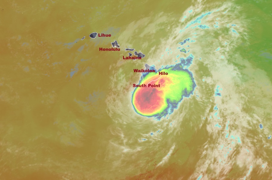
Hurricane Hone continues to lash Hawaii with torrential rains and damaging winds as the first tropical cyclone in the Central Pacific Hurricane Season heads west just south of the Aloha State. At 4 am HST / 10 am ET this morning, Hurricane Hone reached its closest point of approach to the Big Island of Hawaii passing approximately 45 miles south-southwest of South Point, Hawaii.
As of the latest update from the Central Pacific Hurricane Center, Hurricane Hone continues marching west south of the main Hawaiian Islands. Hone is moving toward the west near 10 mph and this motion is expected to continue into Monday, followed by a slight decrease in forward speed thereafter. Maximum sustained winds were measured by an Air Force Reserve reconnaissance aircraft near 80 mph with higher gusts. The Central Pacific Hurricane Center expects a gradual weakening trend to begin late this afternoon onward.
Hurricane-force winds extend outward up to 15 miles from the center and tropical-storm-force winds extend outward up to 115 miles.
Deep tropical moisture associated with Hone continues to move into windward portions of the Big Island and is currently producing near 1-2″ per hour rates within the strongest rain bands, creating widespread flash flooding. Rainfall duration and intensity is expected to increase during the overnight hours. Based upon surface observations and radar estimates, the windward areas of the Big Island have already picked up 2-3″ with some amounts over 6″ of rain from Hone over the past 6 hours. This moisture will expand westward to all islands through early next week as Hone passes to the south of the state, increasing the potential for heavy statewide rainfall and threat for localized flash flooding. Generally 6-12″ of rain wil fall on the Big Island, with locally higher amounts; the heaviest rains will continue to fall on the windward side of the island.
Strong and gusty winds associated with the storm will continue to impact Big Island, with widespread gusts of 50 to 60 mph through the local exposed valleys and higher elevations such as Kohala Ranch, Humuula Saddle, Upolu Point, and Waikoloa through Sunday afternoon. The strongest gusts are expected around South Point, as well as downslope of Mauna Kea, Mauna Loa, and the Kohala Mountains. Localized gusts could reach as high as 70 mph. Northeast winds around the northern side of Hurricane Hone will strengthen across the rest of the state through Sunday. Strong downslope winds will also occur over downwind, leeward slopes through Sunday night. Wind gusts to 50 mph along the higher elevations and leeward communities of other islands are possible too.
With the winds that have already hit the state, tens of thousands of people are in the dark with widespread power outages on Hawaii Island. Trees have been blown down, blocking some roads throughout the island too. A full damage assessment will be made at first light when calmer conditions return.
Deep tropical moisture associated with Hone will keep local relative humidity levels high. This increase in humidity, with the rainfall, has significantly decreased the fire weather threat. Because of that, Red Flag Warnings that had been up prior to the storm’s arrival have been dropped.
