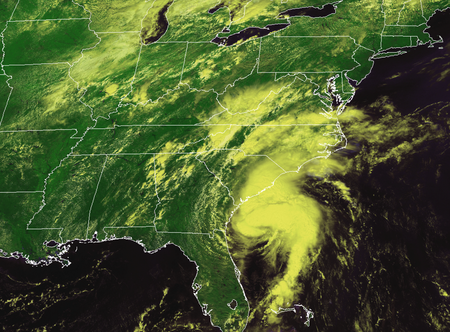
The National Hurricane Center expects Isaias to strengthen to a hurricane prior to making landfall on the Carolina coast this evening. With impacts expected tonight and tomorrow up much of the East Coast north of the Carolinas, additional watches and warnings have been issued.

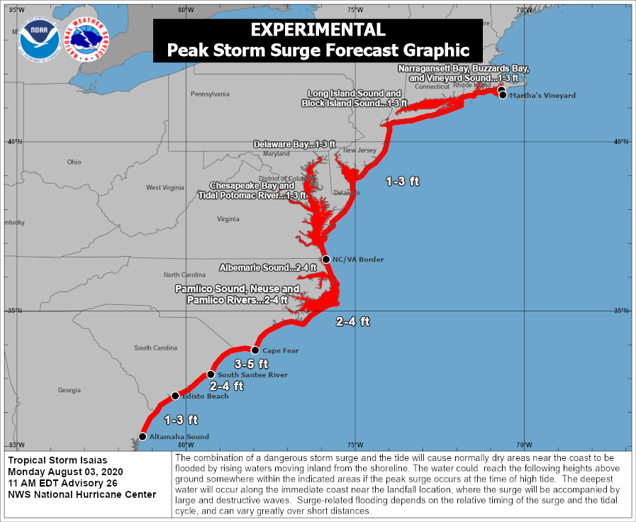
A Storm Surge Warning is in effect for the area between Edisto Beach, South Carolina to Cape Fear, North Carolina, both the Pamlico and Albemarle Sounds, including the Neuse and Pamlico Rivers, and from the Oregon Inlet in North Carolina to the North Carolina/Virginia border. A Storm Surge Watch is in effect in North Carolina from Cape Fear to Oregon Inlet. A Storm Surge Warning means there is a danger of life-threatening inundation, from rising water moving inland from the coastline, during the next 36 hours in the indicated locations. The National Hurricane Center warns, “This is a life-threatening situation. Persons located within these areas should take all necessary actions to protect life and property from rising water and the potential for other dangerous conditions. Promptly follow evacuation and other instructions from local officials.” A Storm Surge Watch means there is a possibility of life-threatening inundation, from rising water moving inland from the coastline, in the indicated locations during the next 48 hours. With higher than usual tides due to the lunar cycle, storm surge flooding could be worse than it normally would be in this type of storm.
A Hurricane Warning is in effect from the South Santee River in South Carolina to Surf City, North Carolina. A Hurricane Warning means that hurricane conditions are expected somewhere within the warning area, in this case within 24 hours. Preparations to protect life and property should be rushed to completion.
A Tropical Storm Warning is in effect for large portions of the U.S. East Coast. The warning area includes Altamaha Sound in Georgia to the South Santee River in South Carolina; north of Surf City, North Carolina to the Mouth of the Merrimack River in Massachusetts. This warning area includes the Pamlico and Albemarle Sounds, Chesapeake Bay, Tidal Potomac River, Delaware Bay, Long Island and Long Island Sound, Martha’s Vineyard, Nantucket, and Block Island. A Tropical Storm Watch is in effect north of there from the Mouth of the Merrimack River to Eastport, Maine. Tropical Storm Warnings also extend inland in the Mid Atlantic and southern New England, and include the cities of Philadelphia, New York City, Baltimore, Washington, DC, Hartford, Providence, and Boston. A Tropical Storm Warning means that tropical storm conditions are expected somewhere within the warning area, generally within 36 hours; a Tropical Storm Watch means that tropical storm conditions are possible within the watch area, generally within 48 hours.
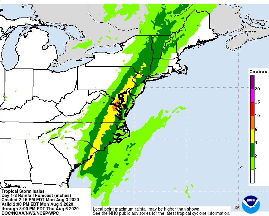
In addition to severe winds, Isaias will produce extremely heavy downpours that will lead to significant flood issues for many. The heaviest rain from the storm will fall over eastern Virginia, central and eastern Maryland, and eastern Pennsylvania. Because of the structure of the storm and the expected evolution of it, less than 1″ of rain is expected along portions of the Jersey Shore, Long Island, and southeastern and eastern New England. While these areas won’t see the heaviest rain, they will see some of the strongest winds. Some areas in the heaviest rainfall zone could see 6-10″ or more of rain in a very short period of time. This will lead to life-threatening flash flooding that could turn tranquil streets into raging rapids. The National Weather Service continues to warn: “Turn around, don’t drown; never drive through flood waters.”
Beyond fresh water flooding from rain, the coast will be dealing with inundation from storm surge. A large portion of the East Coast will see storm surge with this storm and some surge could be 2-4 feet in portions of North Carolina, which is enough to inundate homes, businesses, and roads near the coast. If asked to evacuate by local officials, they should do so immediately. Storm surge flooding will impact tidal waterways even away from the ocean, including the Potamac River near Washington DC, the Delaware River near Trenton and Bordentown in New Jersey, and the Raritan Bay in New Jersey.
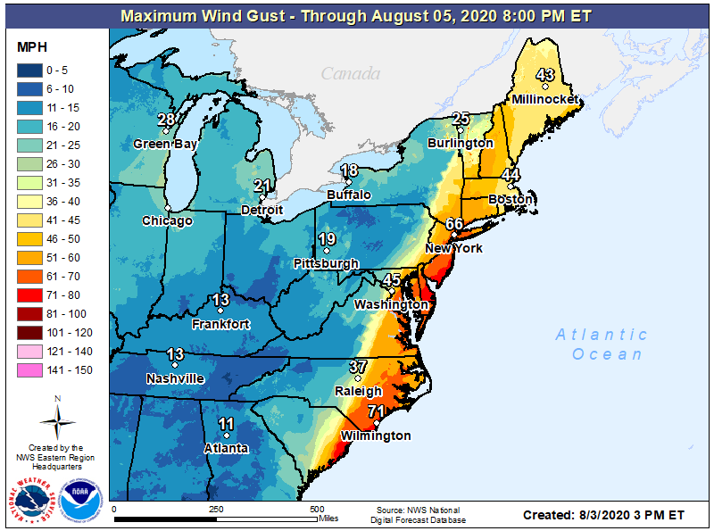
There is also a threat of tornadoes and waterspouts from this storm as there are with most landfalling tropical cyclones. This tornado threat exists across eastern portions of South and North Carolina, Virginia, and Maryland, Delaware, New Jersey, Long Island, and portions of New England south and east of I-95.
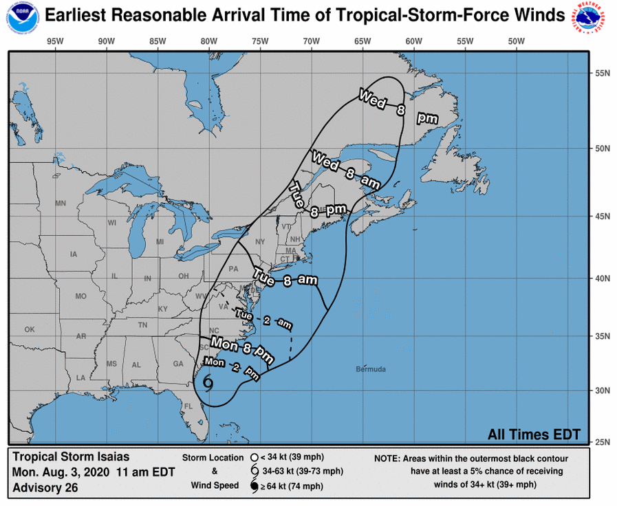
After making landfall over the Carolinas, Isaias will move up the Mid Atlantic and New England regions as a strong tropical storm. The storm will pick up forward speed as it moves north. It will also become somewhat lopsided as it moves north, with most rain and wind north of the center with little weather impacts south of the center. As an example, when the center of circulation arrives in central New Jersey by lunchtime Tuesday, much of the rain south of central New Jersey across southern New Jersey, eastern Maryland, and Delaware will be over. Winds will also diminish behind the storm from south to north throughout the day. The storm should be out of the United States completely by Tuesday night, with northeastern Canada next to feel its impacts late Tuesday night into Wednesday. While there will be typical summertime, isolated pop-up thundershowers and storms in the northeast on Wednesday, most should experience fair conditions.
