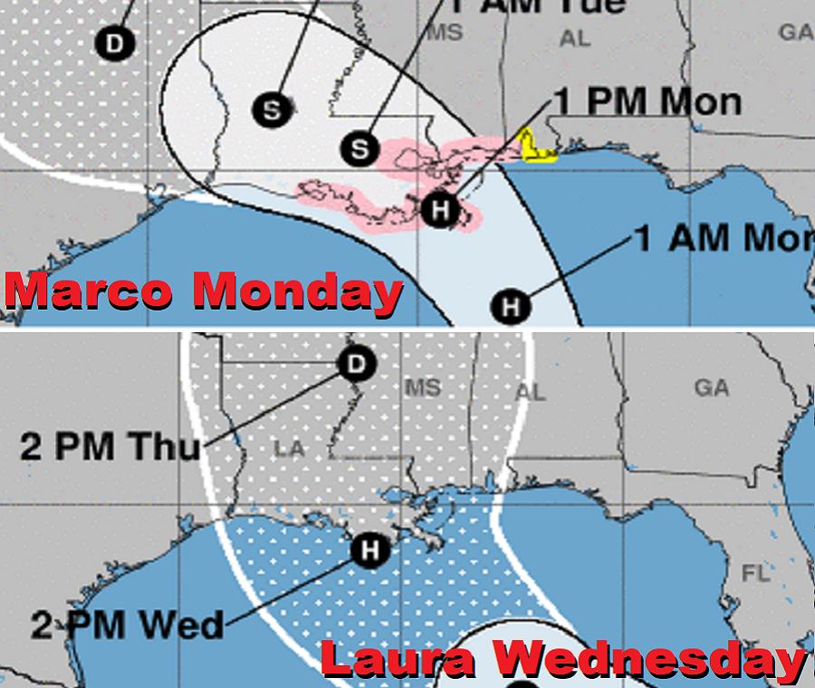
While forecasts can and will change, the latest update this evening from the National Hurricane Center brings a Hurricane Marco to the Louisiana coast on Monday and a Hurricane Laura within the same general area (+/- 75 miles) just two days later on Wednesday.
In a surprising update from the National Hurricane Center at 5pm ET today, they shifted the forecast for Marco significantly east, bringing the center over or near the metropolitan New Orleans area on Monday. Because of that, Storm Surge and Hurricane Watches were issued for portions of the U.S. Gulf Coast.
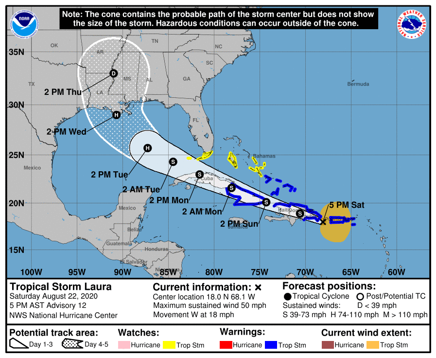
Meanwhile, Tropical Storm Marco is currently passing through Puerto Rico. It is forecast to pass through Hispaniola and Cuba, perhaps cut through the Florida keys, and intensify further as it enters the Gulf of Mexico. Based on that path, new Tropical Storm Watches and Warnings have been issued.
A Tropical Storm Watch has been issued for the Florida Keys from Ocean Reef to Key West and for the Dry Tortugas, including Florida Bay. The government of Cuba has issued a Tropical Storm Warning for the
Cuban provinces of Camaguey, Las Tunas, Holguin, Guantanamo, Santiago de Cuba, and Granma. The government of the Bahamas has issued a Tropical Storm Watch for Andros Island. A Tropical Storm Warning means that tropical storm conditions are expected somewhere within the warning area. A Tropical Storm Watch means that tropical storm conditions are possible within the watch area, generally within 48 hours.
The National Hurricane Center doesn’t expect significant changes in strength during the next 48 hours while Laura moves near or over Hispaniola and Cuba, but that is expected to change as it enters warmer Gulf of Mexico waters. Until then, Puerto Rico and the Virgin Islands will see 3-6″ of rain with isolated amounts near 8″; the Dominican Republic and Haiti will see 4-8″, with maximum amounts of a foot of rain possible across southern areas. Cuba will see 3-6″ of rain with isolated areas of 8″. All of this heavy rainfall could lead to life-threatening flash and urban flooding, and the potential for mudslides across the Greater Antilles. Widespread minor to potential moderate river flooding is possible in Puerto Rico.
Tropical storm wind conditions are expected within portions of the warning area today through Sunday. Tropical storm conditions are possible within portions of the watch area Sunday night and Monday.
After organizing over the Gulf of Mexico, the latest forecast track from the National Hurricane Center brings Laura over Louisiana on Wednesday, within 72 hours of the landfall of Hurricane Marco. This will be the first time on record two hurricanes will be in the Gulf of Mexico at the same time, but it won’t be the shortest time between two continental U.S. landfalling hurricanes. That happened on September 4-5, 1933 when two Category 3 hurricanes hit.
The most Atlantic named storms to make landfall in the continental United States by the end of August is 6, set in 1886 and 1916. There have already been 5 this year, with Bertha, Cristobal, Fay, Hanna and Isaias making landfall in recent weeks. With Laura and Marco on the way, that record is expected to be shattered.
