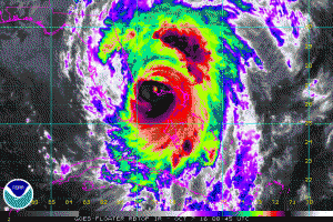
The Sunshine State’s east coast is bracing for impact of Major Hurricane Matthew, a Category 4 hurricane that battered the Bahamas on Thursday.
As of the 8pm advisory from the National Hurricane Center, the eye of Hurricane Matthew was located over the western end of Grand Bahama Island near latitude 26.6 North, longitude 78.9 West. The hurricane is moving toward the northwest near 13 mph and this general motion is expected to continue tonight with a turn toward the north-northwest early Friday. On the forecast track, the eye of Matthew should move away from Grand Bahama Island during the next few hours, and move close to or over the east coast of the Florida peninsula through Friday night.
Reports from a NOAA Hurricane Hunter aircraft indicate that maximum sustained winds are now near 130 mph with higher gusts. Matthew is a category 4 hurricane on the Saffir-Simpson Hurricane Wind Scale. Some fluctuations in intensity are likely while the hurricane moves toward the coast of Florida.
Hurricane-force winds extend outward up to 60 miles (95 km) from the center and tropical-storm-force winds extend outward up to 185 miles. Settlement Point in the Bahamas recently reported a sustained wind of 79 mph with a gust of 105 mph. The Lake Worth Pier near Palm Beach, Florida, recently reported a sustained wind of 46 mph and a wind gust of 60
mph.
The minimum central pressure estimated from NOAA Hurricane Hunter data is 939 mb (27.73 inches).