For the third time this hurricane season, a tropical cyclone is approaching Hawaii. Earlier this summer, Hurricane Hector passed to the south of Hawaii’s Big Island, producing blustery conditions and showers mainly on southern and eastern sides of Hawaii Island. In August, Hurricane Lane approached closer, bringing flooding rains to many islands over many days. In Hilo and surrounding communities, rainfall records were shattered; some locations picked up more than four feet of rain. And now natural disaster fatigued residents are at it again: authorities are urging that everyone state-wide wrap up their Hurricane Action Plans today and stock-up on whatever hurricane supplies they need by tomorrow.
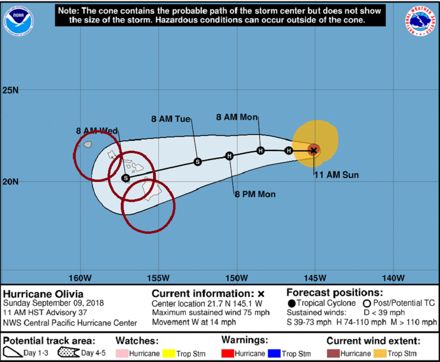
In the latest advisory issued by the Central Pacific Hurricane Center (CPHC) in Honolulu, Hawaii at 5pm ET / 11am HT, Hurricane Olivia’s center was located near latitude 21.7 North, longitude 145.1 West. Olivia is moving toward the west near 14 mph. The CPHC expects this west motion to continue for the next 24 hours or so with some slowing in forward speed. A west-southwest motion is then expected to begin Monday night or Tuesday. On the forecast track, Olivia will be approaching the main Hawaiian Islands later Tuesday and Tuesday night.
At this time, Olivia’s maximum sustained winds are near 75 mph with higher gusts. The CPHC expects little change in strength in the next 36 hours. Hurricane-force winds extend outward up to 30 miles from the center and tropical-storm-force winds extend outward up to 125 miles.
Impacts from a storm extend far beyond the center. Even islands where the center doesn’t pass near could experience gusty winds and flood-creating rains. Heavy rain, rockslides and landslides, road/bridge damage, and extended duration power outages are all concerns with this storm.
People in Hawaii, whether they are a resident or visitor, should make sure they have their Hurricane Action Plan in order. Authorities recommend that people have at least 2 weeks worth of water, non-perishable food, and medicine for themselves and their pets.
