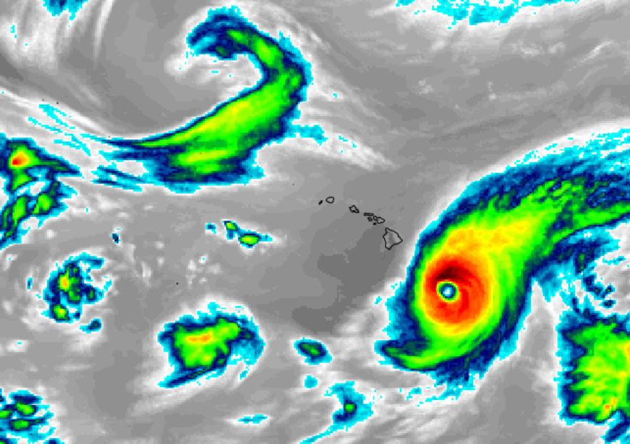
[Updated 12pm HT / 6pm ET] Two tropical cyclones could approach Hawaii in early August, including one that may reach the Big Island of Hawaii as a hurricane. Meteorologists at both the Central Pacific Hurricane Center in Honolulu, Hawaii and the National Weather Service in Miami, Florida are monitoring two areas of concern in the eastern Pacific. In the latest outlooks from the hurricane center, these two areas are the only areas of concern anywhere around American interests; the American hurricane basin remains quiet and no tropical cyclones are expected to form there over the next 5 days.
Tropical Depression #6e has formed this morning but was subsequently upgraded to Tropical Storm Erick. The National Hurricane Center in Miami began issuing advisories for Erick which is now forecast to become a hurricane by Tuesday morning. Once the storm passes 140 West longitude, the Central Pacific Hurricane Center will take over issuing advisories and forecasts for it.
The latest American GFS forecast model suggest some significant tropical weather concerns for Hawaii in the extended range. Definitely something to watch! As we mentioned yesterday, the Aloha State may be next to see a tropical cyclone in the U.S. this season.#HIwx pic.twitter.com/qRuWGA2mgF
— the Weatherboy (@theWeatherboy) July 27, 2019
Extended forecast guidance from the American GFS computer forecast model suggests Erick will continue to move closer to Hawaii over time, possibly bringing windy and showery conditions to parts of the state in the first days of August, around August 2-4. Right now, the GFS suggests the storm will weaken as it approaches Hawaii, with the center of circulation missing the islands. However, it is important to point out that large track and intensity errors are likely this far out and significant changes to the forecast are possible over time.
The next area of concern may be the greater threat of the two; and ironically, that system may share the name of another tropical cyclone that hit Hawaii in 2007.
According to the National Hurricane Center, an area of low pressure accompanied by disturbed weather is located a few hundred miles south-southwest of the Gulf of Tehuantepec. Gradual development of this system is expected, and a tropical depression is likely to form early next week while the system moves generally westward at 15 to 20 mph. While the NHC says the odds of tropical cyclone formation are low over the next 48 hours, pegging odds at only 30%, they said formation is likely over the next 5 days, boosting odds to a high 80%. Should that system become a named one after Erick, it would be called Flossie.
As in the Atlantic basin, Pacific storm names are recycled if they don’t result in a significant loss of life or property.
In 2007, Hurricane Flossie built itself up into a powerful Category 4 hurricane as it traveled through the central Pacific Ocean in mid-August. By August 13, it had weakened to a Category 3 storm, and as of the morning of August 14, the hurricane was predicted to pass within 100 miles of the Hawaiian Islands, bringing strong winds and heavy rain, particularly to the southern end of the Big Island. A hurricane watch, tropical storm warning, and flash flood watch were issued for the islands, and schools on the Big Island were all closed for the day as a precaution. In the end, wind-swept rains of less than 6″ impacted the island, as that storm weakened rapidly upon approach to the Aloha State.
Now nearly 12 years later, the American GFS forecast model is suggesting a more serious threat, with a possible landfalling hurricane on Hawaii’s Big Island around August 7. Unlike likely storm Erick before it, conditions are forecast to be more favorable for the intensification and survival of Flossie as it nears Hawaii over time. As is the case with the earlier storm, it is important to point out that large track and intensity errors are likely this far out and significant changes to the forecast are possible over time.
The next 2 systems to be named in the Pacific would be called Erick and Flossie. The name Flossie isn’t a stranger to Hawaii; in 2007, a storm with the same name brought heavy rain to Hawaii as a tropical storm. Here’s an image of it before it approached the Aloha State:#HIwx pic.twitter.com/FCBWBw2ikr
— the Weatherboy (@theWeatherboy) July 27, 2019