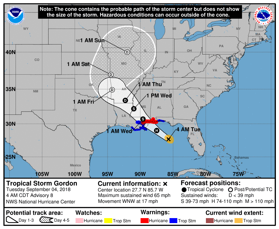
The National Hurricane Center is warning people along the central Gulf coast to prepare for the landfall of Hurricane Gordon later today. Gordon is a high-end tropical storm in the latest advisory from the National Hurricane Center (NHC), but is forecast to intensify today to a Category 1 hurricane on the Saffir-Simpson hurricane wind scale. Hurricane Warnings, Tropical Storm Warnings, and Storm Surge Warnings are up today ahead of the storm’s arrival.
As of the 6am ET / 5am CT update from the NHC, Gordon was located at 27.7N 85.7W which is about 230 miles east southeast of the mouth of the Mississippi River. Maximum sustained winds were at 65mph. The storm is moving to the west northwest at 17mph. Minimum central pressure is at 1004MB or 29.65″.
A variety of watches and warnings are in effect due to Gordon’s expected impacts.
A Storm Surge Warning is in effect for Shell Beach to Dauphin Island. A Storm Surge Warning means there is a danger of life-threatening inundation, from rising water moving inland from the coastline, in the indicated locations. The NHC warns, “this is a life-threatening situation. Persons located within these areas should take all necessary actions to protect life and property from rising water and the potential for other dangerous conditions. Promptly follow evacuation and other instructions from local officials.”
A Storm Surge Watch is in effect for west of Shell Beach to the Mouth of the Mississippi River and east of Dauphin Island to Navarre. A Storm Surge Watch means there is a possibility of life-threatening inundation, from rising water moving inland from the coastline, in the indicated locations.
A Hurricane Warning is in effect for the mouth of the Pearl River to the Alabama-Florida Border. A Hurricane Warning means that hurricane conditions are expected somewhere within the warning area. Preparations to protect life and property should be rushed to completion.
A Tropical Storm Warning is in effect for west of the Mouth of the Pearl River to east of Morgan City, Louisiana, including Lake Pontchartrain and Lake Maurepas, and the Alabama-Florida Border to Okaloosa-Walton County Line. A Tropical Storm Warning means that tropical storm conditions are expected somewhere within the warning areas.
On the NHC forecast track, the center of Gordon will move across the eastern Gulf of Mexico today, and will approach the north-central Gulf Coast within the warning area late this afternoon or evening, and move inland over the lower Mississippi Valley tonight or early Wednesday. Strengthening is expected today, and Gordon is forecast to be a hurricane when it makes landfall along the north-central Gulf Coast. Rapid weakening is expected after Gordon moves inland. Gordon’s remnants could gradually make their way to the Ohio Valley and the Northeast, introducing a flood threat there in the coming days.