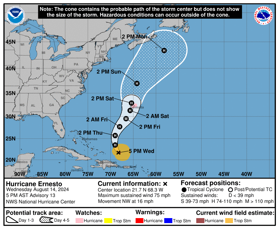
The National Hurricane Center is forecasting that Hurricane Ernesto will become a major hurricane by Friday morning, packing winds in excess of 110 mph. The Bermuda Weather Service, the equivalent of the National Weather Service for Bermuda, has also issued a Hurricane Watch for their entire island.
As of the latest advisory from the National Hurricane Center, Hurricane Ernesto, with winds of 75 mph, was about 180 miles east of Grand Turk Island and about 765 miles south-southwest of Bermuda. The minimum central pressure of the hurricane is down to 989 mb or 29.21″. It is moving to the northwest at 16 mph.
The only watch now in effect is a Hurricane Watch for Bermuda. A watch is typically issued 48 hours before the anticipated first occurrence of tropical-storm-force winds, conditions that make outside preparations difficult or dangerous.
The National Hurricane Center is forecasting the storm to pass over Bermuda this weekend. A turn toward the north-northwest and north is expected tonight and on Thursday. A northward to northeastward motion at a slower forward speed is expected Friday and Saturday. While maximum sustained winds are near 75 mph with higher gusts now, the National Hurricane Center says that strengthening is forecast during the next couple of days, and Ernesto could become a major hurricane by Friday. A hurricane becomes a “major hurricane” once its maximum sustained winds exceed 110 mph.
The current National Hurricane Center forecast brings Hurricane Ernesto directly over the island of Bermuda on Saturday, with tropical storm conditions expected to arrive by as early as Friday afternoon. Ernesto is expected to produce total rain accumulations
of 3-6″ on Bermuda with isolated maximum amounts of 9″. This rainfall may result in considerable life-threatening flash flooding.
Rainfall is expected to diminish this evening across Puerto Rico and the U.S. and British Virgin Islands. Total rainfall amounts from
Ernesto are expected to be in the 6-10″ range, with maximum amounts of a foot across southern to eastern Puerto Rico, 3-6″ across northwestern Puerto Rico, and 4-6″ inches across the U.S and British Virgin Islands.
Swells generated by Ernesto are affecting portions of the northern Leeward Islands, the Virgin Islands, Puerto Rico, the
Dominican Republic, and the Turks and Caicos Islands. These swells will reach the southeastern Bahamas tonight, and Bermuda and the rest of the Bahamas on Thursday. Swells are expected to reach the east coast of the United States Thursday night and continue into the
weekend. The National Hurricane Center warns, “These swells are likely to cause life-threatening surf and rip current conditions.” They add, “Beach goers should be aware of a significant risk of life-threatening surf and rip currents, and stay out of the water if advised by lifeguards. Surf and rip currents are also possible on the Virgin Islands, Puerto Rico, the Dominican Republic, the Turks and Caicos, and the Bahamas during the next few days.”