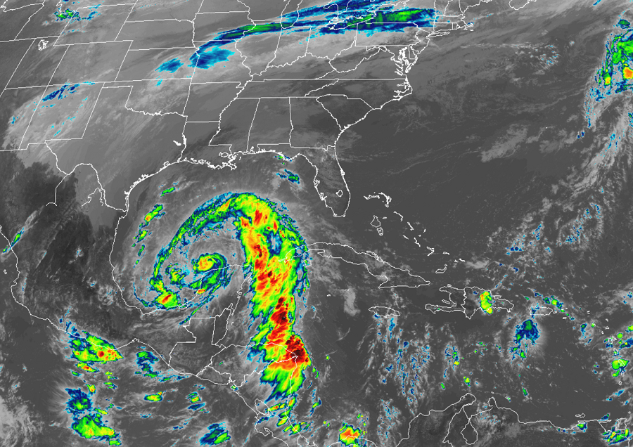
Hurricane Zeta struck Mexico’s Yucatan Peninsula last night, weakening it to a strong tropical storm; the National Hurricane Center (NHC) is forecasting it to quickly regain strength back to hurricane status and create all sorts of mayhem in the United States. A destructive and potentially lethal storm surge, flooding rains, and even early season snow are possible as the system tracks from the Gulf of Mexico up into the Mid Atlantic states. Rough surf, beach erosion, isolated tornadoes, and wind damage are additional hazards people will face with this storm.
Right now, Zeta is located about 485 miles south of the Mouth of the Mississippi River. The storm, with minimum central pressure of 986 mb or 29.09 inches, has maximum sustained winds of 65 mph. It is moving to the northwest at 14 mph.
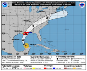
The NHC says Zeta should turn toward the north tonight, and a faster northward to north-northeastward motion is expected on Wednesday. On the forecast track, the center of Zeta will move over the southern Gulf of Mexico today and over the central Gulf of Mexico tonight. Zeta is forecast to approach the northern Gulf Coast on Wednesday, make landfall on the Gulf coast late Wednesday or Wednesday night, and move inland across the southeastern United States early Thursday.
Zeta is forecast to re-strengthen while it moves over the southern Gulf of Mexico, and become a hurricane again later today. According to the NHC, Zeta is forecast to be at or near hurricane strength when it reaches the northern Gulf Coast late Wednesday.
Based on the strength, size, and expected impacts of what will be Hurricane Zeta’s landfall, the National Hurricane Center has issued a variety of warnings and watches for the Gulf coast.
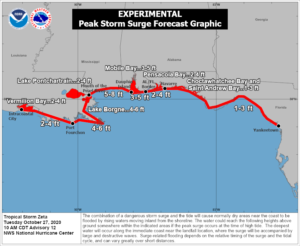
A Storm Surge Warning is in effect from Intracoastal City, Louisiana to Navarre, Florida and for Lake Borgne, Lake Pontchartrain, Vermilion Bay, Pensacola Bay, and Mobile Bay. A Storm Surge Warning means there is a danger of life-threatening inundation, from rising water moving inland from the coastline, during the next 36 hours in the indicated locations. “This is a life-threatening situation,” warns the National Hurricane Center. “Persons located within these areas should take all necessary actions to protect life and property from rising water and the potential for other dangerous conditions. Promptly follow evacuation and other instructions from local officials.”
A Hurricane Warning is in effect for Morgan City, Louisiana to the Mississippi/Alabama border; this includes Lake Pontchartrain, Lake Maurepas, and Metropolitan New Orleans. A Hurricane Warning means that hurricane conditions are expected somewhere within the warning area and is typically issued 36 hours before the anticipated first occurrence of tropical-storm-force winds, conditions that make outside preparations difficult or dangerous. The National Hurricane Center says preparations to protect life and property should be rushed to completion within this warning area.
A Tropical Storm Warning is in effect from the Mississippi/Alabama border to the Okaloosa/Walton County Line in Florida while a Tropical Storm Watch is in effect for the area west of Morgan City to Intracoastal City, Louisiana. A Tropical Storm Warning means that tropical storm conditions are expected somewhere within the warning area within 36 hours. A Tropical Storm Watch means that tropical storm conditions are possible within the watch area, generally within 48 hours.
As the storm slams into the northern Gulf Coast, the combination of a dangerous storm surge and the tide will cause normally dry areas near the coast to be flooded by rising waters moving inland from the shoreline. The water could reach as much as 5-8′ above ground level from the Mouth of the Pearl River to Dauphin Island, Alabama. A storm surge of a few feet is possible across a wide area of the Gulf Coast. The deepest water will occur along the immediate coast near and to the right of the landfall location, where the surge will be accompanied by large and dangerous waves. Surge-related flooding depends on the relative timing of the surge and the tidal cycle, and can vary greatly over short distances.
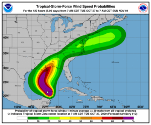
Hurricane force wind conditions are expected within the Hurricane Warning area on the northern Gulf Coast late Wednesday, with tropical storm conditions beginning Wednesday afternoon. Tropical storm conditions are expected within the Tropical Storm Warning area on the northern Gulf coast by late Wednesday, and tropical storm conditions are possible within the Tropical Storm Watch area late Wednesday. Damaging winds, especially in gusts, will spread well inland across portions of southeast Mississippi and southern Alabama Wednesday night.
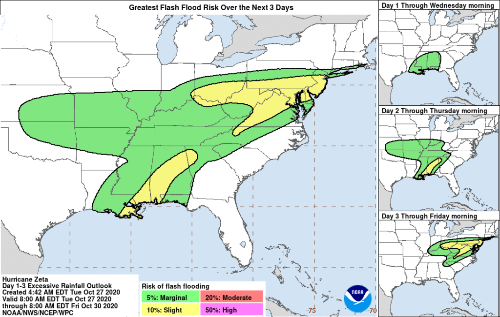
Zeta will create widespread, heavy, flooding rains. Rainfall totals of 4-8″ with local amounts of 12″ are possible through today across the Yucatan Peninsula of Mexico and the Cayman Islands. An additional 1-3″ inches of rain will be possible across western Cuba through Tuesday. An initial area of heavy rains will begin to impact the central Gulf Coast tonight, with the core of heavy rains spreading north into the
Ohio Valley and Mid-Atlantic through Thursday, near and in advance of Zeta. Rainfall totals of 2-4″ with isolated amounts of 6″ are expected across these areas, resulting in flash, urban, small stream, and minor river flooding.
A few tornadoes are possible Wednesday and Wednesday night over southeastern Mississippi, southern Alabama, and the western Panhandle of Florida.
As what’s left of Zeta moves north and east into the Mid Atlantic, it will transition to a powerful post-tropical storm with strong winds and heavy precipitation. As the center of the storm approaches New Jersey, some intensification is expected with tropical storm force winds possible across portions of southern New Jersey, Delaware, Maryland, and Virginia. The gusty winds will be joined by very heavy rain in this area, especially late Thursday into early Friday.
As the storm further intensifies as it moves north and east out to sea, it will help drag down cold air from the upper levels of the atmosphere over portions of the northeast. The American GFS and European ECMWF forecast models both indicate that this cold pool of air will be sufficient enough to turn rain into heavy wet snow across portions of the northeast.
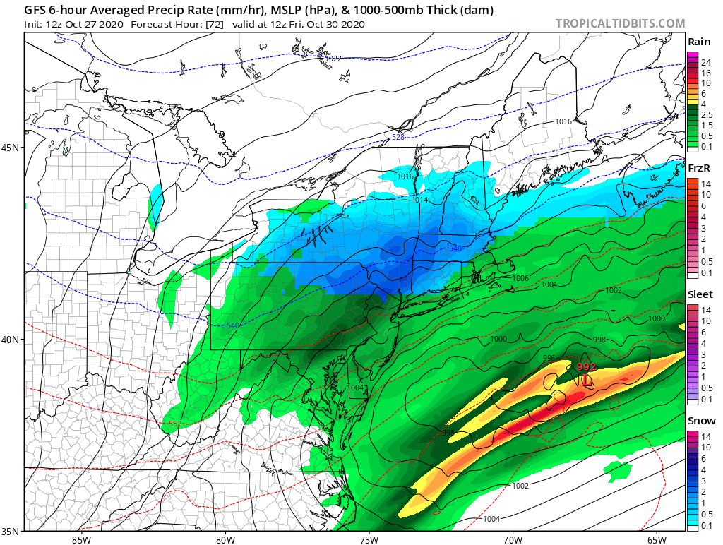
Right now, it appears snow could fall from New Jersey north into central New Hampshire and Vermont and southern Maine. It is possible the snow will fall with enough vigor to create accumulations, and some of those accumulations could be quite heavy over portions of New York, Vermont, Massachusetts. As more data is ingested into forecast models from this part of the country, a more accurate idea of who will get how much snow will be determined in the next 24 hours.
Zeta is forecast to completely leave the United States by later Friday, ending the chapter of another record hurricane for the exceptionally busy 2020 Atlantic Hurricane Season.