
Another storm system moving through the northeast will bring a round of accumulating ice and snow this weekend to a region that just some yesterday; the potential for an even larger snow storm is looming for the early to middle part of next week too.
As a surface low lifts north along a front in the Southern Plains, it
will cross the Ohio River Valley with over-running moisture from the Gulf of America to break out another round of rainfall across the Ohio Valley Saturday into Sunday. As the shield of rainfall reaches the upper Ohio Valley
later Saturday into early Sunday, it will cross colder grounds and present
the potential for additional freezing rain and sleet across Pennsylvania,
western and northern Maryland with 0.10-.25″ accumulations possible. Light accumulations of ice are also possible across Virginia, Delaware, New Jersey, and New York.

The surface low will meld with an upper-level wave moving through the area too, strengthening the low as it crosses south of Long Island quickly out to sea. As the storm evolves, there will be another swath of heavy snow late Saturday into Sunday with 4-6″ across southern New York into Connecticut. The Lake Ontario Lake Effect plume will increase snowfall totals along/downstream with near a foot or more of snow possible near the Lake and 6-12″ possible through Albany, New York east through Massachusetts.
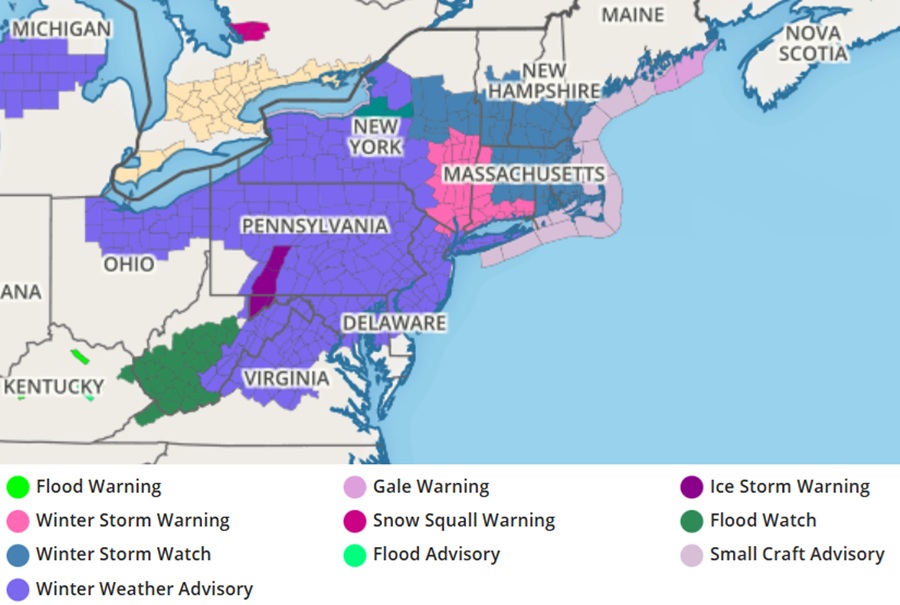
With snow and ice on the way, the National Weather Service has issued many Winter Weather Advisories and Winter Storm Warnings. Winter Storm Warnings are up for northern New Jersey, southeastern New York, western and southern Connecticut, and western Massachusetts. Generally Winter Weather Advisories are up south of there while Winter Storm Watches are up north and east from there.
Models continue to depict a threat of a more substantial snow event or two next week, with the first possible Tuesday into Wednesday and the other Wednesday into Thursday. How the weekend storm evolves, along with another atmospheric dynamics around the continent, will help set the stage for what comes beyond the weekend storm for next week. It remains too soon to say with certainty how next week’s storms will evolve.
