While many in the eastern United States continue to recover from the Blizzard of 2018 and the Arctic blast that followed it, it appears Old Man Winter will strike again as the threat of an ice storm looms.
After a brutally cold weekend, high pressure will slowly move off shore setting the stage for the next Eastern weather maker. A southwesterly flow will increase through the night Sunday in conjunction with a strengthening pressure gradient in between the retreating high and an upstream low pressure system over Ontario, Canada. On Monday and Monday Night, low pressure will pass south of James Bay
on Monday with an attendant cold front crossing the Great Lakes
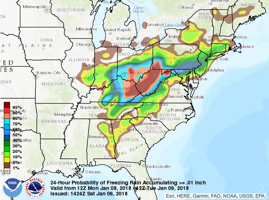
region. A southwesterly flow will continue in the pre-frontal warm sector, bringing the threat of precipitation from southwest to northeast over the southeast, Ohio River Valley, and eventually the Mid Atlantic. While precipitation amounts look to be light, it appears precipitation will fall in this region as sleet or freezing rain, leading to ice accumulation over a potentially large area.
There will be a snow / ice line setting itself up in the northeast with this weather system. It’s still too early to define where this line will set itself up Monday night, but right now, it appears the snow / mixed line will be along I-80 in Pennsylvania and New Jersey.
A potential worse-case scenario may unfold for the Monday evening commute in a heavily populated area of Pennsylvania and New Jersey. Given how cold the ground is, any untreated roads would become icy. The best chance for freezing rain is most evident between I-78 and the I-95 corridor; however, this threat area could shift as the storm takes shape on Monday.
By Tuesday, milder air will surge north, with precipitation ending from south to north, possibly as plain rain in southern locations. High pressure will return to the region, staying in place until the next winter storm threat arrives at the end of the week.
