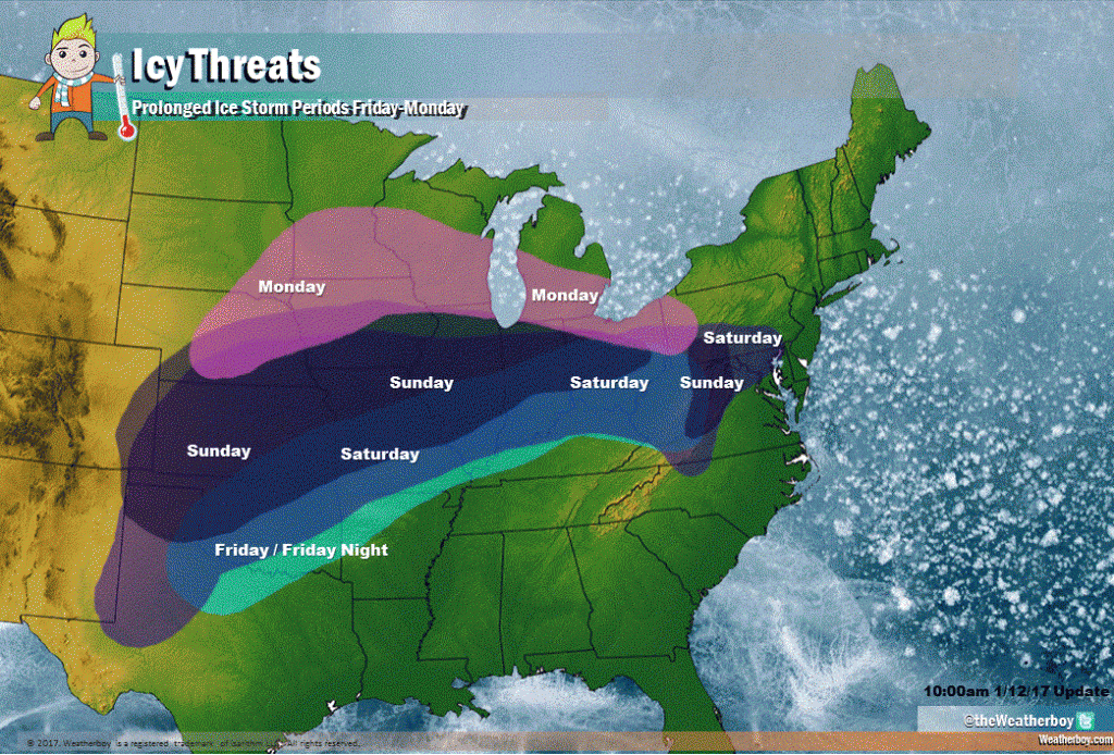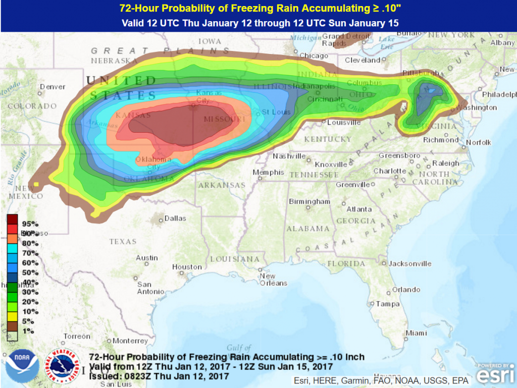
A major ice storm is about to unfold across an unusually wide swath of the country. The Plains will be the hardest hit by freezing rain and sleet (both terms will be referred to as ice) but smaller amounts of ice will also be found in the Ohio Valley as well as parts of the interior Northeast and mid-Atlantic.
The duration of this ice is also highly uncommon, with the onset of ice being expected Friday morning across the southern and central Plains while portions of the northern Plains and parts of interior Pennsylvania finally will bid this storm adieu on Monday. Some locales in the Plains could see 36 to as much as 48 consecutive hours of freezing rain.
The setup for this ice storm will be a potent upper-level disturbance over the Desert Southwest Friday that will slowly push to northeast over the Plains this weekend. At the same time that a generally mild southwest flow pattern is being set up in the upper levels of the atmosphere by this disturbance, a pair of arctic high pressure systems to the north will provide cold and dry arctic air at the lowest levels of the atmosphere. Without the arctic being supplied by these pair of high pressure systems and the southwest flow aloft caused by the upper-level disturbance, an ice storm of this magnitude and duration would not be possible.

Going day by day, Friday and Friday night the ice will be found from northern Texas northeastward into central and southern Indiana then will head east at night along the Ohio River to near Pittsburgh. Some of the metropolitan areas that will be hard hit will be Springfield, Mo., St. Louis, Springfield, IL (late in the day there) and Amarillo, TX. A half inch of ice or more can be expected from northern Texas northeastward into west-central Missouri this day alone. The threshold for ice accumulation to become a major threat for downed trees and tree limbs that cause power outages is only a quarter of an inch, so threat is there for major problems across this region.
On Saturday, the main ice zone shifts just a bit north as the areas of high pressure hold on strong as it continues to supply arctic air at the low levels of the atmosphere. The St. Louis region westward in eastern Kansas and northeast Oklahoma regions look to be particularly hard hit on this day. The ice zone will be found from northern and western Texas into northern and western Oklahoma northeastward into much of Kansas and eastward through much of Missouri and straight into Illinois and Indiana and then eastward along the Ohio River. Wichita, KS and Columbia, MO will also be two cities that will see the threat of major ice accumulations this day.
As the precipitation strings east along an arctic boundary, portions of the mid-Atlantic and Appalachian area may also see some light ice amounts. Philadelphia, Baltimore and Washington D.C. as well as smaller cities such as Altoona and Harrisburg in central Pennsylvania, York and Lititz in southern Pennsylvania, Morgantown in West Virginia could see a mix of snow, sleet and freezing rain. The Shenandoah Valley of Virginia and western and central Maryland could see travel impacted by some icing.
The ice zone continues its northward retreat on Sunday. From northwest Oklahoma and extreme northern Texas, into all of Kansas into eastern Nebraska eastward into north-central Illinois and central and northern Indiana will be the main ice zone. Kansas City, MO will be covered by quite a bit of ice Saturday night into Sunday, setting up an unique situation as the city hosts a NFL playoff game that afternoon. Other cities that are likely to see major impacts will be Lincoln, NE and Peoria, IL. Some lingering light freezing rain or freezing drizzle can be found in the Shenandoah Valley of Virginia.
By the start of the new workweek on Monday, the icing zone will be found in the northern Plains and into the Great Lakes. Chicago and Detroit could see a rare ice storm, though icing amounts should be nothing like what they will see in the Plains. There could be some light freezing rain as far east as central Pennsylvania on this day as well.
Ice storms are difficult to predict and some of the details may be off. That being said, the risk of a major ice storm is very high. The region that will almost certainly see life-threatening ice accumulations will be found from extreme northern Texas into northern and western Oklahoma northeastward into southern and eastern Kansas and then east through southern and central Missouri and into southern Illinois. Precautions should be made in this region for impassable roads, downed trees and power outages. Everyone in that area is at risk of seeing at least a quarter of an inch of ice with much of that zone seeing the potential for half of an inch.
Generally, hyperbole is avoided as much as possible but to say that this ice storm could be a once in a lifetime ice event for some in that prime region is not an exaggeration. The governor of Missouri has already declared a state of emergency and other state governments would be wise to follow his lead. Preparations and plans should be put into place now to avoid the risk of potential loss of life and property.