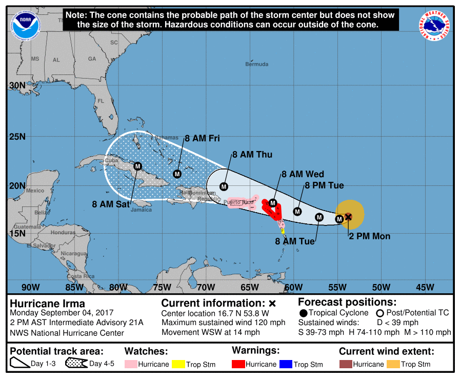
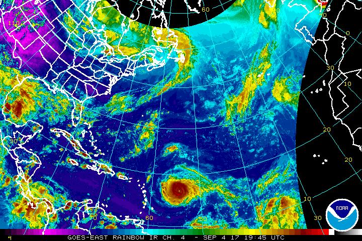
Hurricane Irma is now a Category 4 Major Hurricane with maximum sustained winds of 130mph, according to the National Hurricane Center (NHC.) The NHC expects Hurricane Irma to pick up additional size and strength and officially forecasts it to have maximum sustained winds of at least 150mph within the next 24 hours.
Various governments in the Caribbean have issued Hurricane Warnings and Watches and Tropical Storm Warnings and Watches. The government of Antigua has issued a Hurricane Warning for the islands of Antigua, Barbuda, Anguilla, Montserrat, St. Kitts, and Nevis. The National Weather Service has issued Hurricane Watches for Puerto Rico and the US Virgin Islands. Hurricane Watches are now also up for the British Virgin Islands. The government of Barbados has issued a Tropical Storm Watch for Dominica. Yesterday, the the government of the Netherlands issued a Hurricane Watch for the islands of Saba, St. Eustatius, and Sint Maarten.; the government of France issued a Hurricane Watch for St. Martin and Saint Barthelemy and a Tropical Stom Watch for Guadeloupe. A Hurricane Warning means that hurricane conditions are expected somewhere within the warning area. A warning is typically issued 36 hours before the anticipated first occurrence of tropical-storm-force winds, conditions that make outside preparations difficult or dangerous. In Hurricane Warning areas, preparations to protect life and property should be rushed to completion. A Hurricane Watch means that hurricane conditions are possible within the watch area. A watch is typically issued 48 hours before the anticipated first occurrence of tropical-storm-force winds, conditions that make outside preparations difficult or dangerous. A Tropical Storm Watch means that tropical storm conditions are possible within the watch area, generally within 48 hours.
The National Hurricane Center reports 4 key messages to share:
- Irma is expected to affect the northeastern Leeward Islands as a dangerous major hurricane, accompanied by life-threatening wind, storm surge, and rainfall impacts, along with rough surf and rip currents. Hurricane warnings have been issued for portions of the
Leeward Islands. Preparations should be rushed to completion, as tropical-storm force winds are expected to first arrive in the hurricane warning area by late Tuesday. - Irma could directly affect the British and U.S. Virgin Islands and Puerto Rico as a dangerous major hurricane later this week. Hurricane watches have been issued for these areas, and tropical- storm-force winds could arrive in these areas by early Wednesday.
- Irma could directly affect Hispaniola, the Turks and Caicos, the Bahamas, and Cuba as a dangerous major hurricane later this week. Residents in these areas should monitor the progress of Irma and listen to advice given by officials.
- There is an increasing chance of seeing some impacts from Irma in the Florida Peninsula and the Florida Keys later this week and this weekend. In addition, rough surf and dangerous marine conditions will begin to affect the southeastern U.S. coast by later this week. Otherwise, it is still too early to determine what direct impacts Irma might have on the continental United States. However, everyone in hurricane-prone areas should ensure that they have their hurricane plan in place, as we are now near the peak of the season.
The National Hurricane Center’s official 5-day forecast brings the storm on or near Puerto Rico, the northern side of Haiti and the Dominican Republic, and central Cuba with time; it is not yet known if the center will pass through or to the south or north of these locations. By the weekend, Hurricane Irma will be approaching south Florida. From there, it is likely to interact with a trough moving through the United States. It is still too soon to know how Irma will interact with it; it could help it curve it up the US East Coast, or it can slip by it, allowing for a more direct impact on Florida, and perhaps an entry into the Gulf of Mexico, as a possibility.
The US Government is deploying additional meteorological assets in the area of the storm today; they are also launching extra weather balloon missions in the continental United States to better understand the current and future steering currents that will influence Hurricane Irma’s eventual path.
It is still too soon to know exactly where Hurricane Irma will go. It is likely to be a large and dangerous hurricane as it approaches the United States coast. While it’s more likely than not that Irma will strike the United States, it is not yet known exactly where it will do so and how strong it’ll be when it gets there. As a result, it is imperative that all US East Coast and Gulf Coast residents have a Hurricane Action Plan in place immediately. It may become necessary to act on it later this week ahead of Hurricane Irma’s arrival.
Experts believe this Atlantic Hurricane Season, which runs through to the end of November, will be a busy one. Dr. Phil Klotzbach and the experts at Colorado State University updated their seasonal outlook again on July 5, showing a much more active than normal season expected. The National Oceanic and Atmospheric Administration (NOAA) also released their own forecast which shows this hurricane season to be likely more active than others.
