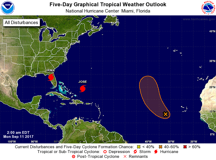
The peak of the Atlantic Hurricane Season is typically on September 10, and this year appears to be climatologically on-time as meteorologists track Irma’s impact, explore a potential US East Coast threat from Jose, and watch as Lee takes shape over the open waters of the central Atlantic.
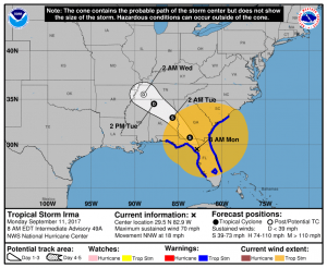
Hurricane Irma, which struck and destroyed Cudjoe Key in the Florida Keys on Sunday at 9:10am as a Category 4 hurricane, has made its way up through the Florida Peninsula. The storm made a secondary landfall onto Marco Island as a Category 3 hurricane, and inched its way up north generally up I-75 through Naples and into northern Florida where it sits this morning in a weakened tropical storm form.
“Apocalyptic scene over Keys, especially Big Pine & Bahia Honda Keys. Literally dug ourselves out, made path for others to follow,” says storm chaser Simon Brewer on Twitter who was in the eyewall for the initial landfall. Brewer also reports that he witnessed a “large, stovepipe shaped tornado near Sugarloaf Key on inside edge of Hurricane Irma’s eyewall.”
A huge airborne relief mission is en route to the Keys to help people impacted by the devastation caused when the eye of Hurricane Irma blasted through the Lower Florida Keys at daybreak Sunday morning. Monroe County Emergency Management Director Martin Senterfitt called the destruction caused by Irma a “humanitarian crisis.” During a conference call, Senterfitt said that “disaster mortuary teams” are needed for the dead there.
Florida Director of Emergency Management Bryan Koon said he could not confirm or deny reports of multiple deaths or extensive damage admitting, “I don’t have any numbers on fatalities at this point.” But he did estimate that 10,000 people stayed behind in the Florida Keys despite dire warnings for people to get out.

In the 8am advisory from the National Hurricane Center, Irma was officially downgraded to Tropical Storm Status with maximum sustained winds of 70mph. In the advisory, the center of circulation was 105 miles north-north-west of Tampa, but its impacts were being felt over most of Florida and a large portion of the southeastern United States.
While far weaker than it was yesterday, Irma is still packing a punch over a huge area. In addition to bringing tropical storm force winds throughout Florida from Lake Okeechobee north, tropical storm force winds extend throughout much of Georgia and South Carolina along with parts of southeastern Alabama. The wind field is so large that the National Weather Service posted Tropical Storm Warnings for Atlanta, Georgia –a first for the far inland city. While natural tropical foliage such as palm trees do a better job of dancing about in storm winds in Florida, some deciduous hard woods over portions further inland in the southeast, such as Georgia, cannot handle the stresses of strong storm winds. As such, trees and their limbs are likely to tumble, bringing down wires and communication networks with them.

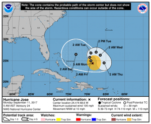
While recovery efforts continue with Irma’s path of destruction throughout the Caribbean and southeast US, there’s some concern with Hurricane Jose in the western Atlantic. At 5am, Jose was located 255 miles northeast of Grand Turk Island. With maximum sustained winds of 105mph , Hurricane Jose has a low central pressure of 968mb.
Global forecast models, such as the American GFS and European ECMWF model, have suggested that with time, Jose could threaten the Mid Atlantic, Northeast, or perhaps even Canadian east coast. Such a landfall would happen no earlier than next weekend or next week; due to lack of reliability and dependability of the global forecast models on their ability to track tropical cyclones in the extended range, not much weight is being put on them and their forecasts for Jose yet. But with the peak of the hurricane center here and the east coast of North America always vulnerable to possible hurricane and tropical storm impacts in season, it is something that will be continued to be watched. For now, the National Hurricane Center does inch it closer to the United States by Saturday, but is of no direct threat to land at that time.
Swells from Tropical Storm Irma’s wind field as well as Hurricane Jose will continue to whip up waters along much of the US east and Gulf coasts this week. Even with the storms far away, dangerous tides and rip currents could be a problem even on sunny beaches well away from the storm.
While meteorologists will track Jose over time, the National Hurricane Center is also monitoring an area of disturbed weather that could become a tropical cyclone over time. Should the system develop into a tropical cyclone and become a tropical storm, it would be named Lee, the next name to be used for the Atlantic Hurricane Season. However, unlike Irma and Jose, it is expected to curve out over the open waters of the Atlantic and dissolve over time, not threatening any landmass during its life cycle.
Experts believe this Atlantic Hurricane Season, which runs through to the end of November, will be a busy one. Dr. Phil Klotzbach and the experts at Colorado State University updated their seasonal outlook again on July 5, showing a much more active than normal season expected. The National Oceanic and Atmospheric Administration (NOAA) also released their own forecast which shows this hurricane season to be likely more active than others.