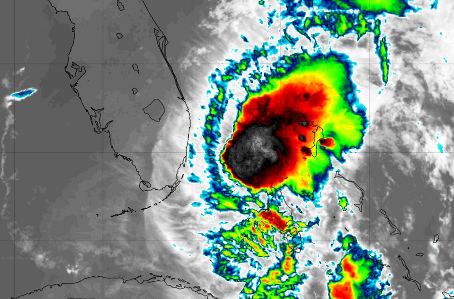
The National Hurricane Center in Miami, Florida wants people up and down the entire U.S. East Coast to prepare for impacts from Isaias. In today’s 5am update, they say the center of Tropical Storm Isaias is roughly 45 miles east north east of Fort Lauderdale, Florida and 45 miles southeast of West Palm Beach, Florida; with maximum sustained winds of 65 mph, Isaias is heading northwest at 9 mph.
To prepare residents for impacts from this storm, the National Hurricane Center has extended Tropical Storm Warnings north along the southeast United States coast to South Santee River in South Carolina. The Hurricane Warning that was up along the east coast of Florida has been replaced with a Tropical Storm Warning. Tropical Storm Warnings remain in effect for Lake Okeechobee too. A Storm Surge Watch is now in effect for Edisto Beach, South Carolina north to Cape Fear, North Carolina; it is also in effect for Jupiter Inlet to Ponte Vedra Beach, Florida. A new Tropical Storm Watch has been extended northward to Surf City, North Carolina. A Hurricane Warning remains in effect for Bimini, the Berry Islands, and Grand Bahama Island.
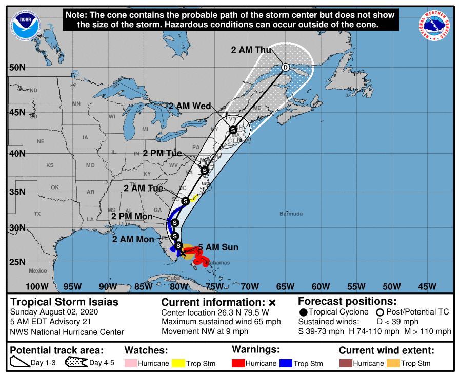
Additional Tropical Storm Watches or Warnings will likely be needed for Virginia, Maryland, Delaware, New Jersey, and New York later today or early tomorrow ahead of the expected impacts from this storm.
Each watch and warning means something different. A Storm Surge Watch means there is a possibility of life-threatening inundation, from rising water moving inland from the coastline, in the indicated locations during the next 48 hours. A Tropical Storm Warning means that tropical storm conditions are expected somewhere within the warning area, generally within 36 hours. A Tropical Storm Watch means that tropical storm conditions are possible within the watch area, generally within 48 hours.

While Isaias is moving to the northwest today, the National Hurricane Center expects it to begin to take a north-northwestward motion by tonight. A turn toward the north and north-northeast is anticipated on Monday and Tuesday with an increase in forward speed. On the forecast track, the center of Isaias will move near or over the east coast of Florida today through late tonight. On Monday and Tuesday, the center of Isaias will move from offshore of the coast of Georgia into the southern mid-Atlantic states. It appears the worst impacts from this storm will be in South Carolina, eastern North Carolina, eastern Virginia, eastern Maryland, all of Delaware, all of New Jersey, eastern Pennsylvania, eastern New York including the New York City metro area and Long Island, and much of New England.
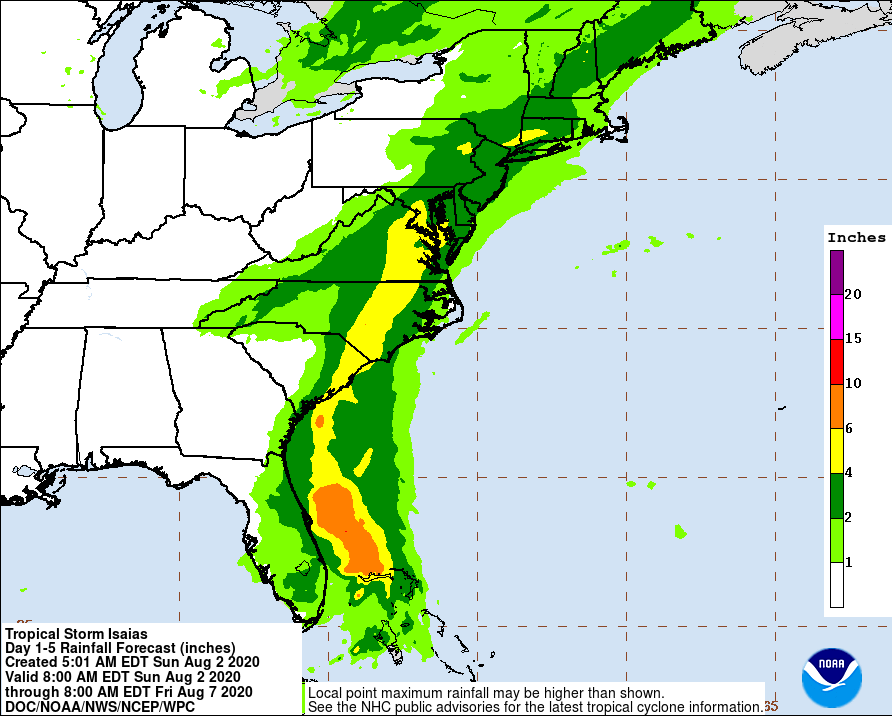
These are the expected impacts and timing based on this morning’s new data:
- Florida
- Occasional strong tropical storm conditions along the east coast with threat of storm surge flooding and heavy rains. Isolated tornadoes and waterspouts.
- This afternoon / evening.
- Georgia
- Some heavy showers and squalls at the immediate coast; some tropical storm conditions possible. Of the East Coast, Georgia should be impacted the least.
- Monday Morning
- South Carolina
- Weak hurricane or strong tropical storm conditions likely; extremely heavy rains, very strong winds, even away from the coast. Storm surge flooding likely along portions of the coast. Isolated tornadoes possible. Waterspouts possible on the Atlantic coast.
- Most of Monday
- North Carolina
- Weak hurricane or strong tropical storm conditions across the eastern half of the state. Heavy rains, strong winds, and coastal storm surge flooding possible. Some tornadoes possible in the coastal plain; waterspouts in coastal areas.
- Monday PM into Monday Night
- Virginia
- Strong tropical storm conditions expected; torrential, heavy rain, gusty winds. Some coastal flooding and beach erosion. Risk of an isolated tornado or two.
- Late Monday Night / Early Tuesday
- Maryland
- Tropical storm conditions expected over the eastern half of the state; rain likely state-wide. Flooding downpours likely. Gusty winds. Coastal flooding and beach erosion. Risk of an isolated tornado or two. Waterspouts possible at the coast.
- Early Tuesday
- Delaware
- Tropical storm conditions expected state-wide with serious flooding issues possible. Gusty winds. Coastal flooding and beach erosion. Risk of an isolated tornado or two. Waterspouts possible at the shore.
- Tuesday Morning
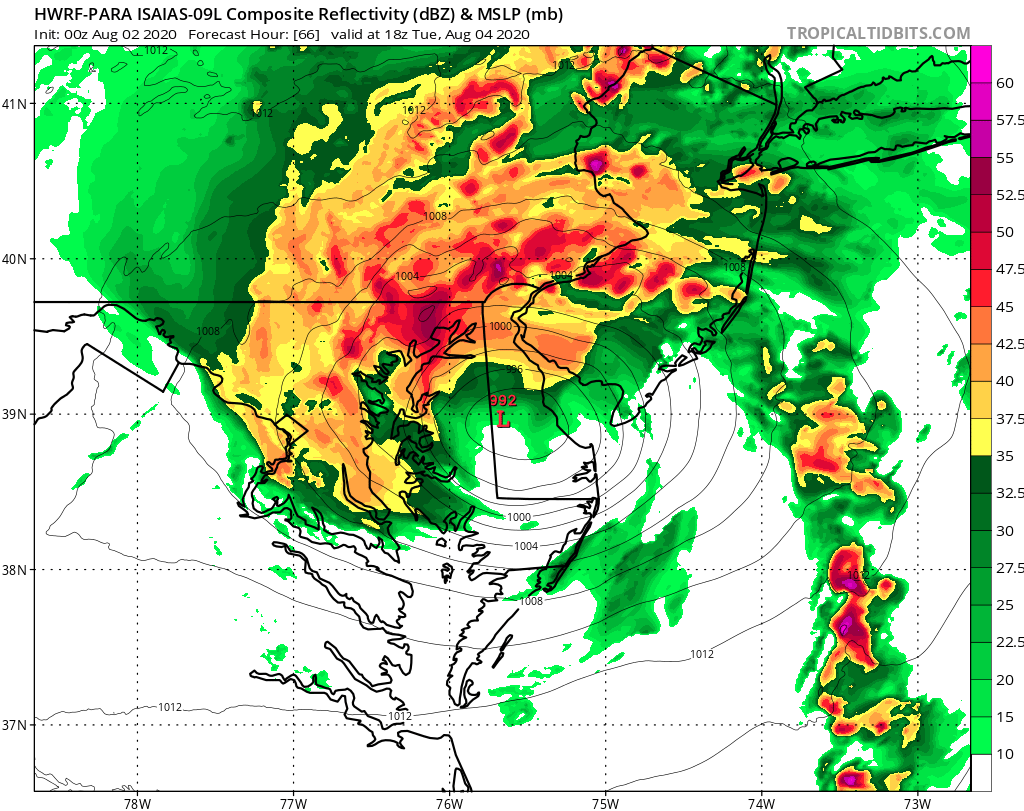
- New Jersey
- Tropical storm conditions expected statewide. Significant fresh water flooding likely; storm surge flooding possible along with damaging wind gusts and beach erosion at the coast. Some tornadoes possible. Waterspouts possible at the shore.
- Tuesday
- Pennsylvania
- Tropical storm conditions likely in the southeastern and eastern portions of the state; rain expected into central and west-central portions of the state. Significant fresh water flooding likely in eastern portions of the state. Risk of an isolated tornado or two.
- Tuesday
- New York
- Tropical storm conditions likely in the southeastern part of the state, including all of New York City and Long Island. Urban flooding possible. Heavy rain and gusty winds throughout the eastern half of the state; flash flooding possible. Damaging wind gusts and beach erosion at the coast; risk of storm surge flooding around New York City and the south shore of Long Island. Risk of isolated tornadoes and waterspouts.
- Tuesday
- Connecticut
- Tropical storm conditions possible at the coast; wind-swept rains elsewhere. Flooding conditions possible. Some storm surge possible along Long Island Sound.
- Tuesday
- Rhode Island
- Gusty winds and squalls likely. Slight risk of fresh water and storm surge flooding. Most rain should fall west of the state. Isolated tornadoes or waterspouts possible.
- Late Tuesday
- Massachusetts
- Tropical storm conditions possible. Otherwise, gusty winds, flooding rains expected, especially over western portions of the state. Slight risk of storm surge flooding and beach erosion. Most strong/severe weather should be over interior portions of the state versus the coast.
- Tuesday Afternoon
- New Hampshire
- Heavy rains, gusty winds expected over much of the state. Slight chance of coastal flooding; larger change of inland freshwater flooding.
- Tuesday Night / Wednesday Morning
- Vermont
- Heavy rains, gusty winds; inland freshwater flooding possible, especially over the southern half of the state.
- Tuesday Afternoon / Early Wednesday
- Maine
- Heavy rains, gusty winds, rough surf expected over coastal Maine. Squalls. Flooding possible over inland areas from heavy downpours.
- Early Wednesday
Tropical cyclones, including Hurricane Isaias, could have erratic behavior with fluctuating intensity and shifts in trajectory. Conditions could quickly change, prompting new watches or warnings as the storm moves along the coast. Despite today’s forecast track, it is important that everyone from Florida to Maine closely monitor the storm, prepare for its impacts, and take efforts to protect life and property until the threat has completely passed.
While Isaias probably won’t be a strong hurricane when it pushes into the Mid Atlantic and New England states, it will likely be a destructive tropical storm similar to past damaging tropical storms that have impact the region.

One such storm was Floyd in 1999. While Floyd initially made landfall as a hurricane into the North Carolina coast, it weakened to tropical storm status by late on September 16. The storm gradually lost its tropical characteristics as it quickly moved through the Delmarva Peninsula, eastern New Jersey, Long Island, and New England. Late on September 17, Floyd transitioned into an extratropical cyclone near the coast of southern Maine. Even though Floyd was “only” a tropical storm, it left a trail of death and destruction from North Carolina to Maine. In Virginia, Floyd created $101 million in damages and claimed 4 lives. In Washington, DC, damaging winds knocked down trees and power-lines; a wind gust of 56 mph was recorded at the Children’s National Medical Hospital. Maryland and Delaware were hit by flooding rains that caused more than $100 million in damages. In Delaware alone, 171 homes were damaged with 33 destroyed. New Jersey then saw its worst natural disaster in the state’s history at the time; 7 people were killed while major floods washed away homes and entire communities. More than 1,500 homes were damaged and 284 were destroyed in the Garden State, leaving more than 1,000 people homeless, with Middlesex, Somerset, and Bergen Counties among the worst hit. Even away from the coast, Pennsylvania was not spared; there, Floyd killed 13 people, largely due to drownings, fallen trees, or heart attacks, and another 40 people were severely injured. The hurricane left about $60 million in damage, mostly related to its heavy rainfall. Floyd continued adding to its damage and death toll as it moved into New York state, with many left without power for a prolonged period of time.
Another storm to impact the region was Tropical Storm Irene. After making landfall on North Carolina as a category 1 hurricane, it moved north, making a second landfall at Brigantine, New Jersey on August 28, 2011. Making landfall with winds of 70 mph, Irene moved over water again, hugging the New Jersey coastline. Later that morning, Tropical Storm Irene made landfall again with 65 mph winds in the Coney Island neighborhood of Brooklyn, New York. The storm would replace Floyd as New Jersey’s costliest natural disaster. It also created incredible damage and claimed lives into New England, leaving 48 people dead and creating a damage total of $13.5 billion.
Another notable non-hurricane storm to impact the U.S. East Coast was Sandy in 2012. In October of that year, Sandy moved ashore in Brigantine, New Jersey as an extratropical cyclone. Sandy killed 37 and causing nearly $30 billion in damages, surpassing Floyd and Irene as the Garden State’s biggest natural disaster. Widespread devastation occurred, particularly on Long Beach Island and the Barnegat Peninsula, where the Seaside Heights boardwalk collapsed into the ocean. Further north, storm surge flooding caused massive destruction along the Raritan Bay and traps thousands in Hoboken. All of New Jersey Transit’s commuter rail operations are affected, with some lines out of service for over a month. Sandy also causes the worst power outage in state history, blacking out over 2 million households. Sandy created equal devastation around New York City and across western Long Island, where coastal communities were inundated by a significant storm surge.
