Jose has weakened to a tropical storm, but is forecast by the National Hurricane Center (NHC) to become a hurricane again and potentially threaten the US East Coast; meanwhile, the NHC is also tracking two other tropical cyclone threats in the Atlantic. September 10 is the typical peak of the Atlantic Hurricane Season; however, the weeks after the peak tend to be more active than the weeks leading up to it and it appears the 2017 season will be no exception.
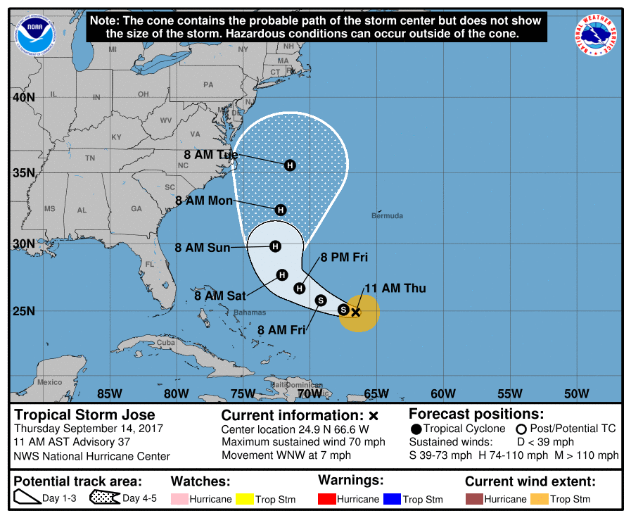
The environment Jose is in right now is unfavorable but that is expected to change over time with the NHC officially forecasting Jose to regain hurricane status. Satellite images show that Jose remains a sheared tropical cyclone. The center of the cyclone is on the northwestern edge of the deep convection, with any significant banding features located primarily in the southeastern quadrant. Using fixes from early-morning microwave data, the NHC says Jose appears to be moving west-northwestward at about 6 kt due to a building mid-level ridge to the north of the cyclone. Jose should gradually turn northwestward by the weekend and northward early next week while it moves around the ridge. A trough currently over the Lower Mississippi Valley into the northwestern Gulf of Mexico is expected to play a key role in how close Jose comes to the eastern United States. Some of the model solutions show the trough tugging on the tropical cyclone, causing a more north-northwestward motion at the end of the five day forecast period, while others have the trough deflecting the cyclone more out to sea. While it is too early for details at this point, the model guidance is generally west of the previous forecast and so the new NHC prediction is shifted to the left, about 60 nautical miles west-southwest of previous forecast at day 5.
According to the National Hurricane Center, vertical shear is forecast to lessen in about a day near Jose, so restrengthening is expected to commence on Friday since the cyclone is over warm water. After day 3, Jose will be interacting with the aforementioned Lower Mississippi Valley trough, which will probably cause an increase in shear, although some baroclinic energy could lessen those effects. Although the official intensity forecast shows little change at the end of the period, the model guidance does show Jose becoming larger and more spread out as it interacts with the trough.
Jose is producing a large swell field that will affect much of the southwestern Atlantic basin during the next few days, causing rough surf and rip current conditions. Even if Jose doesn’t impact the US or Canadian east coast directly, rough surf and rip currents as a result of the storm will indirectly impact much of the US East Coast, making beaches from Florida to Maine and points north dangerous in the coming days.
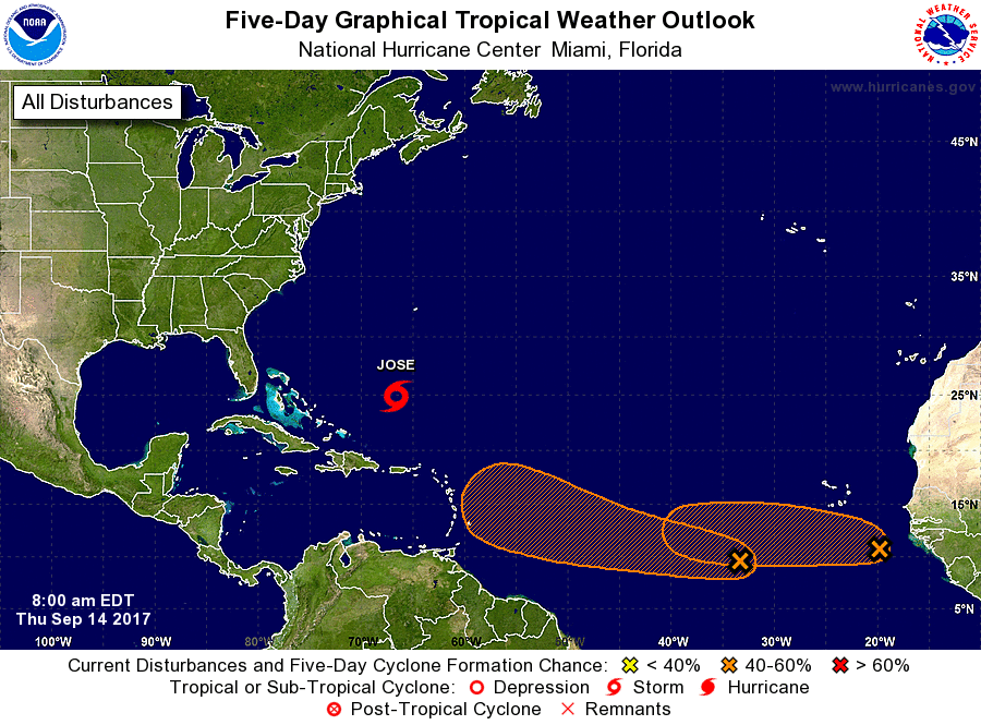
While Jose is the immediate concern, the National Hurricane Center is also monitoring two other areas of concern in the Atlantic. Both are located far away from land in the central and eastern Atlantic.
The first tropical wave is located about 800 miles southwest of the Cabo Verde Islands. This system continues to produce widespread showers and thunderstorms. Environmental conditions are expected to be conducive for gradual development of this system, and a tropical depression could form early next week while it moves westward at around 15 mph across the tropical Atlantic. While the NHC believes there’s only a 20% chance of tropical cyclone formation in the next 48 hours, odds jump to 60% over the next five days.
The second tropical wave is located between the west coast of Africa and the Cabo Verde Islands, is producing a large area of disorganized shower and thunderstorm activity. Some development of this system is possible over the next few days before upper-level winds become less favorable. The system is forecast to move westward at 10 to 15 mph across the far eastern tropical Atlantic for the next several days. The NHC thinks of the two disturbances, this second one is less likely to grow into a tropical cyclone. In the latest Tropical Outlook, the National Hurricane Center believes there’s only a 30% chance of formation in the next 48 hours and only 40% chance over the next five days.
While Jose may or may not impact the East Coast next week, it is still important that residents of the East Coast have a Hurricane Action Plan. From Jose or future threats from the tropics, it may become necessary for some to act on those plans before the Atlantic Hurricane Season ends later in November.
Experts believe this Atlantic Hurricane Season, which runs through to the end of November, will be a busy one. Dr. Phil Klotzbach and the experts at Colorado State University updated their seasonal outlook again on July 5, showing a much more active than normal season expected. The National Oceanic and Atmospheric Administration (NOAA) also released their own forecast which shows this hurricane season to be likely more active than others.
