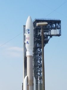
Excitement is building around the expected November 10, 2017 launch of the the Joint Polar Satellite System (JPSS) weather satellite. In the meteorological community’s eyes, the most important goal of the JPSS is to improve atmospheric data acquisition, especially in the polar regions. This enhanced data will then be fed into global forecast models thus leading to improved weather forecasts, especially in the 3-7 day time frame.
Recently, scientists involved in the mission participated in a REDDIT to shed some light on this new weather technology. During the REDDIT session which was open to the public, Dr. Mitch Goldberg, JPSS Chief Program Scientist, and Thomas Wrublewski, NOAA Physical Scientist, answered a wide variety of questions. Relevant to the expected improvements in the 3-7 day weather forecast, these two scientists described some instruments that will be on-board the JPSS and how they will help improve the atmospheric data.
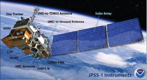
“JPSS-1 will have three critical instruments for weather forecasters that will aboard: VIIRS (Visible Infrared Imaging Radiometer Suite), CrIS (Cross-track Infrared Sounder) and ATMS(Advanced Technology Microwave Sounder). These instruments are considered essential to fulfilling ‘key performance parameters’ which means that without the data these instruments provide, NOAA’s National Weather Service can’t do its job in creating a weather forecast.” The tandem of Dr. Goldberg and Mr. Wrublewski continued, “VIIRS has more channels, higher resolution, and unique ‘day-night’ band that wasn’t available on earlier NOAA weather satellites. ATMS uses microwave radiation to ‘see’ Earth, so it can see into, through, and below clouds, which is a tremendous advantage over previous satellites. It also has an improved motor-scan system that should lead to a longer life in orbit.”

The two scientists concluded, “CrIS has over 2200 channels, each of which ‘sees’ a different part of the atmosphere. This is a huge increase, more than a hundred times more than we had before with previous infrared sounders. This means we have significantly increased our ability to see vertically (by a factor of 6), in detail, through the atmosphere. We can see details of the atmosphere in 1-2 kms. Previous infrared sounders provided data at 3-6 kms.”
Used in combination, these three instruments will give the NOAA and NWS team a better picture of the meteorological profile of the atmosphere, especially in the data-sparse polar regions. Because this satellite will travel over each pole 14 times each day, we can expect the data from the polar regions we feed into global forecast models, such as the American model called GFS and the European model called the ECMWF, to be vastly improved. And in the mid-latitudes of the northern hemisphere, where such places as the United States, southern Canada, France, Germany and Great Britain are located, this improved data will lead to more accurate weather forecasts, as much of their weather originates in the polar region, especially in the cooler months.
Like many other aspects of science, the better the data that is fed into a product, the more polished and accurate the information that comes out will be. That is the ultimate meteorological goal of the JPSS project, better data going into global forecast models will lead to a more accurate weather forecast coming out of them. Better weather forecasts save lives and property, something the NOAA, NWS and private meteorological organizations, as well as the public in general, all have as their ultimate goal and agree upon.