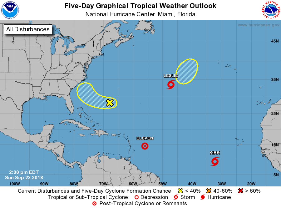
The Atlantic has perked up again, producing a new tropical depression, subtropical storm, and tropical storm this weekend. However, all but one is expected to make it beyond the weekend. Short-lived Tropical Depression #11, which formed east of the Windward Islands yesterday, dissipated this morning. Subtropical Storm Leslie also formed but is moving east over colder waters of the North Atlantic; it is expected to dissipate within days. Tropical Storm Kirk is expected to continue its movement to the west, perhaps threatening the Caribbean over time.

There’s a slight chance that a system not related to Hurricane Florence may impact the area hit by Hurricane Florence. A broad area of low pressure located between Bermuda and the Bahamas continues to produce limited shower and thunderstorm activity. The strong upper-level winds currently affecting the system are expected to diminish, and according to the National Hurricane Center, this could favor some development during the next couple of days. The low is forecast to move westward and
west-northwestward at about 10 mph over the southwestern Atlantic Ocean and by Tuesday or Wednesday, upper-level winds are forecast to strengthen again, likely limiting the development. By then, the system is expected to be moving by the southeastern coast of the United States. For not, the National Hurricane Center believes there’s only a 30% chance of tropical cyclone development here.
The final area being monitored in the Atlantic is near Subtropical Storm Leslie. According to the National Hurricane Center, a non-tropical low pressure system is expected to form north of Subtropical Storm Leslie along a central Atlantic cold front by Wednesday. Conditions appear conducive for this system to acquire subtropical or tropical characteristics by the latter part of this week. Until then, though, the National Hurricane Center says there’s no chance of development over the next 48 hours here.
The Atlantic Hurricane Season continues through to the end of November.