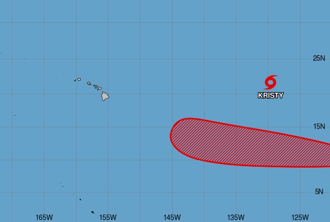
Kristy weakened from a hurricane to a tropical storm today, weakening as forecast by the National Hurricane Center (NHC.) But while Kristy is becoming less and less of a concern as it fizzles and heads west, a system to its south may develop into a new tropical cyclone and that new system may threaten Hawaii in early November.
Tropical Storm Kristy is forecast to weaken to a post-tropical depression by tomorrow evening, dissipating in the open waters of the Eastern Pacific half way between Mexico and Hawaii.
However, the Central Pacific Hurricane Center (CPHC) is tracking a new disturbance that they believe will become a tropical cyclone. Located about 2,500 miles east-southeast of Hilo, Hawaii now, there is an area of low pressure which is forming within a large area of disorganized showers and thunderstorms. According to the CPHC, environmental conditions appear conducive for additional development of this system, and a tropical depression is likely to form by the early to middle part of the upcoming week while moving westward or west-northwestward at about 15 mph over the far western portion of the eastern Pacific basin. The CPHC is fairly confident that formation will occur, saying there’s a high 80% chance of the system developing into a tropical cyclone over the next 7 days.
Like Kristy was, this system is between Mexico and Hawaii in open waters of the Eastern Pacific and is of no immediate threat to any land mass. The CPHC expects this system to move into the central Pacific basin on Wednesday or Thursday.
Global computer forecast models like the European ECMWF and the American GFS suggest that this new system, unlike Kristy, will be moving west towards the general direction of Hawaii over warmer waters which makes it more likely to retain tropical cyclone characteristics as it travels west. Because the system is expected to be much more south than Kristy ever was, it has higher odds of becoming an eventual threat to Hawaii.
What kind of threat, if any, this new system becomes to Hawaii is far too soon to say. The global forecast models suggest the system will be close to the Big Island of Hawaii around November 4 or 5. At the least, it should mean an increase of clouds and the threat of rain to at least the island of Hawaii. It could also be more significant than that, but it is too soon to say what that could be.
Emergency Management officials on Hawaii always caution people to have at least 14 days of supplies on-hand should a tropical cyclone threaten the state. “Stock your emergency preparedness kit with enough food and water for at least 14 days. Other essential items include, a battery-operated radio to receive emergency communications and essential medication,” the Hawaii Emergency Management or HI-EMA, recommends. “HI-EMA recommends you store your emergency supplies in a sturdy kit such as a rolling cooler. An added bonus to using a sturdy container is that it can be used as a seat if you need to evacuate to a shelter. Water is essential to sustaining life and is an important part of your emergency preparedness kit. General guidance is for people to store one gallon of water per person, per day for at least 14 days. This can be done by storing cases of water in a cool, dry place or by storing your own tap water. ” Those with health concerns are also urged to stock-up too: “If you have a condition requiring medication, make sure to stock extra with your emergency supplies. A hard copy of any prescriptions may also help if you need to resupply after a disaster. If your medication requires refrigeration, consider purchasing a generator or storing a supply of ice packs and a cooler for use if power goes out.”
The Central Pacific Hurricane Season runs through to the end of November, just like the Atlantic Hurricane Season.