• Skip to primary navigation
  • Skip to main content
  • Skip to primary sidebar

Weatherboy

Weatherboy Weather News, Maps, RADAR, Satellite, and Forecasts.

  • Local
  • Earth Science News
  • RADAR
  • Current Warnings
  • Satellite
  • Current Maps
  • Forecast Maps
  • Video

Last of Florence to Impact Mid Atlantic, Northeast Today

by Weatherboy Team Meteorologist - September 18, 2018

The Excessive Rain Outlook highlights an area in yellow with the best chances of seeing heavy rain and potential flood issues today through 8am tomorrow. Image: NWS

What’s left of Hurricane Florence will soak portions of the Mid Atlantic and New England today into tonight. Some isolated storms and heavy rain showers could drop copious amounts of rain, triggering flood issues.

The remnant low of Florence will shift east from Pennsylvania  through southern New England today and tonight, making the hard right turn as it becomes drawn into the baroclinic zone and approaching cold
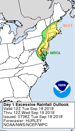
front entering the region. Modest height falls with the approaching shortwave combined with the lingering right entrance region forcing from an upper jet streak to the northeast will provide the right dynamics to tap into the rich tropical moisture that’s available in the region. With left-over atmospheric moisture from Florence around, precipitable water values are 2-3″ above normal; as such, with the right dynamics, that column of moisture could be rained out of the sky, possibly producing flooding conditions on the ground.


However, the speed of the system will be a limiting factor in terms of the areal coverage of excessive short term rainfall rates. As such, the flash flood threat today will be more limited than it was yesterday and Sunday over portions of the interior Mid Atlantic region.

Tomorrow, Florence’s remnants and the other dynamics around should push off-shore, allowing for a brief break in the unsettled weather across the region.

Primary Sidebar

Sponsored Ad

Search

Latest News

  • 2023 Groundhog Day Forecast In: 6 More Weeks of Winter
  • Green Comet to be Visible Tonight; It’ll Visit Earth Again in 45,000 Years
  • Today is the 20th Anniversary of Space Shuttle Columbia Disaster
  • Loud Explosions over Portions of New Jersey Likely on Saturday; Won’t be Thunder
  • Light Snow Showers Likely in Mid Atlantic to Kick-Off February
  • Mega Tsunami that Wiped Out Dinosaurs Simulated by International Experts
  • Heavy Rain and Snow Helped, but Drought Persists in West
  • Today Marks 37th Anniversary of Space Shuttle Tragedy
About | Careers | Contact | Contests
Terms | Privacy | Ad Choices
Weatherboy is a (R) Registered Trademark of isarithm LLC, All Rights Reserved.
All content herein is Copyright by Isarithm LLC 1997-2022