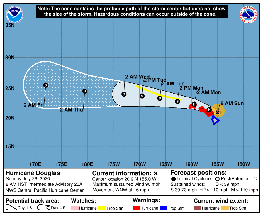
Hurricane Douglas continues to march into Hawaii, becoming the strongest storm to do so from the east into Maui and Oahu counties today. The Central Pacific Hurricane Center (CPHC) in Honolulu, Hawaii upgraded the Hurricane Watch in effect in Maui County to a Hurricane Warning this morning. Maui County includes the islands of Maui, Lanai, Molokai and Kahoolawe. A Hurricane Warning remains in effect for the island of Oahu and the county of Kauai, which includes the islands of Kauai and Niihau. On the Big Island of Hawaii, a Tropical Storm Warning remains in effect. A Tropical Storm Watch remains in effect for portions of the Papahanaumokuakea Marine National Monument from Nihoa to French Frigate Shoals to Maro Reef.
As of the latest update from the CPHC, Hurricane Douglas was located 90 miles east of Kahului, Hawaii, home of the “OGG” airport that most visitors flying into Maui arrive at. The storm is located about 185 miles east of Honolulu, Hawaii; Honolulu is located on the island of Oahu and is sandwiched between Pearl Harbor to its west and Waikiki Beach to its east. Maximum sustained winds remain at 90 mph while minimum central pressure is 987 mb or 29.15 inches. Specifically, the hurricane is near latitude 20.9 North, longitude 155.0 West.
Right now, Hurricane Douglas is moving toward the west-northwest near 16 mph and this motion is expected to continue over the next couple of days. According to the CPHC, on this forecast track, Douglas will pass near, or over, the islands from Maui to Kauai today and tonight. While some gradual weakening is expected over the next 48 hours, Douglas is expected to remain at hurricane strength as it moves through Hawaii. The area that contains hurricane force winds is rather compact inside the storm, extending roughly 30 miles out from the center. The field of tropical storm force winds is larger, extending out 105 miles from the center.
A variety of life-threatening, destructive hazards will impact Hawaii today and tonight: severe winds, violent surf and storm surge, and flooding rains. Severe downslope winds could also fan wildfires should any ignite on Maui or Hawaii islands.
Hurricane-force wind conditions are expected in portions of Maui County today, on Oahu by this afternoon, and on Kauai and Niihau tonight. Tropical Storm conditions are imminent across the northern part of the Big Island from North Kohala east to North Hilo. Below Saddle Road on Hawaii Island, we expect few impacts on land. But even in the Tropical Storm Warning area on Hawaii Island, due to the steep terrain there, hurricane-force wind gusts are possible. The same will be true in Maui and Kauai County and the island of Oahu as the storm moves through the state.
Large swells generated by Douglas will affect the Hawaiian Islands into Monday, producing life threatening and potentially destructive surf along exposed shores. The combination of higher than predicted water levels, dangerous storm surge, and large breaking waves, some in excess of 15′, will raise water levels by as much as 3 feet above normal tides near the center of Douglas. Even expert swimmers and surfers should avoid the ocean until the storm passes through.
Heavy rainfall associated with Douglas is expected to affect portions of the main Hawaiian Islands from early this morning into Monday. Total rain accumulations of 5-10″ are possible from Maui County westward to Kauai County, with the greatest amounts up to 15″ in elevated terrain. This rain may result in life-threatening flash flooding and land slides, as well as rapid water level rises on small streams. Further south Douglas could produce an additional 2-4″ in the northernmost portions of Hawaii’s Big Island.