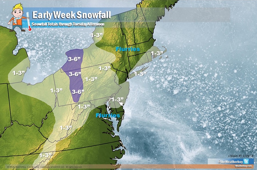
A round of light snow is expected in portions of the Northeast and Mid Atlantic later today into tomorrow. After more significant snowfall earlier in the season, amounts from this weather system will pale in comparison. A widespread 1-2″ is expected, with a few areas perhaps getting as much as 3-4″. Light snow will fall beyond the area we’re forecasting accumulation; in areas not covered by the snowfall map, flurries will fly but will struggle to accumulate, especially on paved surfaces. Places like New York City and Washington, DC are examples of cities that could see snow flakes fly and fall, with little to no accumulation expected.
The system producing light snow will be a fast mover. Low pressure developing along a stationary front will track northeastward up the Southeast coast today and then off the Mid-Atlantic coast tonight. A weak disturbance will pass through the region on Tuesday, with high pressure building in Tuesday night and Wednesday.
The next weather system is expected to pass through eastern Canada late in the week with the attendant cold front forecast to move through the Northeast either Thursday night or Friday. Originally, forecast guidance suggested that an area of low pressure will form on this attendant cold front and produce accumulating snow on the I-95 corridor between Baltimore, MD and Boston, MA. At this time, it doesn’t appear that much of a low will form. While another round of snow is likely around or after Groundhog’s Day, amounts will probably be light again. Once that next system exits on Saturday, high pressure will return keeping the region dry.
The weather pattern could support more substantial winter storm events beyond next weekend, but it is too soon to get into specifics with a high degree of accuracy or confidence at this time.
